Day 3 Convective Outlook
Issued: · Valid: –
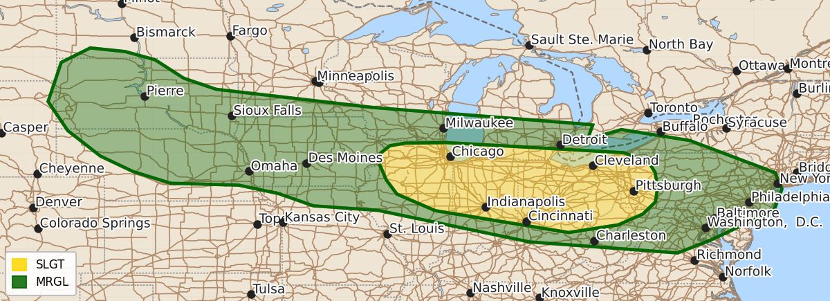
Summary
Severe thunderstorms with damaging wind gusts are possible on Monday from northern Illinois eastward into Pennsylvania. Isolated severe wind gusts and hail may also occur across parts of the central and northern Plains into the Midwest.
Product Text
000 ACUS03 KWNS 081932 SWODY3 SPC AC 081931 Day 3 Convective Outlook NWS Storm Prediction Center Norman OK 0231 PM CDT Sat Aug 08 2026 Valid 101200Z - 111200Z ...THERE IS A SLIGHT RISK OF SEVERE THUNDERSTORMS FROM ILLINOIS EASTWARD INTO PENNSYLVANIA... ...SUMMARY... Thunderstorms with severe wind gusts will be possible on Monday from northern Illinois eastward into western Pennsylvania. Isolated severe gusts and hail will also be possible from parts of the central and northern Plains into the Midwest. ...Midwest / OH Valley / Mid Atlantic... An elongated zone of damaging wind potential will exist on Monday from Illinois to the Mid Atlantic, with various clusters of storms throughout the period. Earlier in the day, it appears ongoing activity may be present around OH, with moderate 40+ kt midlevel westerlies pushing the activity toward the Mid Atlantic during the afternoon. There, it could encounter the destabilizing air mass, with possible new development and/or rejuvenation with damaging gust potential. Farther west, a large area of strong instability is forecast across the Midwest, with an east-west oriented boundary roughly from IA across northern IL/IN/OH. Parts of this boundary may be re-positioned depending on the extent of early day outflows. West to southwest 850 mb winds over 30 kt should help maintain low-level moisture/heat flux into the frontal zone, with new development most likely across the Slight Risk area from northern IL into OH. Corridors of damaging winds will be possible with the resulting clusters or MCS, possibly affecting northern KY into WV. Predictability remains fairly low or this pattern. ...Northern Plains... Low pressure is forecast to develop over the central Plain, while moisture and backed surface winds persist generally north of I-80. Strong heating and surface convergence should support afternoon development over western SD, and perhaps elevated storms later over ND. Isolated severe gusts or hail will be possible over SD and vicinity, perhaps into northern NE and western IA overnight. A targeted Slight Risk may be needed in later updates as predictability increases. ..Jewell.. 08/08/2026 $$