Day 3 Convective Outlook
Issued: · Valid: –
Summary
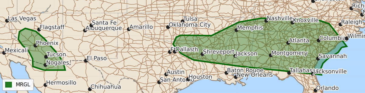
Scattered strong thunderstorms capable of causing wind damage are expected across much of the Southeast on Sunday. Additionally, strong thunderstorms are possible across portions of Arizona from late Sunday afternoon into Sunday night.
Product Text
000 ACUS03 KWNS 101905 SWODY3 SPC AC 101904 Day 3 Convective Outlook NWS Storm Prediction Center Norman OK 0204 PM CDT Fri Jul 10 2026 Valid 121200Z - 131200Z ...THERE IS A MARGINAL RISK OF SEVERE THUNDERSTORMS ACROSS PORTIONS OF THE ARKLATEX INTO THE SOUTHEAST...AND ACROSS PARTS OF ARIZONA... ...SUMMARY... Scattered strong-to-severe thunderstorms capable of producing wind damage will be possible across much of the Southeast on Sunday. Additional strong-to-severe thunderstorms will be possible across portions of Arizona late Sunday afternoon into Sunday night. ...Synopsis... An upper anticyclone will persist across portions of Great Basin into Wyoming. Enhanced easterly flow on the southern periphery of this feature will overspread portions of AZ. Further east, a closed upper low is forecast to develop over the Ohio Valley, with a surface low meandering across KY toward the central Appalachians. An outflow boundary is expected to be oriented across portions of the TN Valley westward into the southern Plains. ...ArkLaTex to GA/SC... A very moist airmass will be in place along/south of the surface boundary draped west to east across the region. These upper 60s to low 70s F dewpoints and strong heating will support moderate to strong instability and convection should develop by early afternoon along the surface boundary. Vertical shear will remain modest, generally around 20 kt or less, suggesting short-lived single cells and multicells clusters will be possible. High PW values and strong instability will support strong gusts with sporadic wind damage possible. ...AZ... Steep midlevel lapse rates and ample midlevel moisture will support isolated to scattered thunderstorm development within a weakly unstable airmass. A deeply mixed boundary layer and steep low-level lapse rates will allow for strong outflow winds as convection generally spreads westward across portions of southern into central AZ. ..Leitman.. 07/10/2026 $$