Day 2 Convective Outlook
Issued: · Valid: –
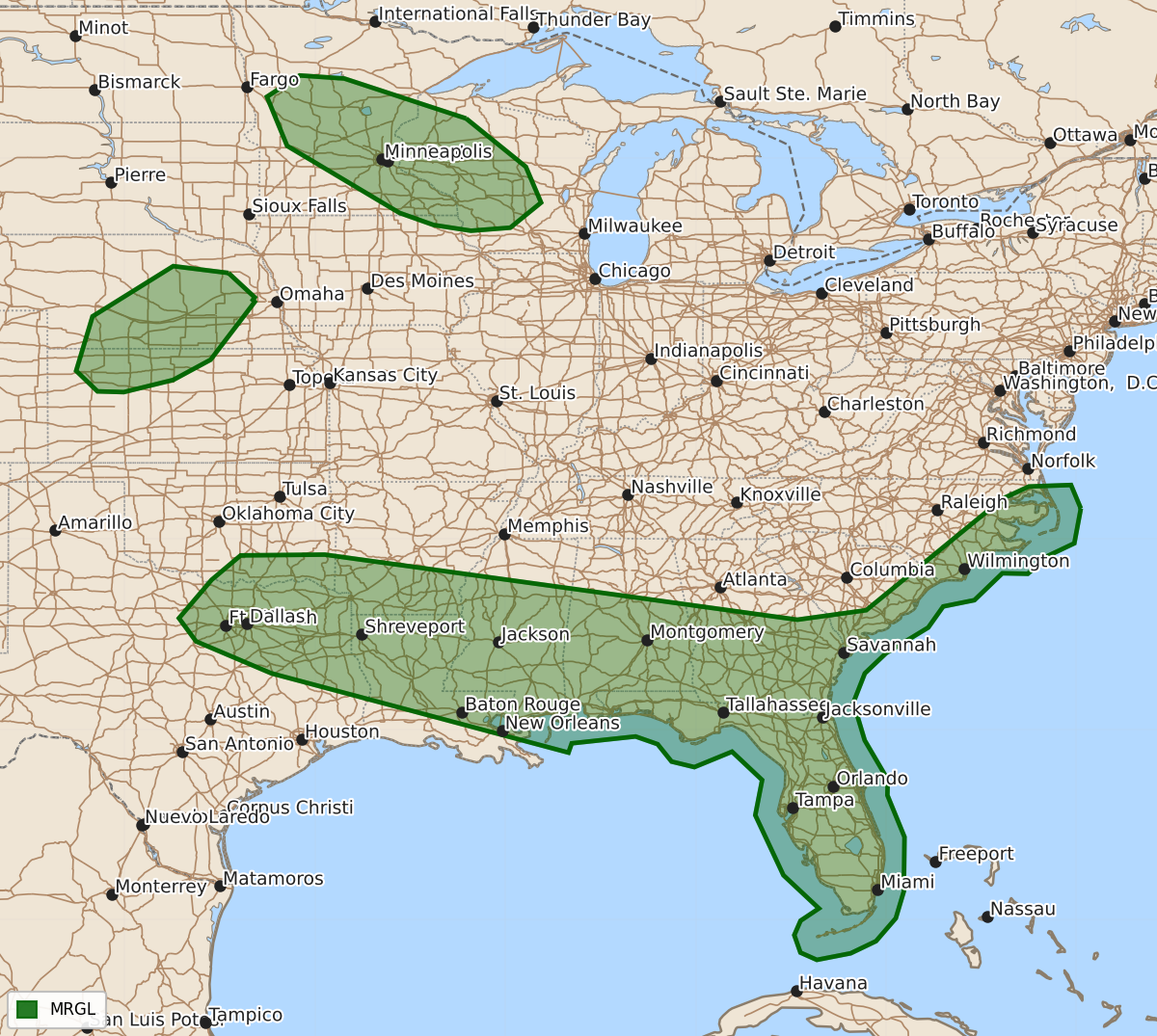
Summary
Marginal severe thunderstorms are expected Thursday through Friday across the Upper Mississippi Valley, the central Plains, the ArkLaTex/Southeast, and the coastal Carolinas. These storms may produce damaging wind gusts, large hail, and brief tornadoes.
Product Text
000 ACUS02 KWNS 181730 SWODY2 SPC AC 181728 Day 2 Convective Outlook NWS Storm Prediction Center Norman OK 1228 PM CDT Thu Jun 18 2026 Valid 191200Z - 201200Z ...THERE IS A MARGINAL RISK OF SEVERE THUNDERSTORMS WITHIN THE UPPER MISSISSIPPI VALLEY...PARTS OF THE CENTRAL PLAINS...ARKLATEX INTO THE SOUTHEAST AND COASTAL CAROLINAS... ...SUMMARY... Isolated strong storms may produce gusty winds and hail across the Upper Midwest and parts of the central Plains. Additional strong thunderstorms may produce damaging wind gusts from north Texas/southern Oklahoma through portions of the Gulf Coast states and into the coastal Carolinas. ...Synopsis... The primary upper-level trough is expected to move off the Northeast coast on Friday. Another compact shortwave trough will move into the northern Plains/Upper Midwest. A remnant tropical low will move into the Carolinas. A stalled cold front will extend from the Carolinas into the southern Plains with another weak cold front from the Upper Midwest into the central High Plains. ...Coastal Carolinas... With the remnants of a tropical low beginning to phase with the upper trough in the east, a window of severe risk will occur during the morning in the coastal regions of the Carolinas. Enhanced low-level flow associated with the remnant circulation will promote a risk for damaging winds and a brief tornado near the circulation itself and along a pseudo warm front. ...Upper Mississippi Valley... While moisture return is a bit uncertain, generally 50s F dewpoints are expected to advect northward into the Upper Mississippi Valley. A compact, moderately strong shortwave trough will likely promote thunderstorm development during the afternoon along the surface trough/weak cold front. The potent mid-level jet will bring 45-55 kt of effective shear to the region. 500-1000 J/kg MLCAPE is expected despite the limited moisture as temperatures aloft (-18 to -20 C at 500 mb) will accompany the trough. Isolated to widely scattered supercells are possible. Isolated large hail and severe wind gusts are possible. ...ArkLaTex into Southeast... An MCV is anticipated along the Red River during the morning. This feature, coupled with heating of a very moist (70+ F dewpoints) airmass along and south of a stalled cold front will promote scattered thunderstorms during the afternoon. Deep-layer shear will be weak, particularly away from the cold front, and storm organization will depend on the MCV or mesoscale clustering. Damaging downburst winds are the main hazard with this activity. Similar activity can be expected along the Atlantic sea breeze front from near Jacksonville to the Space Coast. ...Northwest Kansas into central Nebraska... Modest moisture return on the western flank of the surface high will potentially allow thunderstorms to develop along the surface trough/weak cold front. Surface convergence will be weak and mid-level ascent will be nebulous at best. Coverage is likely to be isolated if storms can form. Moderate mid-level winds will promote 40-50 kt of effective shear. Storm mode would likely be supercellular with a risk of severe wind gusts and large hail. ...Northern Sierra/Northwest Nevada... A modest upper-level low and mid-level moisture will promote widely scattered to scattered thunderstorms within the northern Sierra. Some of this activity may become marginally organized given stronger mid-level winds. Small hail and strong outflow winds are possible. Overall coverage of marginally severe activity still appears too low for probabilities. ..Wendt.. 06/18/2026 $$