Day 2 Convective Outlook
Issued: · Valid: –
Summary
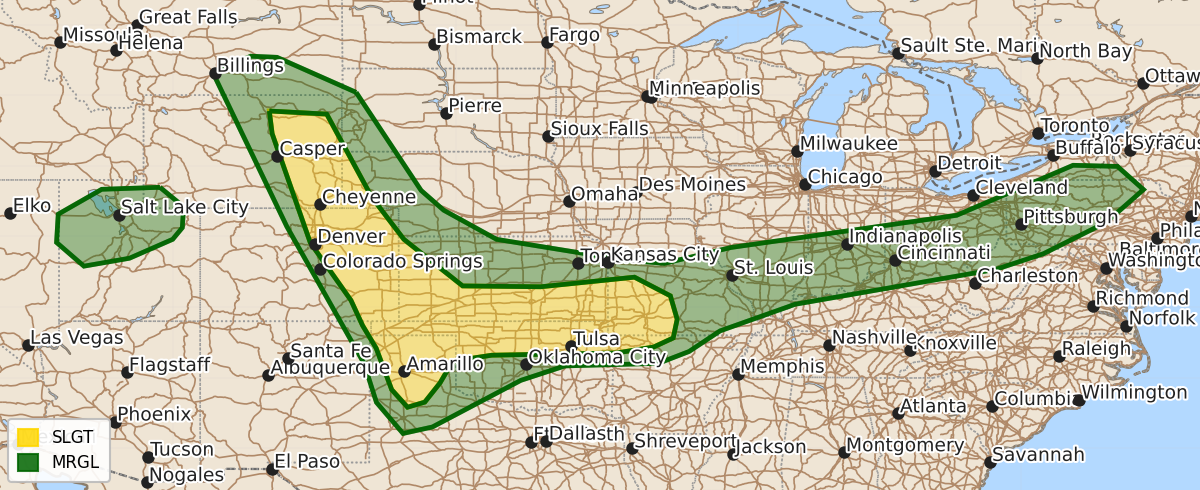
Scattered strong to severe thunderstorms are possible Thursday across the High Plains, southern Kansas, northern Oklahoma, the Ozarks, and the Ohio Valley, bringing threats of large hail, damaging winds, and a few tornadoes. Additionally, northern Utah may see scattered severe thunderstorms with the potential for damaging winds on Thursday afternoon.
Product Text
000 ACUS02 KWNS 241737 SWODY2 SPC AC 241735 Day 2 Convective Outlook NWS Storm Prediction Center Norman OK 1235 PM CDT Wed Jun 24 2026 Valid 251200Z - 261200Z ...THERE IS A SLIGHT RISK OF SEVERE THUNDERSTORMS ACROSS PORTIONS OF THE CENTRAL/SOUTHERN HIGH PLAINS INTO SOUTHERN KANSAS AND NORTHERN OKLAHOMA AND INTO THE OZARKS... ...SUMMARY... Scattered strong to severe storms are possible across portions of the High Plains with a threat for large hail and severe wind. Storms are also expected across southern Kansas and northern Oklahoma into the Ozarks where large hail, severe winds, and a few tornadoes are all possible. ...Synopsis... Zonal flow will bring broad westerly flow aloft across much of the central Rockies into the central/southern Plains D2/Thursday. Within the broad upper-level flow, several perturbations will rotate across the central/southern Plains. Further east, a more potent shortwave trough with a band of enhanced westerly flow will move across the Ohio Valley. At the surface, a cold front will extend from Wisconsin south and west into the central Plains shifting south and eastward into the Ohio Valley through the afternoon. A surface low will deepen across the Texas/Oklahoma Panhandles through the evening. ...High Plains... A shortwave trough moving out of Montana will bring forcing for ascent and thunderstorm development by the afternoon across portions of the High Plains. Guidance suggests that ahead of this feature, widespread cloud cover will be in place across much of the central/northern Rockies Thursday morning/early afternoon. This may inhibit destabilization, especially with northern extent into portions of eastern Montana/northern Colorado. Nonetheless, it appears at least marginal instability will be achieved by late afternoon through filtered daytime heating along and east of the Rockies. This in combination with deep layer shear around 30-40 kts will support organized clusters capable of damaging wind. Somewhat better heating is expected across southeastern Colorado, where less cloud cover is expected. Across this region, supercells will be possible with potential for large hail and damaging wind. ...Northern Oklahoma/southern Kansas into the Ozarks... A quick moving shortwave trough will likely support potential for an MCS/cluster of thunderstorms to be ongoing Thursday morning into portions of northern Oklahoma/southern Kansas. The exact location of this and resulting remnant outflow boundary placement will have a large impact on afternoon severe potential. Model trends in the 12z guidance have been to push this boundary further south into portions of northern Oklahoma, with the best instability also being shunted further south. Afternoon thunderstorm development should be centered along the intersection of the remnant outflow/cold front from southern Kansas into northern Oklahoma. Moderate instability and deep layer shear around 30-45 kts will support supercells, with storm motions likely to be along-boundary. There remains strong signal that a 40-50 kt southwesterly low-level jet will increase into the evening across Oklahoma into southern Kansas. This in combination with favorable along boundary storm motions will support potential for tornadoes, a few of which could be strong. The main uncertainty remains in the exact placement of the boundary relative to the more favorable corridor of instability/low-level jet axis. The 5% tornado area was shifted southward with this update to account for recent trends. It is possible that if more confidence in the placement of these features occurs, higher probabilities may be needed. For now, confidence remains moderate in supercells developing with potential for large to very large hail and damaging wind. ...Portions of the Ohio Valley into southern New York... Development is expected along the cold front from southern New York into the Ohio Valley Thursday afternoon as a jet streak moves across the region with increasing forcing for ascent. Moderate instability and strong deep layer shear ahead of this will support organized storms and perhaps a few transient supercells with potential for damaging wind and large hail. The Marginal Risk was expanded along the front into portions of Indiana/southern Ohio/northern Kentucky to account for this potential extending along the entirety of the cold front. ...Northern Utah... Widely scattered thunderstorm activity is expected across portions of Utah Thursday afternoon. Steep low to mid-level lapse rates are expected with very dry near-surface conditions. Modest instability will overlap with strong deep layer shear across northern Utah by the afternoon. Forecast soundings indicate large inverted-v profiles and potential for severe winds. A Marginal Risk was added to the area to account for this potential. ..Thornton.. 06/24/2026 $$