Day 2 Convective Outlook
This product has been superseded. View the updated product →
Issued: · Valid: –
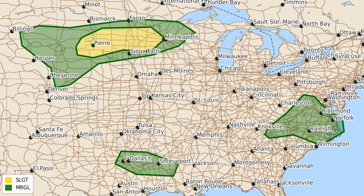
Summary
Severe thunderstorms capable of producing strong wind gusts are expected late Tuesday through Tuesday night across parts of central and eastern South Dakota and southwestern Minnesota. Additionally, thunderstorms with the potential for damaging wind gusts may occur late Tuesday afternoon or evening east of the Blue Ridge Mountains and in the Ark-La-Tex vicinity.
Product Text
000 ACUS02 KWNS 060512 SWODY2 SPC AC 060510 Day 2 Convective Outlook NWS Storm Prediction Center Norman OK 1210 AM CDT Mon Jul 06 2026 Valid 071200Z - 081200Z ...THERE IS A SLIGHT RISK OF SEVERE THUNDERSTORMS LATE TUESDAY THROUGH TUESDAY NIGHT ACROSS PARTS OF CENTRAL AND EASTERN SOUTH DAKOTA INTO SOUTHWESTERN MINNESOTA... ...SUMMARY... Strong thunderstorms, which may evolve into an organized cluster with increasing potential to produce severe wind gusts by late Tuesday evening, are possible across parts of central and eastern South Dakota into southwestern Minnesota. Other thunderstorm clusters may form to the east of the Blue Ridge Mountains and southwest of the Ark-La-Tex vicinity and pose a risk for damaging wind gusts late Tuesday afternoon or evening. ...Discussion... It still appears that the westerlies may become a bit less progressive across the higher latitudes of North America by Tuesday. As a mid/upper high evolves in the northwestern Canadian Arctic latitudes, a deep remnant lower/mid-tropospheric cyclone may only slowly migrate east-northeastward across Hudson Bay, toward the northern Quebec shores, while a notable upstream trough slowly pivots inland of the British Columbia coast. In advance of the trailing perturbation, low-amplitude troughing, comprised of at least a couple smaller-scale perturbations within the modest zonal westerlies across the northern tier of the U.S., is forecast to progress east of the northern Rockies. As it does, models suggest that it will gradually flatten initial mid-level ridging across the middle Missouri Valley Tuesday through Tuesday night. Otherwise, mid-level ridging is forecast to remain prominent along an axis from the subtropical eastern Pacific through the central and southern Great Plains, while also developing northwestward from the subtropical western Atlantic into parts of the southeast. It appears that weak mid-level troughing will dig across the southern New England and northern Mid Atlantic coast, leaving a remnant shear axis between the ridging, roughly from the Ohio Valley into southeastern Great Plains, with perhaps a well-defined, quasi-stationary circulation along it across the Mid South vicinity. ...Parts of the middle Missouri Valley into Upper Midwest... Beneath steep mid-level lapse rates, associated with a plume of elevated mixed-layer air slowly becoming suppressed southward across the middle Missouri Valley, it still appears that stronger boundary-layer heating may contribute to moderate to strong destabilization by late Tuesday afternoon. Guidance suggests that this will focus in a corridor along/south of a stalling surface cold front trailing the Hudson Bay cyclone, along which surface dew points increasing to near 70F may contribute to CAPE in excess of 2000 J/kg. Although timing of stronger thunderstorm initiation remains uncertain, this probably will be aided by forcing for ascent associated with the approaching mid-level perturbations. Once this occurs, deep-layer shear appears likely to become at least marginally supportive of supercell structures. Particularly by late Tuesday evening, near the nose of a nocturnally strengthening boundary-layer jet across central into eastern South Dakota, the evolution of an upscale growing and organizing cluster appears possible, accompanied by increasing potential to produce strong to severe wind gusts as it propagates eastward. ...Mid Atlantic... Both HREF and REFS calibrated thunderstorm guidance are similar with highest probabilities for thunderstorms becoming concentrated along and east of the Blue Ridge by late afternoon. Although embedded within deep-layer westerly mean flow on the order of 20 kt or less, thermodynamic profiles with high precipitable water content and modest CAPE may support locally strong downbursts in stronger storms. There does appear at least some potential for weak low-level warm advection to provide support for an upscale growing cluster propagating southeastward toward coastal areas by Tuesday evening, with continuing risk for potentially damaging winds along a consolidating gust front. ...Northeast Texas into northern Louisiana... Both HREF and REFS calibrated thunderstorm guidance currently focus higher thunderstorm probabilities by late Tuesday afternoon across the region, near the southwestern periphery of the broad, weak mid-level cyclonic circulation. Aided by inflow of moderate potential instability, within a corridor of stronger daytime heating, some clustering of storms appears possible, accompanied by potential for a few strong downbursts. ..Kerr.. 07/06/2026 $$