Day 3 Convective Outlook
Issued: · Valid: –
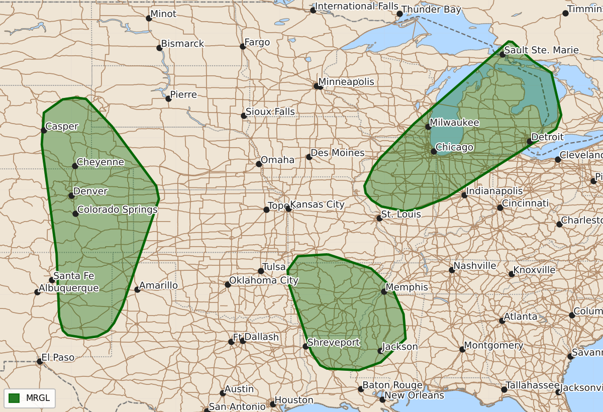
Summary
Isolated to widely scattered severe thunderstorms are expected Tuesday through Wednesday across parts of the central and southern High Plains, the Great Lakes and Ohio Valley, and the Lower Mississippi Valley. These storms may produce damaging wind gusts and hail.
Product Text
000 ACUS03 KWNS 241931 SWODY3 SPC AC 241930 Day 3 Convective Outlook NWS Storm Prediction Center Norman OK 0230 PM CDT Mon Aug 24 2026 Valid 261200Z - 271200Z ...THERE IS A MARGINAL RISK OF SEVERE THUNDERSTORMS FOR PARTS OF THE SOUTHERN AND CENTRAL HIGH PLAINS...GREAT LAKES INTO THE OHIO VALLEY...AND PARTS OF THE LOWER MISSISSIPPI VALLEY... ...SUMMARY... Isolated to widely scattered severe storms are expected across parts of the central and southern High Plains, Great Lakes into the Ohio Valley, and parts of the Lower Mississippi Valley. Damaging/severe gusts are the main threat across these regions. ...Synopsis... An upper ridge will stagnate over the western and central CONUS through Wednesday, with an upper trough expected to progress over eastern Canada, resulting in a broad northwesterly upper-air regime with surface troughing over the MS Valley and Midwest. Seasonably rich low-level moisture will overspread portions of the High Plains, as well as the Great Lakes and portions of the Lower MS Valley, aiding in the development of scattered strong to severe thunderstorms. ...Central and Southern High Plains... Another day of moist upslope low-level flow is expected across portions of the central and southern High Plains, where orographic lift will support convective initiation by mid afternoon. 60s F surface dewpoints will advect northwestward beneath mid-level lapse rates of at least 8 C/km, yielding 2000-3000 J/kg MLCAPE. Deep-layer shear should remain rather modest, but given modestly elongated hodographs, over 30 kts of effective bulk shear is likely in spots, which will support at least transient supercells. Isolated instances of severe wind and hail are the primary threats. If greater storm coverage and/or shear becomes apparent, a Slight Risk upgrade may be needed in future outlooks. ...Great Lakes into the OH Valley... A wedge of 60s F surface dewpoints will advect north-northeast ahead of the approaching surface trough, beneath 6-6.5 C/km mid-level lapse rates, resulting in 1500-2500 J/kg MLCAPE. Thunderstorm initiation should take place along/ahead of the surface trough as surface temperatures rise into the mid 70s F by afternoon. Modest veering and strengthening of the flow with height will encourage over 35 kts of effective bulk shear, characterized by hodographs with some curvature and elongation. Multicells, line segments, and supercells are the expected storm mode, with severe wind/hail the primary concerns. At the moment, expected limited storm coverage precludes Slight risk probabilities. ...Lower MS Valley... Thunderstorm development is expected Wednesday afternoon with the heating of a very moist boundary layer, characterized by mid 70s F surface dewpoints. Some organization into multicellular complexes is possible given modest vertical speed shear as the region is grazed by the aforementioned deep-layer northwesterly flow. MLCAPE will likely reach 2000-3000 J/kg supporting wet downbursts with damaging gust potential. ..Squitieri.. 08/24/2026 $$