Day 1 Convective Outlook
Issued: · Valid: –
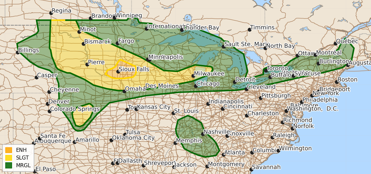
Summary
Enhanced risk of severe thunderstorms featuring large hail and damaging winds is expected across far eastern South Dakota, far southwest Minnesota, and extreme northwest Iowa this evening. Isolated severe storms capable of producing large hail and damaging winds are also possible across the Central High Plains and portions of the Great Lakes throughout the night.
Product Text
000 ACUS01 KWNS 030046 SWODY1 SPC AC 030045 Day 1 Convective Outlook NWS Storm Prediction Center Norman OK 0745 PM CDT Thu Jul 02 2026 Valid 030100Z - 031200Z ...THERE IS AN ENHANCED RISK OF SEVERE THUNDERSTORMS ACROSS FAR EASTERN SOUTH DAKOTA INTO FAR SOUTHWEST MINNESOTA AND EXTREME NORTHWEST IOWA... ...THERE IS A SLIGHT RISK OF SEVERE THUNDERSTORMS FOR PORTIONS OF THE NORTHERN HIGH PLAINS TO THE GREAT LAKES AND WESTERN KANSAS... ...SUMMARY... Scattered severe storms are still possible from the northern Plains into the Midwest and Great Lakes regions this evening. More isolated severe storms will be possible across the Central High Plains. ...High Plains into the Midwest... Several clusters of thunderstorms are ongoing across portions of the Dakotas into northern Iowa and southern Wisconsin/northern Illinois. Across the western Dakotas, clusters of multi-cell and supercells are ongoing. Given moderate instability and some supercellular modes, large hail to very large hail and damaging wind will continue to be a threat through the evening. Additional thunderstorms may move out of Montana and or southern Canada through the evening with additional chances for large hail and damaging wind. A cluster across southeastern South Dakota moving into Minnesota/Iowa has a history of producing significant gusts 90-100 mph. More recent observations have been around 60-70 mph. It is likely that the damaging wind potential will continue downstream for the next couple of hours, with potential for additional development along the trailing outflow into northern Nebraska later this evening. The 00z sounding from OAX sampled a large cape profile with steep low to mid-level lapse rates.Confidence in exact evolution remains low but some CAM guidance does suggest a secondary MCS structure may move eastward later this evening across northern Iowa. Given the large MLCAPE gradient extending across southern South Dakota into northern Iowa and a continued reservoir of steep low to mid-level lapse rates, this may pose additional potential for damaging wind through the evening. ...Central High Plains... A few isolated supercells are ongoing across portions of eastern Colorado, southern Nebraska, and western Kansas. These have had occasional stronger MESH cores around 2 inches. The 00z sounding from DDC sampled strong instability and steep low to mid-level lapse rates amid large dew point depressions within the near surface profile. Given strong deep layer shear, inverted v soundings, and moderate to strong instability, these supercells will continue to pose a risk for large to very large hail and severe wind. ...Northeast... A line of thunderstorms is sagging southward out of Quebec. These may pose some potential for a few instances of strong to severe wind through the evening. See MCD#1455 for more information. ..Thornton.. 07/03/2026 $$