Day 3 Convective Outlook
This product has been superseded. View the updated product →
Issued: · Valid: –
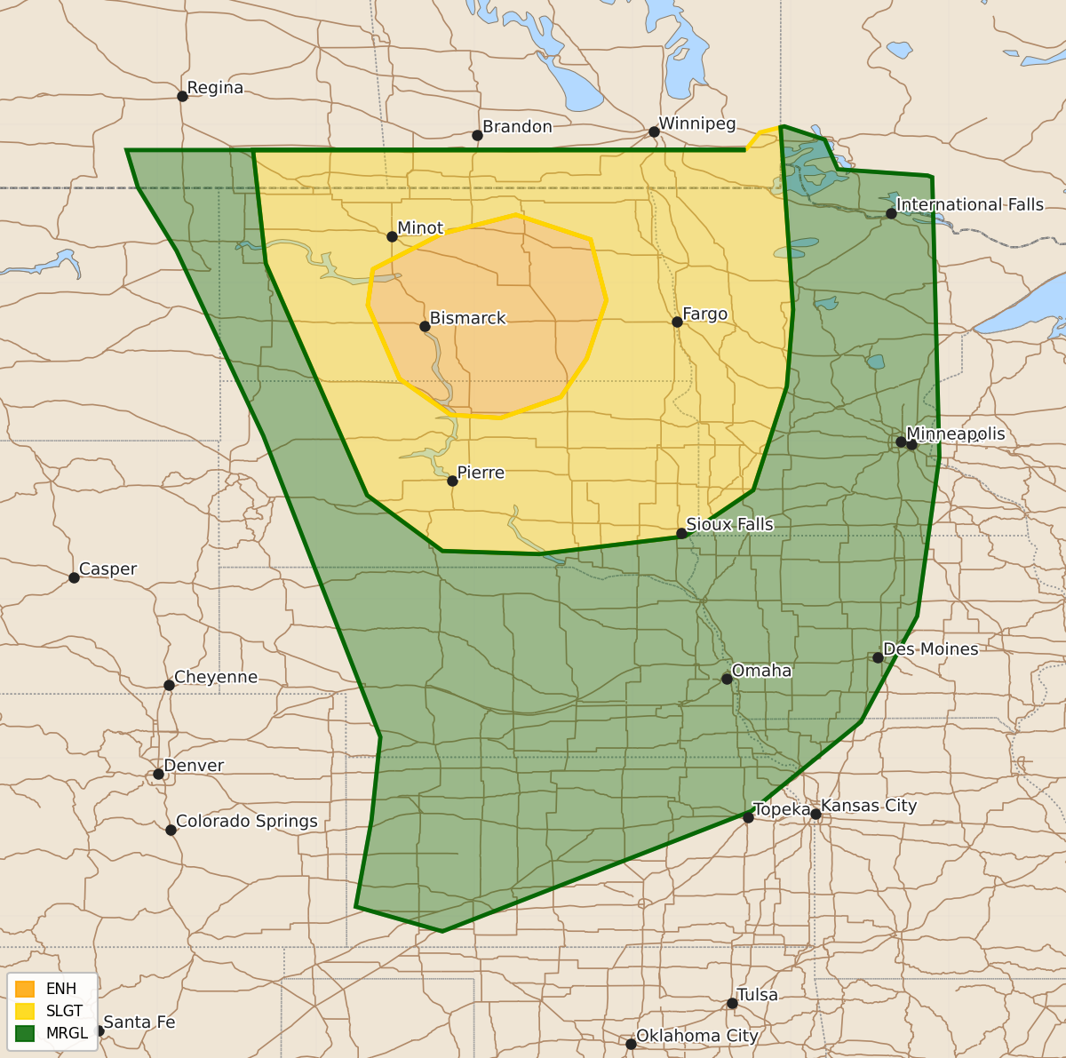
Summary
Scattered to numerous severe thunderstorms are expected to develop across the northern Plains and Upper Mississippi Valley Tuesday afternoon into the night, bringing a risk of all severe-weather hazards. Isolated to widely scattered storms capable of large hail and damaging winds may also occur across the central Plains during the afternoon.
Product Text
000 ACUS03 KWNS 070723 SWODY3 SPC AC 070722 Day 3 Convective Outlook NWS Storm Prediction Center Norman OK 0222 AM CDT Sun Jun 07 2026 Valid 091200Z - 101200Z ...THERE IS AN ENHANCED RISK OF SEVERE THUNDERSTORMS OVER CENTRAL NORTH DAKOTA AND NORTH-CENTRAL SOUTH DAKOTA... ...SUMMARY... Scattered to numerous severe thunderstorms are expected to develop across portions of the northern Plains into Upper Mississippi Valley Tuesday afternoon into night. All severe-weather hazards are possible. Isolated to widely scattered severe storms may also occur across the central Plains, with a risk for large hail and damaging winds. ...Synopsis... A short-wave trough and attending mid/upper-level jet streaks over the northern Rockies Tuesday morning will overspread the northern Plains by afternoon. Farther upstream, a significant short-wave trough will assume an increasing negative tilt while translating into the northern High Plains early Tuesday morning. At the surface, a cyclone linked with the lead short-wave trough will deepen while developing from southeast MT into western ND by afternoon. Meanwhile, an associated Pacific front will push east into the western Dakotas, with more of a dryline structure evident from southwest NE into the OK and TX Panhandles. ...Northern and Central Plains into Upper Mississippi Valley... An active severe-weather period is anticipated Tuesday afternoon into night, especially across the northern Plains, where all severe-weather hazards are possible. While the pre-frontal air mass over the western Dakotas is not expected to be overly moist with dewpoints in the 50s to low 60s, strong daytime heating and steep mid-level lapse rates will contribute to moderate to strong instability by mid to late afternoon. Some potential for early-day storms will exist in northern ND, within a zone of persistent warm advection. Additional, more intense thunderstorm activity is expected by mid afternoon from the southern fringe of the early-day convection south along the front as forcing for ascent increases with the approach of the short-wave trough. Vertically veering wind profiles with 40-50+ kt of deep-layer shear will favor supercells capable of large to very large hail initially. Some tornado threat could materialize during the evening hours as LCL heights lower and the low-level shear increases. With time, storms may grow upscale into clusters, with an increasing risk for damaging winds spreading east through the Red River Valley. Farther south, a number of models develop isolated to widely scattered storms during the afternoon along the dryline in western KS amidst a marginally sheared, but moderate to strongly unstable environment. There is some signal that an MCS could evolve from that activity across the mid to lower MO Valley Tuesday evening. Only 5% total-severe probabilities will be added in those areas, due to uncertainty in that scenario. ..Mead.. 06/07/2026 $$