Day 1 Convective Outlook
Issued: · Valid: –
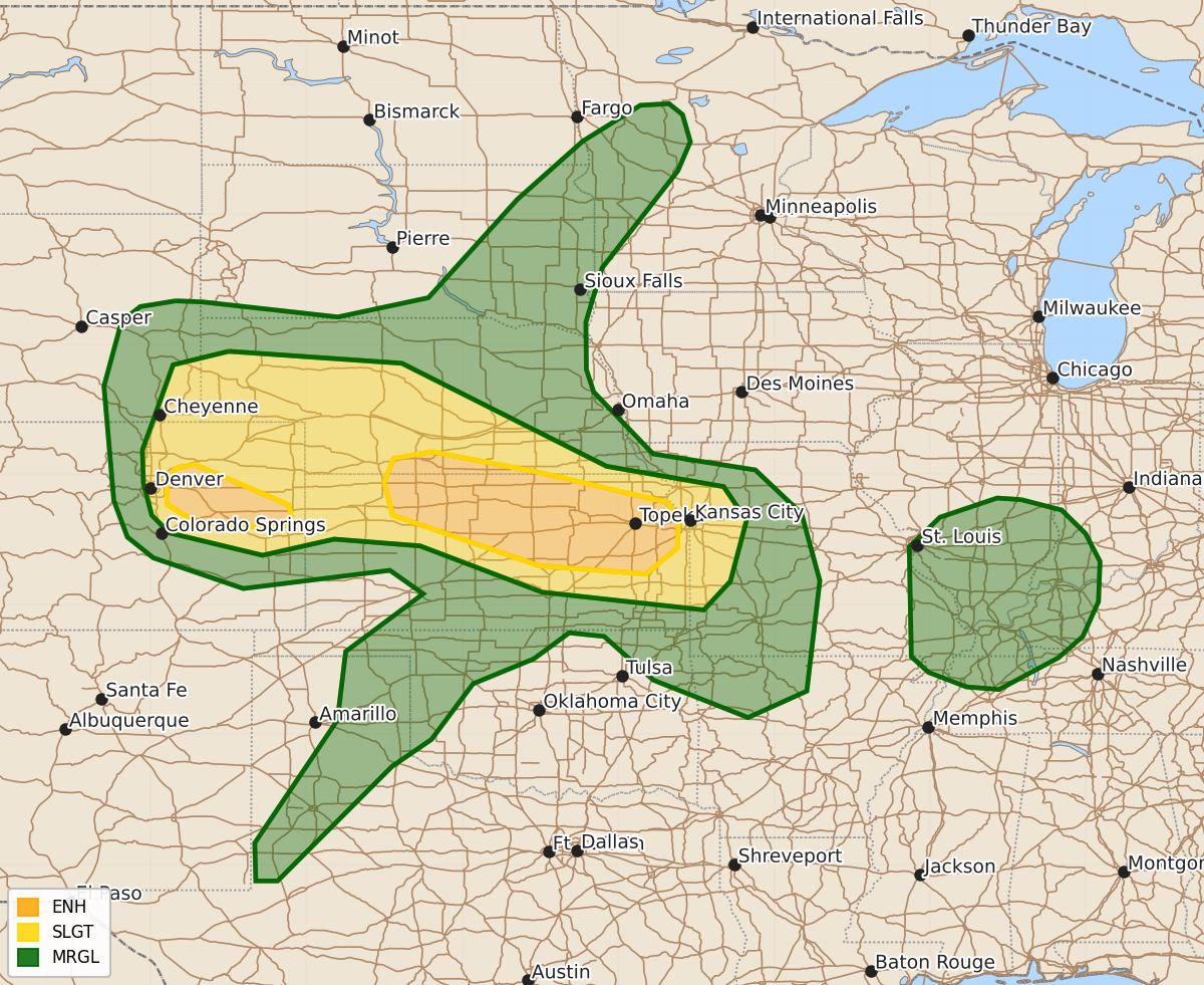
Summary
Severe thunderstorms capable of large to giant hail and tornadoes are expected across eastern Colorado and northern Kansas from late afternoon through late evening. These storms may also produce damaging wind gusts between 60 and 100 mph.
Product Text
000 ACUS01 KWNS 081654 SWODY1 SPC AC 081652 Day 1 Convective Outlook NWS Storm Prediction Center Norman OK 1152 AM CDT Mon Jun 08 2026 Valid 081630Z - 091200Z ...THERE IS AN ENHANCED RISK OF SEVERE THUNDERSTORMS FOR PARTS OF EASTERN COLORADO AND FROM NORTHERN INTO EASTERN KANSAS... ...SUMMARY... Severe thunderstorms potentially capable of large to giant hail and a couple of tornadoes are possible over the plains of eastern Colorado. Scattered to numerous severe thunderstorms are possible farther east over northern Kansas late this afternoon through the late evening. Severe gusts ranging from 60-100 mph are possible along with a risk for a couple of tornadoes. ...Eastern CO into Western NE/KS... A belt of moderate southwesterly mid-level flow will be maintained over the central High Plains to the downstream of a western U.S. upper trough. A surface low near Dodge City, KS and moist easterly low-level flow to its north, will contribute to upslope flow into eastern CO and the CO Front Range. Strong heating and 50s to lower 60s deg F dewpoints and steep 700-500 mb lapse rates will result in moderate to large buoyancy by mid afternoon. Elongated hodographs will favor supercells with the more intense updrafts. Some increase in low-level hodographs towards early evening coupled with a moist boundary layer may aid in the risk for supercell tornadoes, in addition to the risk for hail. Some of the latest model forecast soundings suggest giant hail (3.0-4.5 inches in diameter) with the more intense supercells over eastern CO late this afternoon into the early evening. Severe gusts will also be possible with the stronger storms with this activity diminishing by late evening. ...KS vicinity... A very moist surface was analyzed this morning across the central Great Plains to the south of a front across central and northern KS to the east of a triple point. Model guidance shows lowest 100-mb mean mixing ratios of 16-18 g/kg later this afternoon. This very rich moisture coupled with heating to the south of the front and early day outflow from storm activity over southwest NE, will result in a very unstable airmass by late afternoon. Model guidance has trended towards a severe MCS developing across northern KS and moving east-southeastward into the lower MO Valley by late evening. Although it remains unclear exactly how this will evolve, confidence has increased with regard to a storm cluster and upscale growth occurring on the northern rim of very rich moisture and a modest southerly LLJ. Some indication exists for a couple of supercells to develop ahead of the evolving cluster and eventual squall line. Large hail and perhaps a tornado risk could accompany this activity. Have increased severe-wind probabilities and intensity levels, with the most intense phase of the squall line likely where the overlap of greater effective shear (30-35 kt) and the large buoyancy resides. A bow potentially capable of a swath of 60-80 mph gusts (locally peaking 80-100 mph) is forecast, along with the possibility for a couple of mesovortices capable of these locally higher gusts and/or tornadoes. A gradual weakening is expected as this MCS moves into western parts of MO late. ...Southern KS/Northwest OK... A dryline will become established this afternoon from the eastern TX Panhandle into south-central KS. Hot conditions along/west of the dryline will help to initiate isolated thunderstorms. These high-based supercells could pose an occasional threat of hail and damaging winds for a few hours. ...Southern IL/Western KY... An upper trough continues to lift northeastward across the mid MS valley today, with a moist/moderately unstable air mass present from southern IL southward. Mid-level lapse rates are marginal for severe storms, and winds aloft are modest. Nevertheless, veering winds-with-height and sufficient CAPE will pose an occasional risk of strong storms capable of gusty winds or a tornado today. ..Smith/Chalmers.. 06/08/2026 $$