Day 2 Convective Outlook
Issued: · Valid: –
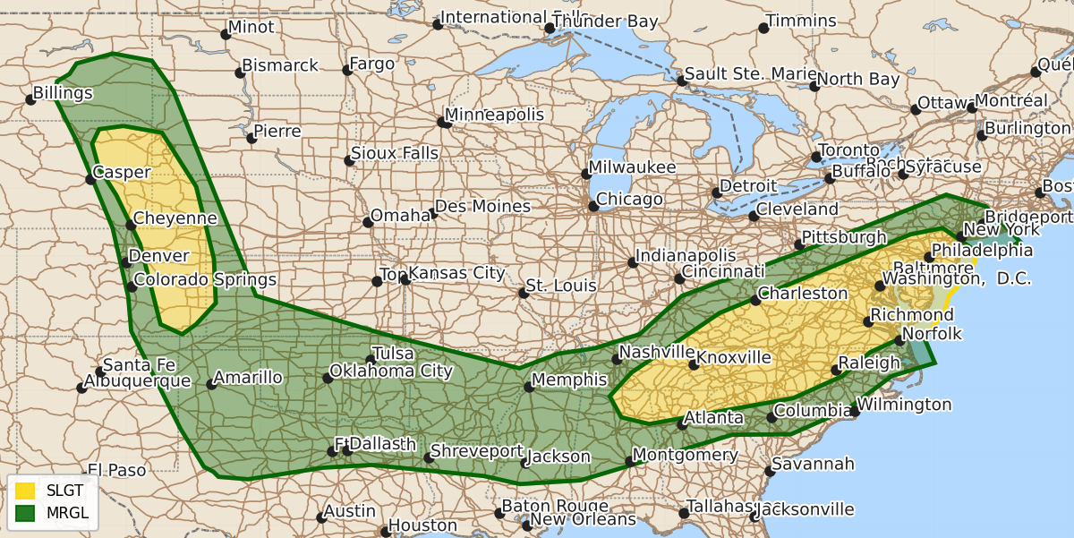
Summary
Scattered severe thunderstorms are expected across portions of the Mid-Atlantic and Southern Appalachians on Monday afternoon and evening, bringing a risk of damaging winds and possible tornadoes. Additionally, widely scattered severe storms are forecast for the northern and central High Plains on Monday afternoon and evening, with the potential for large hail and brief tornadoes.
Product Text
000 ACUS02 KWNS 211723 SWODY2 SPC AC 211721 Day 2 Convective Outlook NWS Storm Prediction Center Norman OK 1221 PM CDT Sun Jun 21 2026 Valid 221200Z - 231200Z ...THERE IS A SLIGHT RISK OF SEVERE THUNDERSTORMS ACROSS PORTIONS OF THE MID-ATLANTIC INTO SOUTHERN APPALACHIANS...AND OVER PARTS OF THE NORTHERN AND CENTRAL HIGH PLAINS... ...SUMMARY... Scattered severe storms appear possible across portions of the Mid-Atlantic into the Southern Appalachians Monday afternoon and evening. Widely scattered severe storms are expected across the northern and central High Plains, with more isolated severe weather possible from the southern Plains into the lower Mississippi Valley. ...Synopsis... A series of perturbations, embedded within broadly cyclonic mid-level flow, will progress eastward to the Atlantic Coast, to the south of an upper low tracking from eastern Ontario into southern Quebec. Farther west, separate vorticity maxima will overspread the northern and central High Plains, in tandem with a belt of strengthening mid-level winds. In the lower levels, a 40-50 kt low-level jet (LLJ) is forecast to migrate from the Allegheny Plateau into the lower Hudson and DE River Valleys Monday afternoon, ahead of a surface low developing toward those same areas. Meanwhile, a trailing cold front will advance south through the central Appalachians, TN Valley, and Ozark Plateau, with the western extension of the boundary linking with a secondary low over western TX. Elsewhere, a lee cyclone is expected to deepen over eastern WY, along a weak front settling southeast through the northern High Plains. ...Mid-Atlantic into the southern Appalachians... 12Z CAM guidance is in relatively good agreement in depicting the remnants of an overnight (Sunday night/early Monday morning) MCS overspreading NY and PA, within a zone of warm air and moisture advection occurring with the terminus of the LLJ. To the south/southeast of that convection across the lower Hudson and DE River Valleys, modest air mass destabilization is expected, with comparably stronger instability with southward extent into the central/southern Appalachians and Piedmont. Deep-layer shear is forecast to strengthen through the day as a belt of 40-50 kt winds at 500 mb overspreads the region from the west. Thunderstorms are expected to increase in areal coverage and intensity during the afternoon from the vicinity of the outflow or differential heating boundary in eastern PA south/southwest into the southern Appalachians and Piedmont. Damaging winds will be the primary hazard owing to steepening low-level lapse rates and high moisture content, which will enhance wet-microburst processes. A relatively narrow corridor of potentially greater tornado potential may materialize from the DelMarVa into the DE River Valley, where stronger low-level shear is forecast. However, given uncertainties in the degree of air mass destabilization in the northern extent of that area, the 2% unconditional tornado probability will be maintained. A separate area of tornado potential may materialize Monday afternoon across parts of the southern Appalachians within the southwest extension of the LLJ, where a number of the 12Z CAMs indicate updraft-helicity swaths embedded within a linear complex of storms. ...Northern and central High Plains... The deepening lee cyclone will enhance the flux of an increasingly moist low-level air mass into the high terrain, beneath a plume of steep mid-level lapse rates, supporting moderate afternoon instability. Greatest storm coverage is expected across portions of eastern MT and western ND Monday afternoon within the northern extent of the instability axis, where the strongest forcing for ascent is expected. Weaker forcing with southward extent is expected to lead to more widely spaced storms in eastern WY and CO. Here, comparatively stronger instability and vertical shear will support supercells capable of large to very large hail and perhaps a brief tornado or two during the afternoon and evening hours. ...Southern Plains... Areas of storms ongoing Monday morning across parts of the Red River Valley into the ArkLaTex region are expected to gradually weaken by midday, owing to rising mid-level heights across the region. In the wake of that activity, moderate to strong instability is forecast by afternoon in the vicinity of the stalled synoptic front and any remnant outflow boundaries. However, considerable uncertainty remains in surface-based storm development given the absence of appreciable forcing for ascent. As such, the low unconditional probabilities will be maintained with this forecast update. On the condition surface-based storms develop and are sustained, the parameter space would support intense supercells capable of large to very large hail and some tornado threat. ..Mead.. 06/21/2026 $$