Day 2 Convective Outlook
Issued: · Valid: –
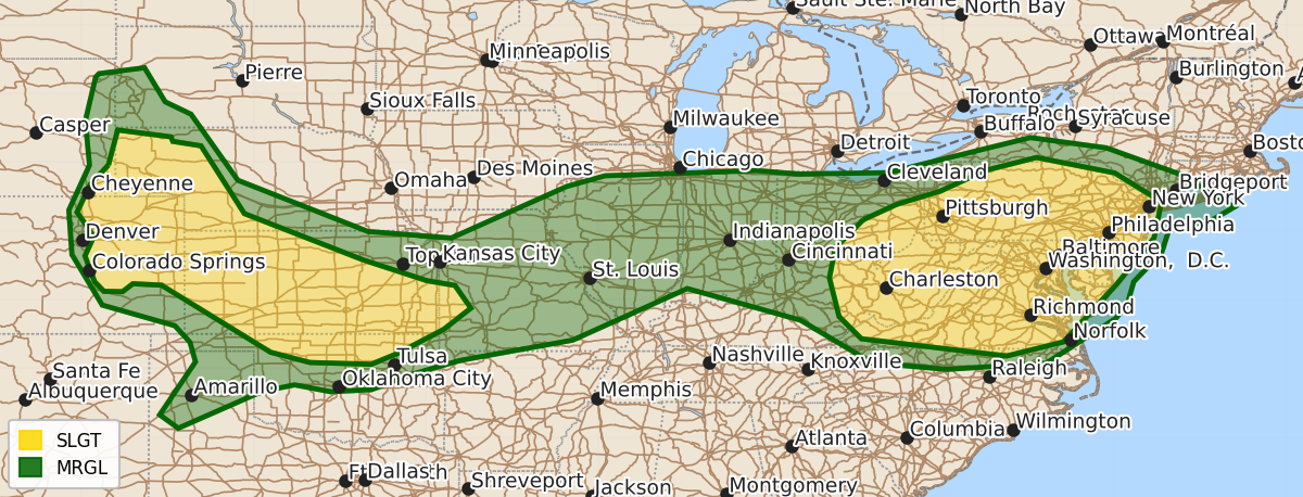
Summary
Severe thunderstorms capable of producing damaging wind gusts and large hail are expected across the central Great Plains and the Mid-Atlantic into the Upper Ohio Valley on Saturday afternoon and evening. The risk includes potential damaging winds across the Great Plains and Mid-Atlantic, with a higher likelihood of large hail and damaging gusts in parts of the central Plains and southern Kansas.
Product Text
000 ACUS02 KWNS 031734 SWODY2 SPC AC 031732 Day 2 Convective Outlook NWS Storm Prediction Center Norman OK 1232 PM CDT Fri Jul 03 2026 Valid 041200Z - 051200Z ...THERE IS A SLIGHT RISK OF SEVERE THUNDERSTORMS FROM THE UPPER OHIO VALLEY INTO THE MID ATLANTIC...AND OVER THE CENTRAL PLAINS... ...SUMMARY... Clusters of storms may evolve across parts of the Allegheny Plateau into Mid Atlantic, and across the central Great Plains Saturday afternoon and evening, posing a risk for damaging wind gusts. Large hail is also possible across the Great Plains. ...Synopsis... An upper trough will be located over eastern Canada, with southern periphery sweeping across the Northeast with 30 kt midlevel westerlies extending as far south as PA/NJ. To the west, a weak upper trough will move across the northern and central Plains, with embedded disturbances related to thunderstorms into parts of the Midwest. Relatively cool temperatures aloft will exist across the Plains region, aiding destabilization. At the surface, a trough will extend from the TX Panhandle into MO, IL, and IN, with a moist and unstable air mass nearby. Easterly winds north of this trough will maintain moderate moisture levels into the central High Plains. A surface trough will also deepen over the Northeast and Mid Atlantic during the day, providing a focus for storms during the afternoon from VA into PA/NJ. ...PA...VA...MD...DE...NJ... Substantial moisture and instability will exist across the region, with tall CAPE profiles and 3000-4000 J/kg MUCAPE common with 70s F dewpoints and daytime heating. Storms may develop in several areas, including southern NY into PA and OH, and, within the trough VA into PA/NJ. CAMs generally suggest scattered cells developing by mid afternoon over much of VA and into PA, MD, DE and NJ. Scattered wind gusts of 40-50 kt appear likely, with isolated stronger gusts. Weak westerlies aloft may support slow east/southeastward moving cells. ...CO...NE...KS... Scattered storms are forecast to develop from southeast WY into the Front Range, as well as western NE, during the afternoon beneath cool temperatures aloft and where low-level easterlies will aid moisture advection into the heated air mass. Directional shear may favor a few cells capable of severe hail, including near the Colorado Springs area. Addition cells or clusters may spread southeastward across western NE and northwest KS, with damaging gusts possible. A more substantial severe risk may develop into south-central KS and perhaps far northern OK late in the day. Here, locally larger SRH will exist north of a weak surface low. Instability will be large as temperatures warm into the 90s F and dewpoints remain in the upper 60s F. Veering wind with height and effective shear near 40 kt suggest a few supercells initially, with large hail and locally damaging wind gusts. A brief tornado cannot be ruled out. During the evening, CAMs suggest an MCS may develop, dropping southeastward across southern KS, including the Wichita area, and into northern OK. Damaging wind gusts would be the main concern. ...Parts of Central MO... CAM signals are mixed with timing of convective systems near the surface trough. However, strong instability will be present across the entire region. Depending on later model output, the Slight Risk may need to be extended farther into MO/I-70 corridor as predictability increases. ..Jewell.. 07/03/2026 $$