Day 4-8 Convective Outlook
Issued: · Valid: –
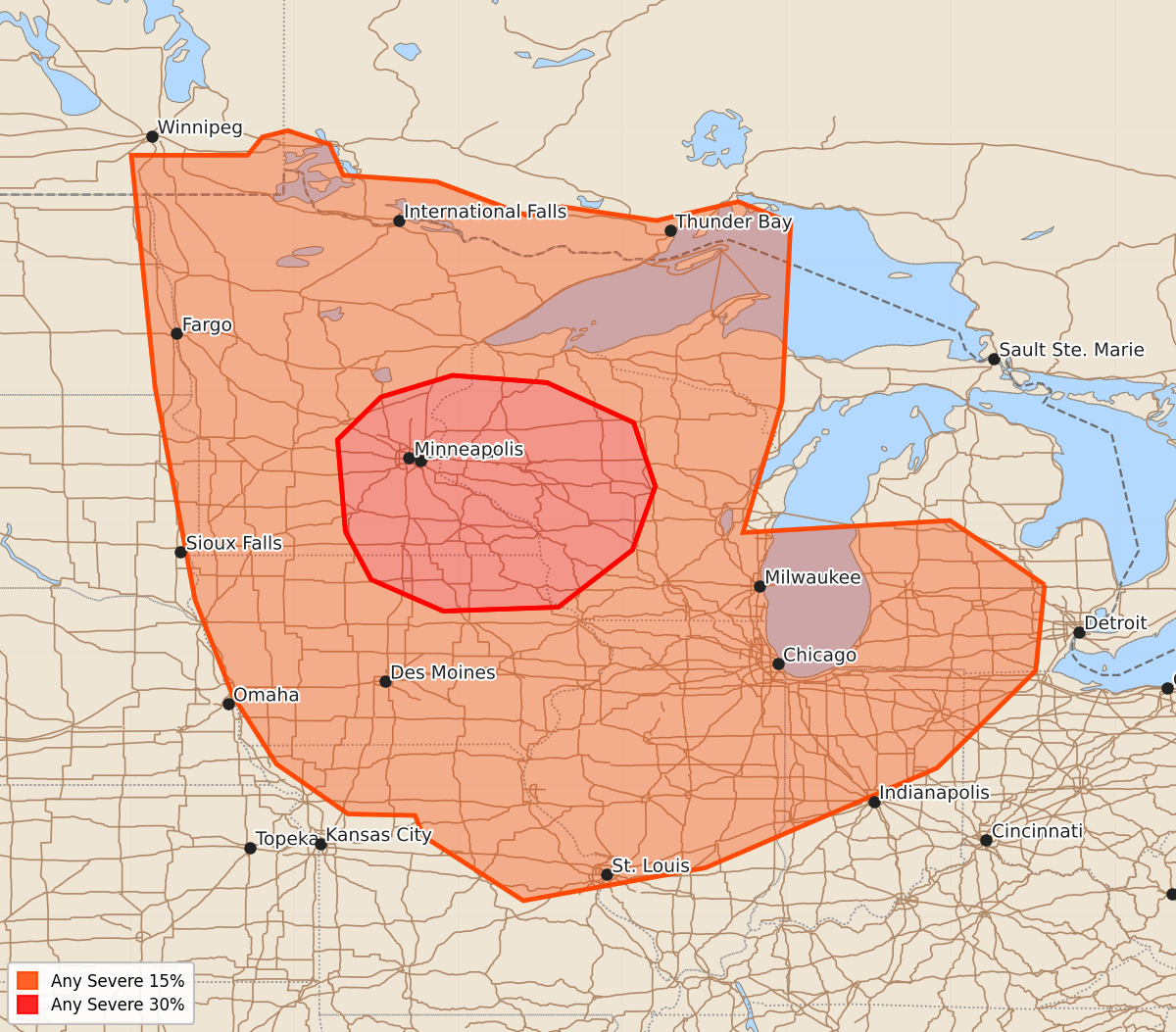
Summary
Potentially significant severe weather is expected Wednesday afternoon and evening across parts of Minnesota, Wisconsin, and Iowa. Severe storms capable of all weather hazards may also develop across the upper Midwest into the mid Mississippi Valley on Thursday afternoon and evening.
Product Text
000 ACUS48 KWNS 070843 SWOD48 SPC AC 070841 Day 4-8 Convective Outlook NWS Storm Prediction Center Norman OK 0341 AM CDT Sun Jun 07 2026 Valid 101200Z - 151200Z ...DISCUSSION... ...Day4/Wednesday... A concentrated area of potentially significant severe weather is expected Wednesday afternoon and evening, centered across portions of Minnesota, Wisconsin, and Iowa. A number of the deterministic models have trended slightly faster with the progression of a lead short-wave trough and associated jet streak through the northern Plains into upper MS Valley. At the surface, low pressure initially over eastern SD is forecast to develop northeast along a cold front moving from the eastern Dakotas into MN. The trailing extension of the boundary is expected to move more slowly into the mid MO Valley before stalling in response to a deepening cyclone over the central High Plains. Steep lapse rates and a very moist boundary layer will contribute to moderate to strong instability across the warm sector, with initial storms potentially developing by early afternoon from the Red River Valley into central MN. Subsequent storms are likely to develop across southern MN into IA and northern MO by mid to late afternoon. The models indicate 40+ kt deep-layer shear across the warm sector, supportive of supercells and bowing structures, capable of all severe-weather hazards. The severe-weather threat is expected to spread east through the upper Midwest during the evening hours. ...Day 5/Thursday... Both the ensemble mean and deterministic models indicate the development of a prominent mid-level low over Manitoba or northwest Ontario, with a potent short-wave trough moving through the base of that feature from the upper MS Valley through the upper Great Lakes. A belt of unseasonably strong mid-level winds will attend the short-wave trough from the central Plains into upper Great Lakes. At the surface, ensemble member clustering and the deterministic models indicate the primary low pressure over Ontario, with some signal for a secondary cyclone/frontal wave developing from the mid MO Valley into upper Midwest during the day. The associated surface front is forecast to advance through the upper Midwest into upper Great Lakes, with the trailing extension of the boundary moving into the mid MS Valley and southern Plains. The presence of moderate to strong instability across the pre-frontal warm sector suggests the potential for severe storms from the upper Midwest into southern Plains. Within that broader envelope, a potentially more concentrated area of severe weather may materialize from parts of the upper Midwest into mid MS Valley during the afternoon and evening hours. There, the most favorable overlap of the forcing for ascent, sufficient vertical shear, and ample instability are expected to reside. ...Day 6/Friday... The ensembles and majority of deterministic models indicate the Day5/Thursday upper Great lakes short-wave trough will lift northeast into Ontario and Quebec. At the surface, the models suggest that a weakening cold front will advance into the Northeast and through the OH Valley. Some severe-weather threat could develop along the front by afternoon; however, the models suggest that the boundary will become increasingly displaced from the strongest mid-level winds and associated vertical shear. Isolated severe storms also appear possible in the vicinity of a deepening lee cyclone over the central High Plains. ...Days 7-8/Saturday and Sunday... The ensemble mean solutions indicate some potential for mid-level troughing to develop from the northern Rockies into northern Plains next weekend, which is supported by a number of the deterministic models. At the surface, there are indications that a frontal system may stretch from the upper Midwest or Great Lakes into central High Plains, where some severe-weather threat could develop. ..Mead.. 06/07/2026