Day 1 Convective Outlook
Issued: · Valid: –
Summary
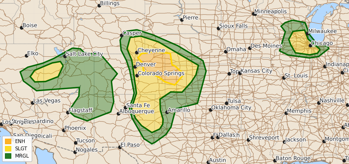
Severe thunderstorms capable of producing large hail and damaging wind gusts are expected tonight across parts of northeastern Colorado, southwestern Nebraska, and western Kansas. Additionally, severe hail and wind risks persist this evening across parts of southeastern Wisconsin, northeastern Illinois, and northwestern Indiana.
Product Text
000 ACUS01 KWNS 250101 SWODY1 SPC AC 250059 Day 1 Convective Outlook NWS Storm Prediction Center Norman OK 0759 PM CDT Wed Jun 24 2026 Valid 250100Z - 251200Z ...THERE IS AN ENHANCED RISK OF SEVERE THUNDERSTORMS TONIGHT ACROSS PARTS OF NORTHEASTERN COLORADO INTO NORTHWESTERN KANSAS... ...THERE IS A SLIGHT RISK OF SEVERE THUNDERSTORMS THIS EVENING ACROSS PARTS OF THE UPPER MIDWEST AND THE GREAT BASIN... ...SUMMARY... Scattered severe storms accompanied by large hail may gradually evolve into an organizing cluster with increasing potential to produce damaging wind gusts across parts of northeastern Colorado into parts of southwestern Nebraska and western Kansas tonight. ...01Z Update... ...Front Range into adjacent central Great Plains... Warm advection based near the 700 mb level, near the northeastern periphery of a plume of elevated mixed-layer air lingering to the east of the Front Range, is becoming the focus for increasing thunderstorm development across and east-southeast of the Cheyenne Ridge vicinity. This seems likely to continue to grow upscale during the next few hours, aided by inflow of seasonably moist boundary-layer air emanating from along and south of a stalled to slowly southwestward advancing surface front across this region through the central Nebraska/Kansas state border vicinity. Beneath 20 kt westerly deep-layer mean flow (but strongly sheared due to pronounced veering of winds from easterly to westerly with height), this activity probably will gradually organize as it propagates east-southeastward this evening, and pose increasing potential for strong to severe surface gusts. Strongest gusts and highest severe wind probabilities may eventually focus on the southwestern flank of the evolving system across parts of east central Colorado into northwest/west central Kansas, near the nose of a modest (30+ kt around 850 mb) southeasterly boundary-layer jet. ...Southern Wisconsin/Northern Illinois... Low-level moistening is maintaining boundary-layer instability in a pre-frontal corridor across west central through northeastern Illinois early this evening. As larger-scale mid-level troughing continues to slowly dig across the Upper Midwest/Great Lakes region, forcing for ascent may maintain vigorous thunderstorm development posing a risk for severe hail and wind across parts of southeastern Wisconsin/northeastern Illinois into portions of northwestern Indiana into mid to late evening. ..Kerr.. 06/25/2026 $$