Day 1 Convective Outlook
This product has been superseded. View the updated product →
Issued: · Valid: –
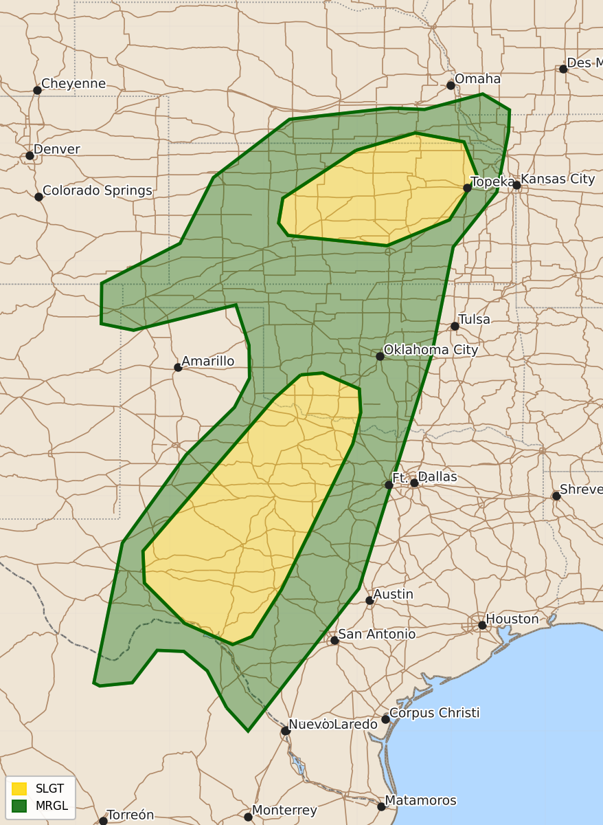
Summary
Severe thunderstorms capable of producing damaging wind gusts, hail, and brief tornadoes are expected this afternoon and tonight across parts of the southern and central Plains, including west Texas, southwest Oklahoma, Kansas, and southeast Nebraska. These storms may persist into the overnight hours across portions of central Texas and Oklahoma.
Product Text
000 ACUS01 KWNS 301258 SWODY1 SPC AC 301257 Day 1 Convective Outlook NWS Storm Prediction Center Norman OK 0757 AM CDT Wed Sep 30 2026 Valid 301300Z - 011200Z ...THERE IS A SLIGHT RISK OF SEVERE THUNDERSTORMS ACROSS PORTIONS OF THE SOUTHERN AND CENTRAL PLAINS... ...SUMMARY... Thunderstorms capable of severe wind gusts/some hail and a brief tornado are expected across the southern Plains this afternoon into tonight including portions of west Texas into southwest Oklahoma. The potential for a few tornadoes and localized wind damage will also exist across Kansas and possibly far southeast Nebraska. ...Central/southern Plains... A mid/upper-level low will move from the southern Rockies toward the central High Plains through tonight. A surface low initially over the southern High Plains is forecast to move only slowly eastward through tonight. A warm front extending northeast of the surface low may move slowly northward through the day, though persistent clouds and precipitation may hinder its advance. A rather strong low-level jet (50+ kt diurnally) is forecast to slowly shift northeastward across parts of central/eastern Kansas into western Missouri and southeast Nebraska/southwest Iowa by evening. This will help to maintain strong wind profiles in the vicinity of the central Plains effective warm front. Destabilization near the warm front may remain weak due to limited diurnal heating and weak mid-level lapse rates. While uncertainties remain regarding the disposition of persistent early day precipitation and cloud cover, will defer to the anticipated strength of 0-1km/0-3km AGL winds and related supercell-conducive profiles. Have upgraded portions of central/eastern Kansas into far southeast Nebraska with the notion that multiple tornadoes are a viable possibility, even if destabilization remains muted later today. Farther south, the coverage and persistence of early-day convection across the southern Plains remains somewhat uncertain, though there may be a tendency for convection to weaken and/or shift northward by early afternoon. The greatest confidence in substantial diurnal destabilization is from southwest Oklahoma into northwest Texas and the Edwards Plateau, where heating of a very moist airmass will result in MLCAPE increasing to near/above 1500 J/kg, despite poor mid-level lapse rates. Renewed storm development is expected from late afternoon into the evening, in advance of the approaching mid/upper-level low. Moderate mid-level flow will provide sufficient deep-layer shear for storm organization. While supercells will be possible initially, generally front-parallel flow and increasing storm coverage will likely lead to more of a linear mode with time. Strong to severe gusts appear to be the most likely hazard, though isolated hail also appears possible across southwest Texas, where somewhat stronger destabilization may occur. Also, while low-level flow will be weaker compared to areas farther north, some increase in effective SRH is expected during the evening, which could support a localized tornado threat within the very moist environment. An isolated severe threat could persist into parts of central Texas/Oklahoma overnight, though diminishing buoyancy with time and eastward extent should result in an eventual weakening trend. Elsewhere, a few strong to locally severe lower-topped storms could occur across the south-central High Plains pending sufficient destabilization. ..Guyer/Bentley.. 09/30/2026 $$