Day 3 Convective Outlook
Issued: · Valid: –
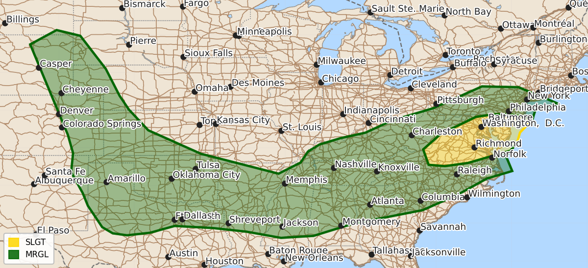
Summary
Widely scattered severe thunderstorms are possible across parts of the Mid-Atlantic on Monday afternoon and evening. Isolated severe weather may also occur Monday afternoon and evening across the southern Plains, the central and northern High Plains, and from the southern Appalachians through the Mid-South.
Product Text
000 ACUS03 KWNS 201931 SWODY3 SPC AC 201930 Day 3 Convective Outlook NWS Storm Prediction Center Norman OK 0230 PM CDT Sat Jun 20 2026 Valid 221200Z - 231200Z ...THERE IS A SLIGHT RISK OF SEVERE THUNDERSTORMS ACROSS A PART OF THE MID-ATLANTIC... ...SUMMARY... Widely scattered severe storms appear possible across portions of the Mid-Atlantic Monday afternoon and evening. More isolated severe weather is expected along a frontal zone that will extend from the southern Appalachians to the Mid-South and southern Plains, as well as across the central and northern High Plains Monday afternoon and evening. ...Synopsis... A series of mid-level disturbances initially from the Great Lakes and OH Valley into the mid-South Monday morning are expected to translate east toward the Atlantic Coast during the forecast period. A belt of stronger mid-level flow will coincide with a more prominent short-wave trough translating through the Mid-Atlantic during the day. Elsewhere, mid-level flow is forecast to strengthen across the northern and central High Plains, downstream from a short-wave trough moving through the northern High Plains. At the surface, an area of low pressure over the upper OH Valley at 12Z Monday is forecast to develop toward the Mid-Atlantic Coast by evening with a trailing cold front advancing through the central Appalachians and TN Valley into the Southeast and central Gulf Coast States. The western extension of the boundary will extend through the southern Plains into eastern NM with a strengthening upslope flow regime developing within the post-frontal environment across the central and northern High Plains. ...Mid-Atlantic... Areas of showers and thunderstorms are expected to be ongoing Monday morning across the lower Great Lakes/upper OH Valley region. Ahead of that convection, a southwesterly low-level jet is forecast to migrate through the Mid-Atlantic, enhancing the poleward transport of an increasingly moist and unstable boundary layer. Increasing height falls/forcing for ascent coupled with convergence near and ahead of the surface low, cold front, and any existing outflow boundaries are expected to foster an increase in storm coverage and intensity by afternoon. Strengthening mid-level flow aloft will combine with backed, near-ground winds ahead of the surface low to enhance vertical shear across the DelMarVa region, supporting the potential for supercell storm modes capable of all severe-weather hazards. ...Northern and central High Plains into the southern Plains... There is some model signal for a weak mid-level disturbance to overspread the northern and central High Plains Monday, ahead of a stronger short-wave trough, which will remain well upstream through the peak of the diurnal heating cycle. Forcing for ascent remains much more nebulous across the southern Plains. Thunderstorms appear possible during the afternoon within the upslope flow regime across the northern and central High Plains, as well as along the stalled synoptic front in TX and OK. Storm coverage remains uncertain, which precludes higher probabilities at this time. However, given the presence of moderate to strong instability and more-than-sufficient vertical shear for supercells, a conditional intensity group one contour has been added to the forecast. ...Southern Appalachians into the mid-South and lower Mississippi Valley... Multiple, larger-scale storm clusters may be ongoing Monday morning across the Ozark Plateau into the Mid-South. Daytime heating coupled with the presence of a very moist low-level air mass is expected to yield moderate to strong instability by afternoon ahead of the early-day storms. As such, any storms that linger through the morning may intensify by afternoon, with additional storms developing along the synoptic front and any remnant outflow boundaries. Generally weak vertical shear is expected to limit organized, severe-storm potential; however, the magnitude of instability and presence of steep low-level lapse rates will be supportive of damaging downburst winds. ..Mead.. 06/20/2026 $$