Day 1 Convective Outlook
Issued: · Valid: –
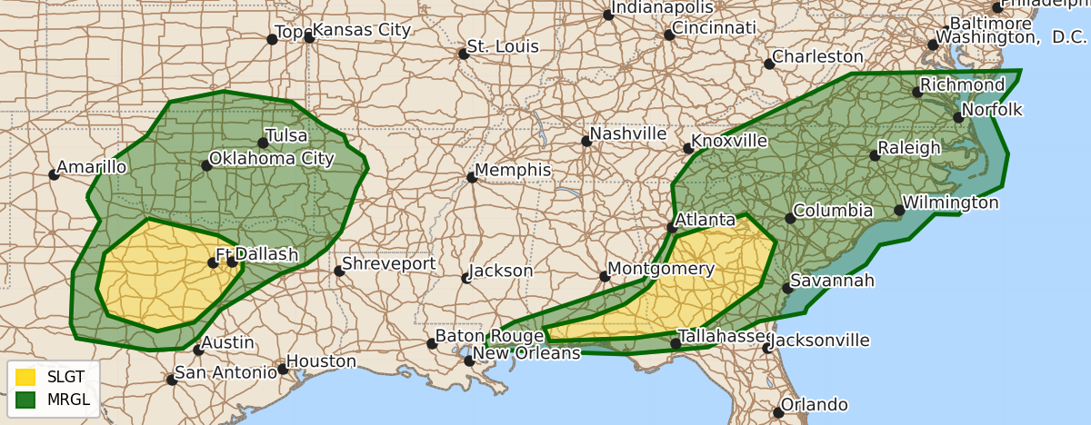
Summary
Scattered damaging winds are expected across much of north-central Texas this evening into tonight. Brief tornadoes and damaging gusts are also possible from southern Alabama through the Florida Panhandle and across Georgia later tonight.
Product Text
000 ACUS01 KWNS 190101 SWODY1 SPC AC 190059 Day 1 Convective Outlook NWS Storm Prediction Center Norman OK 0759 PM CDT Thu Jun 18 2026 Valid 190100Z - 191200Z ...THERE IS A SLIGHT RISK OF SEVERE THUNDERSTORMS OVER PARTS OF THE SOUTHEAST AND NORTH-CENTRAL TEXAS... ...SUMMARY... Isolated brief tornadoes and damaging gusts remain possible from far southern Alabama into the parts of the Florida Panhandle and across much of Georgia. Scattered damaging winds are likely this evening into tonight over much of north-central Texas. ...From far southern AL across GA and into SC... A line of thunderstorms currently extends north-south across central GA ahead of the midlevel wave. The environment is very moist and 0-1 SRH is over 250 m2/s2 at the JGX radar. Minimal CIN due to the high PWAT air mass should thus continue to support QLCS tornado potential as the line of storms moves across GA, and possibly into SC later tonight. Farther southwest, robust thunderstorms have developed near Mobile and will move eastward across far southern AL and the northern and western FL Panhandle. A very moist and unstable air mass resides here as well, and stronger westerly flow and shear around the southern periphery of the upper system will continue to support a narrow corridor of brief tornado or damaging wind potential. For more information see mesoscale discussion 1191. ...Much of north-central Texas... Hot conditions exist across the Abilene to San Angelo area this evening, with little CIN. The 00Z MAF sounding shows a deep mixed layer and over 2000 J/kg MLCAPE with a near 60 F dewpoint. Just east of the low-level lapse rate plume, dewpoints are well into the 70s F, with 3000-4000 J/kg MLCAPE into central TX. Storms are already beginning to form over west-central TX as a cold front pushes south into the storm-ready air mass. Winds around 850 mb will also increase out of the southeast tonight, aiding unstable inflow into a developing cluster of storms. Shear and steering currents aloft are weak, but severe outflow is expected to affect much of northwest into north-central TX later this evening into tonight. A general southeastward propagation is most likely, into the moist plume. Conditions appear favorable for damaging winds, and localized significant wind gusts cannot be ruled out. Given such high instability, some of the stronger storms may briefly produce hail. ..Jewell.. 06/19/2026 $$