Day 1 Convective Outlook
This product has been superseded. View the updated product →
Issued: · Valid: –
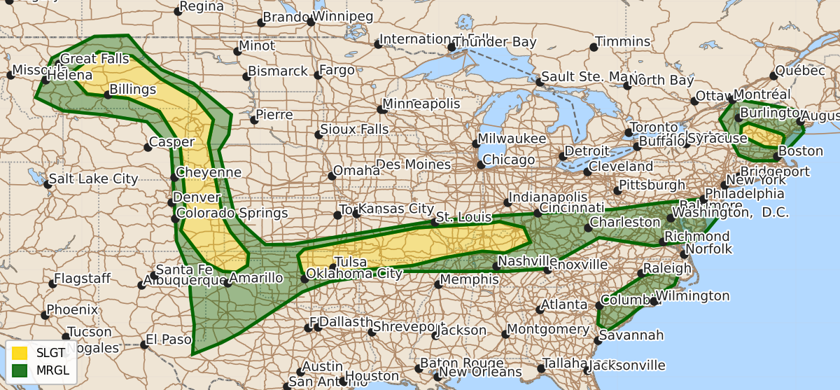
Summary
Scattered severe thunderstorms capable of producing large hail, damaging wind gusts, and possibly tornadoes are expected this afternoon through tonight across the northern and central High Plains, the southern Plains, the Lower Ohio Valley, and parts of New England. These storms will pose a slight risk of severity in these regions throughout the evening.
Product Text
000 ACUS01 KWNS 262002 SWODY1 SPC AC 262000 Day 1 Convective Outlook NWS Storm Prediction Center Norman OK 0300 PM CDT Fri Jun 26 2026 Valid 262000Z - 271200Z ...THERE IS A SLIGHT RISK OF SEVERE THUNDERSTORMS ACROSS THE NORTHERN/CENTRAL HIGH PLAINS...SOUTHERN PLAINS TO THE LOWER OHIO VALLEY...AND PARTS OF NEW ENGLAND... ...SUMMARY... Scattered severe thunderstorm development is expected today, particularly this afternoon into tonight across parts of the southern Plains to Lower Ohio Valley and across parts of the northern and central High Plains to the Black Hills vicinity. Other severe storms are expected across portions of New England. ...20Z Update... The forecast remains on track, and only minor changes were made with this update. The SLGT risk in the central High Plains was expanded southeastward from southeast CO into southwest KS and parts of the OK/TX Panhandles. Guidance is in relatively good agreement, depicting thunderstorms evolving off the Raton Mesa and tracking east-southeastward along a gradient of rich boundary-layer moisture/moderate surface-based buoyancy this evening/tonight. Aided by 40 kt of effective shear and increasing low-level hodograph curvature amid a strengthening nocturnal LLJ, supercell clusters will pose a risk for severe gusts, large hail, and possibly a tornado. Farther east, a minor westward expansion of the SLGT risk was made into north-central OK. Ample diurnal heating/destabilization of a very moist air mas (middle/upper 70s dewpoints) is yielding strong surface-based buoyancy along an east/west-oriented surface boundary. Current thinking is that a few organized clusters/supercells developing along the boundary will be capable of producing severe wind gusts and large hail later this afternoon/evening. ..Weinman.. 06/26/2026 .PREV DISCUSSION... /ISSUED 1147 AM CDT Fri Jun 26 2026/ ...Ozarks and Lower Ohio Valley... Multiple eastward-moving MCVs remain evident regionally in observational data at midday, probably strongest across southeast Missouri, but also the Oklahoma/Arkansas border vicinity and northern Kentucky. A related observed enhancement to the low/mid-level flow will persists from the Ozarks/Bootheel east-northeastward parallel to the Ohio River, but cloud cover/scattered precipitation remains fairly prevalent regionally as well. Peripheral cloud breaks and insolation should allow for gradual destabilization, particularly on the south/southwest fringes of this early day activity. This should lead to severe storm development into mid/late afternoon through the evening, potentially including supercells given the flow enhancement. A couple of tornadoes could occur aside from wind damage. ...High Plains... A seasonably anomalous upper trough will continue to amplify and spread eastward over the Pacific Northwest toward the Great Basin and Intermountain West, with a lead disturbance ejecting northeastward toward the northern High Plains. Pronounced lee troughing is forecast with a surface low expected to evolve over central and southeast Montana through tonight. A corridor of at least weak to moderate boundary-layer destabilization is expected across the High Plains. Strengthening large-scale ascent and ample vertical shear downstream of the digging large-scale troughing will favor organized severe thunderstorm development late this afternoon through evening. Supercells and evolving organized clusters will pose a risk for large hail and severe gusts, and perhaps a tornado. Across the central into southern High Plains, isolated to widely scattered storms will likely develop/mature and propagate east during the evening. Hail and wind are the primary hazards with this activity and this severe risk will probably linger into the late evening. ...New England... Have introduced a Slight Risk for portions of the region, primarily focused near the advancing surface low/warm front. A shortwave trough over Ontario/Lower Great Lakes will move east across New England by this evening. Cloud cover, albeit abating this afternoon, will limit the overall magnitude of destabilization, but upwards of 1000-1500 J/kg SBCAPE are forecast to develop along/south of a warm front. Elongated hodographs beneath a 100+ kt 250-mb speed max will aid in storm organization in the form of possibly a couple of supercells and organized multicells. Isolated coverage of large hail and damaging gusts are the primary risks with the stronger thunderstorms, but the moist environment and low-level shear/SRH could yield a tornado threat. ...Mid-Atlantic States to Carolinas... The southern periphery of stronger mid to high-level westerly flow is forecast across the region, atop northward-shifting low-level moisture that is richest across the Carolinas into southern Virginia, where near/above 70 F surface dewpoints are prevalent. The overlap of moderate westerly flow and weak destabilization is expected to support scattered thunderstorms capable of strong to locally severe/damaging gusts (50-60 mph). Additional sea-breeze influenced locally severe storms may occur across the coastal plain of the Carolinas. $$