Day 1 Convective Outlook
This product has been superseded. View the updated product →
Issued: · Valid: –
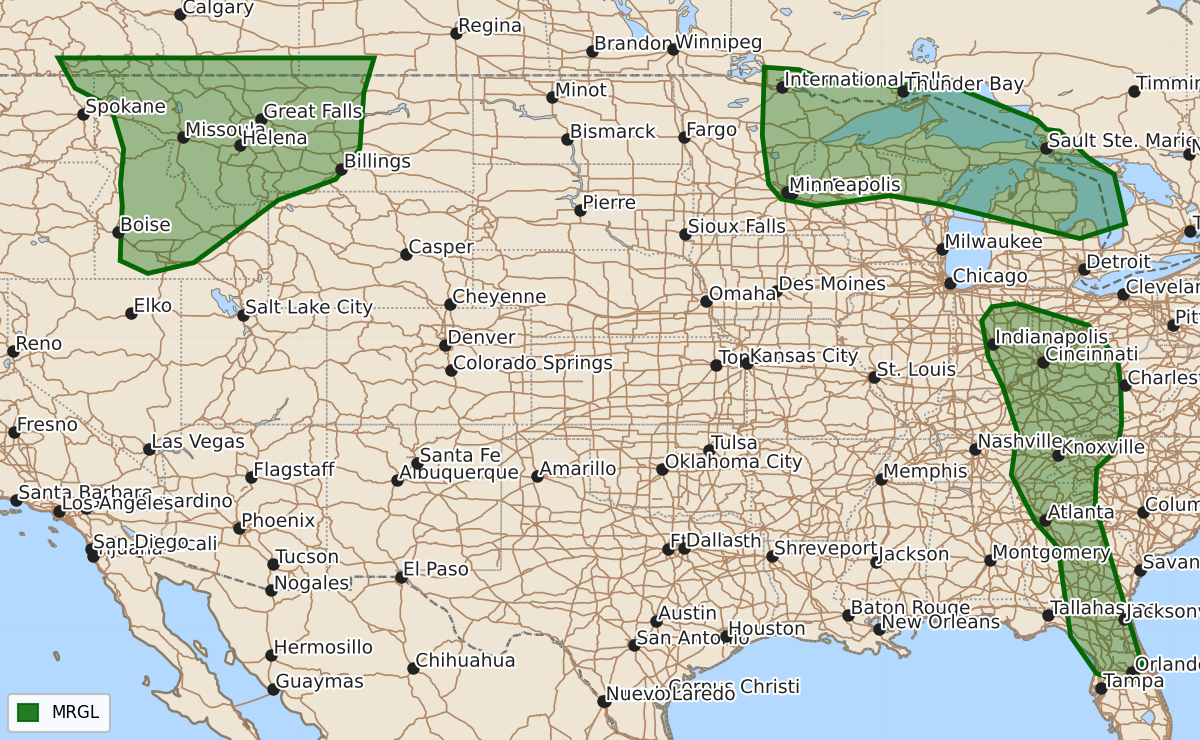
Summary
Marginal severe thunderstorms capable of producing damaging wind gusts, large hail, and brief tornadoes are possible this afternoon and evening across parts of the Northern Rockies, High Plains, Upper Midwest, and Great Lakes. Isolated strong storms with damaging winds may also develop across the Ohio Valley and Southeast later today.
Product Text
000 ACUS01 KWNS 171632 SWODY1 SPC AC 171630 Day 1 Convective Outlook NWS Storm Prediction Center Norman OK 1130 AM CDT Fri Jul 17 2026 Valid 171630Z - 181200Z ...THERE IS A MARGINAL RISK OF SEVERE THUNDERSTORMS OVER PORTIONS OF THE NORTHERN ROCKIES AND HIGH PLAINS...UPPER GREAT LAKES...AND OHIO VALLEY TO THE SOUTHEAST... ...SUMMARY... Strong to potentially severe storms are possible today across parts of western Montana and northern Idaho, and also across parts of the Upper Midwest and northern Great Lakes. More isolated strong to severe storms with damaging wind gusts are possible over parts of the Ohio Valley and Southeast. ...Northern Rockies and northern High Plains... The region will be influenced by an increasingly progressive shortwave trough moving northeastward from off the Washington coast and over southern British Columbia. The preceding upper ridge will flatten/shift eastward particularly near the international border, with a plume of rich monsoonal moisture extending into the region, highlighted by prevalent middle 50s to lower 60s F dewpoints along the Continental Divide. Orographic lift and heating will promote the development of scattered thunderstorms this afternoon, especially across eastern/northern Idaho and western Montana. Steepened low-level lapse rates will potentially yield storms capable of isolated severe wind gusts beginning this afternoon and continuing into mid-late evening. Isolated large hail may occur with the stronger thunderstorm cores, especially over northwest Montana where deep-layer shear may exceed 30 kt. ...Upper Midwest and northern Great Lakes... A decaying cluster of storms continues to spread southeastward across northern Michigan, and smoke will continue to be a factor regionally, albeit with some west-to-east abatement later today. A cold front associated with the upper wave will push southeastward across the Upper Midwest and provide a focus for thunderstorm redevelopment late this afternoon, and more so into this evening. Forecast model guidance shows moderate buoyancy developing today within a belt of 25-40 kt west-northwesterly 500-mb flow as upstream shortwave trough amplification occurs. A few of the stronger thunderstorms could evolve into supercells and organized multicell clusters, although uncertainty persists regarding the overall magnitude/extent of today's severe potential. Isolated large hail and damaging gusts are the primary hazards, although a brief tornado risk may also develop in the areas surrounding Lake Superior. One or more clusters of strong to severe storms may persist into the overnight along the warm front. ...Ohio Valley to the southern Appalachians and Florida... A moist and diurnally destabilizing airmass will support scattered to numerous storms developing by the mid afternoon. Some of the stronger water-loaded downdrafts will potentially be capable of 50-60 mph gusts and isolated wind damage. ...West-central Texas... A weak mid- to upper-level low over west Texas will move little during the day while a warm/moist conveyor persists across southern into central parts of Texas. Despite very moist low levels and some enlargement of the low-level hodograph, weak flow in the mid levels should limit storm organization and meaningful supercell potential, more so favoring a heavy rain threat. ..Guyer/Thompson.. 07/17/2026 $$