Day 1 Convective Outlook
This product has been superseded. View the updated product →
Issued: · Valid: –
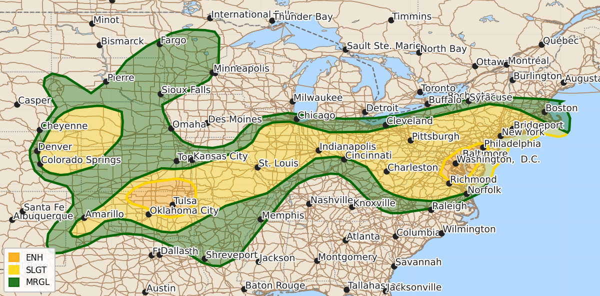
Summary
Severe thunderstorms capable of producing damaging wind gusts and large hail are expected across the southern Plains, the Mid-Atlantic, and parts of the Great Plains through this afternoon and evening. Specifically, intense wind threats are forecast for eastern Oklahoma and western Arkansas, while the Mid-Atlantic and southern New England face risks of damaging winds and hail.
Product Text
000 ACUS01 KWNS 041949 SWODY1 SPC AC 041948 Day 1 Convective Outlook NWS Storm Prediction Center Norman OK 0248 PM CDT Sat Jul 04 2026 Valid 042000Z - 051200Z ...THERE IS AN ENHANCED RISK OF SEVERE THUNDERSTORMS OVER PARTS OF THE SOUTHERN PLAINS AND MID ATLANTIC... ...THERE IS A SLIGHT RISK OF SEVERE THUNDERSTORMS OVER PORTIONS OF THE CENTRAL HIGH PLAINS AND FROM THE SOUTHERN HIGH PLAINS TO SOUTHERN NEW ENGLAND... ...SUMMARY... Clusters of storms will continue to move across parts of the Allegheny Plateau into the Mid-Atlantic, with potential for numerous damaging wind gusts. Additional severe thunderstorms are still expected across the Great Plains this afternoon and evening, posing a risk for severe wind gusts and large hail. ...20Z Update... A cold-pool-driven MCS, with a history of measured 50+ kt gusts and wind damage, continues to rapidly propagate eastward across central MO. While deep-layer shear is quite modest over the Ozarks, a pronounced baroclinic boundary is draped across central MO into the St. Louis Metropolitan area. The MCS has likely maintained its intensity thus far by riding this boundary and ingesting some vorticity for bookend vortex and rear-inflow jet maintenance. It is unclear how long this MCS will remain strong/organized given the lack of ambient deep-layer shear. However. surface temperatures on the warm side of the boundary exceeding 90 F, amid mid 70s F dewpoints, is yielding a gradient of 2500-4500 J/kg SBCAPE, which should support some severe gust threat for this MCS for at least the next few hours. As such, 30 percent wind probabilities have been added ahead of the MCS. Guidance consensus, including early depictions from WoFS output, suggests that an MCS will quickly surge southeastward across portions of the southern Plains after initiating along the KS/OK border late this afternoon. The farther southeast initiation (given the current position of the surface outflow boundary left behind from the previous MCS), and southeastward surging potential, it appears that the greatest wind threat will exist into east-central OK. 30 percent/CIG1 wind probabilities have been extended into this region. Five percent hail probabilities have been added across portions of the lower Hudson Valley. Here, MRMS mosaic MESH data suggests that marginally severe hail may already be falling with the more robust storms over northern PA. Furthermore, stronger mid-level flow is grazing the lower Hudson Valley, contributing to 30-40 kts of effective bulk shear amid 1000+ J/kg MLCAPE, which should be adequate to support a continued hail threat. Otherwise, the previous forecast remains on track, including the potential for numerous damaging to occasionally severe gusts expected across portions of the Mid Atlantic into southern New England through the afternoon and evening hours. Mostly minor adjustments have been made to the remainder of the outlook to account for guidance consensus and observations. ..Squitieri.. 07/04/2026 .PREV DISCUSSION... /ISSUED 1101 AM CDT Sat Jul 04 2026/ ...Mid Atlantic... A hot summer day is forecast across the Mid Atlantic region today with temperatures well into the 90s and dewpoints ranging from the mid 60-lower 70s F. Full sun will result in steep low-level lapse rates and high CAPE values beneath moderately strong northwest mid-level flow. Scattered thunderstorms are expected to develop along/east of the Blue Ridge and spread eastward across parts of PA/VA/NJ/DE through the late afternoon and evening. Parameters remain favorable for downburst winds in these clusters of storms. ...PA/NY into southern New England... A weak shortwave trough and associated mid level speed max is rotating southeastward out of Ontario/Quebec into the northeast US. Ample low-level moisture and pockets of moderate CAPE will result in widely scattered afternoon thunderstorm development from northern PA into central NY. These storms will spread southeastward into southern New England by early evening. The strongest cells will pose a risk of damaging wind gusts. ..IL/IN... A remnant MCV from overnight convection is analyzed over eastern IA, with a surface boundary extending eastward just south of CHI. The air mass to the south of the boundary across IL will become very unstable by mid-afternoon, leading to scattered thunderstorms. Favorable thermodynamic parameters suggest a risk of damaging winds as these storms organize and track into IN by evening. ...KS/MO... An ongoing cluster of strong/severe storms is affecting eastern KS. Given the moist and unstable air mass to the east and sufficient mesoscale organization, it is probable that this cluster will persist into the afternoon. Storms will track into western MO with a continued risk of locally damaging wind gusts. ...KS/OK/AR... In the wake of the aforementioned cluster of storms, new development is likely later this afternoon along the remnant outflow boundary across southern KS and northern OK. High CAPE values to the south of the boundary will promote the ENH risk of damaging winds and some hail as storms build southeastward across central/eastern OK and into western AR this evening. ...TX Panhandle... A weak surface boundary will be the focus for scattered late afternoon thunderstorms over the southern/eastern TX Panhandle. The strongest cells may produce damaging wind gusts and large hail for a few hours. ...Northeast CO... Southerly low level winds will maintain dewpoints in at least the 40s over parts of eastern CO this afternoon despite strong heating/mixing. This will be sufficient to allow scattered thunderstorms to form along the foothills and DCVZ. A few severe cells are possible with large hail being the main risk. ...MN/SD... Similar to yesterday, a few afternoon and early evening thunderstorms are expected to develop ahead of a weak shortwave trough. The strongest cells might produce large hail or gusty winds. $$