Day 2 Convective Outlook
Issued: · Valid: –
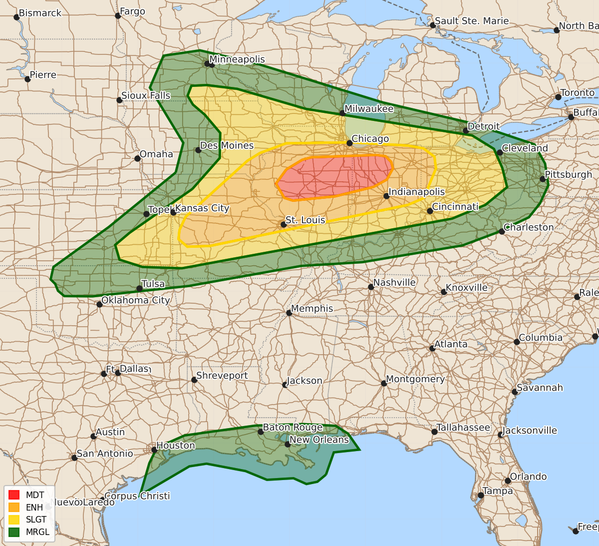
Summary
An outbreak of severe thunderstorms is expected across parts of central Illinois and northwest Indiana on Wednesday, bringing a threat of intense tornadoes, damaging wind gusts up to 80 mph, and large hail. Severe storms are also possible across parts of southeast Kansas and Missouri on Wednesday afternoon with risks of strong tornadoes, very large hail, and high winds.
Product Text
000 ACUS02 KWNS 161733 SWODY2 SPC AC 161731 Day 2 Convective Outlook NWS Storm Prediction Center Norman OK 1231 PM CDT Tue Jun 16 2026 Valid 171200Z - 181200Z ...THERE IS A MODERATE RISK OF SEVERE THUNDERSTORMS ACROSS PARTS OF CENTRAL ILLINOIS INTO NORTHWEST INDIANA... ...SUMMARY... An outbreak of severe thunderstorms is expected across portions of Illinois and Indiana on Wednesday. Intense tornadoes, swaths of damaging gusts to 80 mph and hail to 2.5 inch diameter are expected. ...Synopsis... A strong mid-level jet streak will overspread parts of the Midwest and lower Great Lakes on Wednesday. A deep surface low initially within the Upper Midwest is forecast to evolve across the lower Great Lakes and southern Ontario/Quebec. A strong low-level jet will advect rich surface moisture ahead of a cold front through the period. A warm front, likely reinforced by morning convection is expected to lift northward into parts of central/northern Illinois and northern Indiana/Ohio. Potent wind fields for this point in June will support a threat for scattered to numerous severe storms capable of all severe hazards -- including strong to intense tornadoes, very-large hail, and 75+ mph winds. ...Mid-Mississippi Valley into northern Indiana/far western Ohio... A majority of the CAMs as well as regional/global guidance suggest convection will be ongoing in parts of eastern Iowa early Wednesday morning. This activity will shift through northern/central Illinois into Indiana. Some risk for damaging winds will probably accompany this activity. The degree to which this cluster of convection can intensify through mid/late morning is not clear. The environment with eastward extent will begin drier and less unstable. The most probable outcome is that this convection shifts east-southeast relatively quickly and weakens with time. The more substantial severe threat is expected to develop perhaps by early/mid afternoon and depend strongly upon how morning convection evolves spatially. Given the strong moisture advection into the region, it is reasonable to expect an area of relatively rapid airmass recovery from the Quad Cities vicinity into parts of central Illinois. Storms that form in this environment near the surface low/warm front will likely be discrete and take advantage of strong low-level shear. Large to very-large hail, significant wind gusts, and strong/intense tornadoes will all be possible. As convection continues eastward into Indiana, the low-level moisture will be improving with time. ...Southeast Kansas into Missouri... Along the cold front, scattered storms are expected to develop by mid/late afternoon. With mid-level height falls not being overly strong and effective shear vectors have a large orthogonal component across the front, storms will likely be supercellular for a few hours. Steep mid-level and low-level lapse rates will promote a risk of large/very-large hail as well as potentially 75+ mph wind gusts. Despite being west of the low-level jet core, low-level wind fields will still support a risk of tornadoes, some of which could be strong. ...Central Gulf Coast... Potential Tropical Cyclone 1 is forecast to move northeastward with time. The marginally enhanced low-level wind fields will support weak supercell structures that may produce brief, weak tornadoes. Given the poor thermodynamic environment and the main timing of the threat being during the evening/overnight, the overall threat should remain marginal. ..Wendt.. 06/16/2026 $$