Day 3 Convective Outlook
Issued: · Valid: –
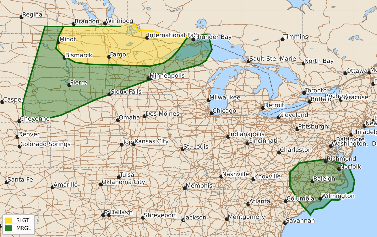
Summary
Severe thunderstorms capable of producing large hail and damaging winds are possible across parts of the northern Plains and Upper Midwest on Sunday. Isolated damaging winds may also occur across parts of the southern Mid-Atlantic through early Sunday evening.
Product Text
000 ACUS03 KWNS 261917 SWODY3 SPC AC 261916 Day 3 Convective Outlook NWS Storm Prediction Center Norman OK 0216 PM CDT Fri Jun 26 2026 Valid 281200Z - 291200Z ...THERE IS A SLIGHT RISK OF SEVERE THUNDERSTORMS ACROSS PORTIONS OF NORTH DAKOTA AND THE UPPER MIDWEST... ...SUMMARY... Severe thunderstorms are possible from the northern Plains into parts of the Upper Midwest on Sunday. Large hail and severe winds are the primary hazards. ...Synopsis... The western U.S. upper trough will deepen and persist over that region on Sunday. Meanwhile, upper ridging will intensify over the Midwest into the South, while a shortwave upper trough moves from the Ohio Valley to the southern Mid-Atlantic region. At the surface, some uncertainty persists with regards to the location of lee surface low development in the central or northern Plains. The NAM appears to be an outlier compared to the ECMWF/GFS and the AI versions thereof. This will be important for where the best corridor of severe thunderstorm potential develops on Sunday afternoon/evening. Further east, a surface front will sag southward across the Upper OH Valley and portions of the Mid-Atlantic. Between these surface boundaries, a seasonally very moist airmass will exist across at least eastern portions of the Plains to the MS Valley and the southern Mid-Atlantic. ...Northern Plains/Upper Midwest vicinity... The forecast for Sunday is highly uncertain. Forecast guidance suggests a shortwave impulse and/or MCV will move across northern MN during the afternoon/evening. This area will be beneath the upper ridge axis and could be capped. However, a very moist airmass will be in place beneath steep midlevel lapse rates. Furthermore, a strong southerly low-level jet is expected to focus from the central Plains to the Upper MS Valley during the evening/nighttime hours. If storms can develop and become near-surface based, potential for damaging wind gusts and large hail will be possible. This scenario is generally supported by the RRFS and GSL MPAS, though location/timing varies. Forecast guidance develops additional areas of convection across portions of western NE/central SD into ND on the western periphery of stronger capping and near the surface trough/dryline within the gradient of stronger instability. This scenario is uncertain, both regarding storm development, and if storms occur, whether or not they will be surface-based. However, if storms do develop, an intense low-level jet within the strongly unstable airmass during the evening/overnight hours could support damaging wind potential. The Marginal risk (level 1 of 5) has been adjusted to reflect this conditional risk. ...Southern Mid-Atlantic... Forecast guidance suggests an MCV will move across the central Appalachians into parts of VA/NC on Sunday. Deep-layer flow is not expected to be particularly strong, but this feature could locally enhanced vertical shear, with some guidance showing effective shear magnitudes up to 25 kt are possible. A seasonally very moist airmass will reside east of the higher terrain across southeast VA into the eastern Carolinas, supporting moderate destabilization as strong daytime heating occurs. Thunderstorms will pose an isolated damaging wind risk into early evening. ..Leitman.. 06/26/2026 $$