Day 3 Convective Outlook
Issued: · Valid: –
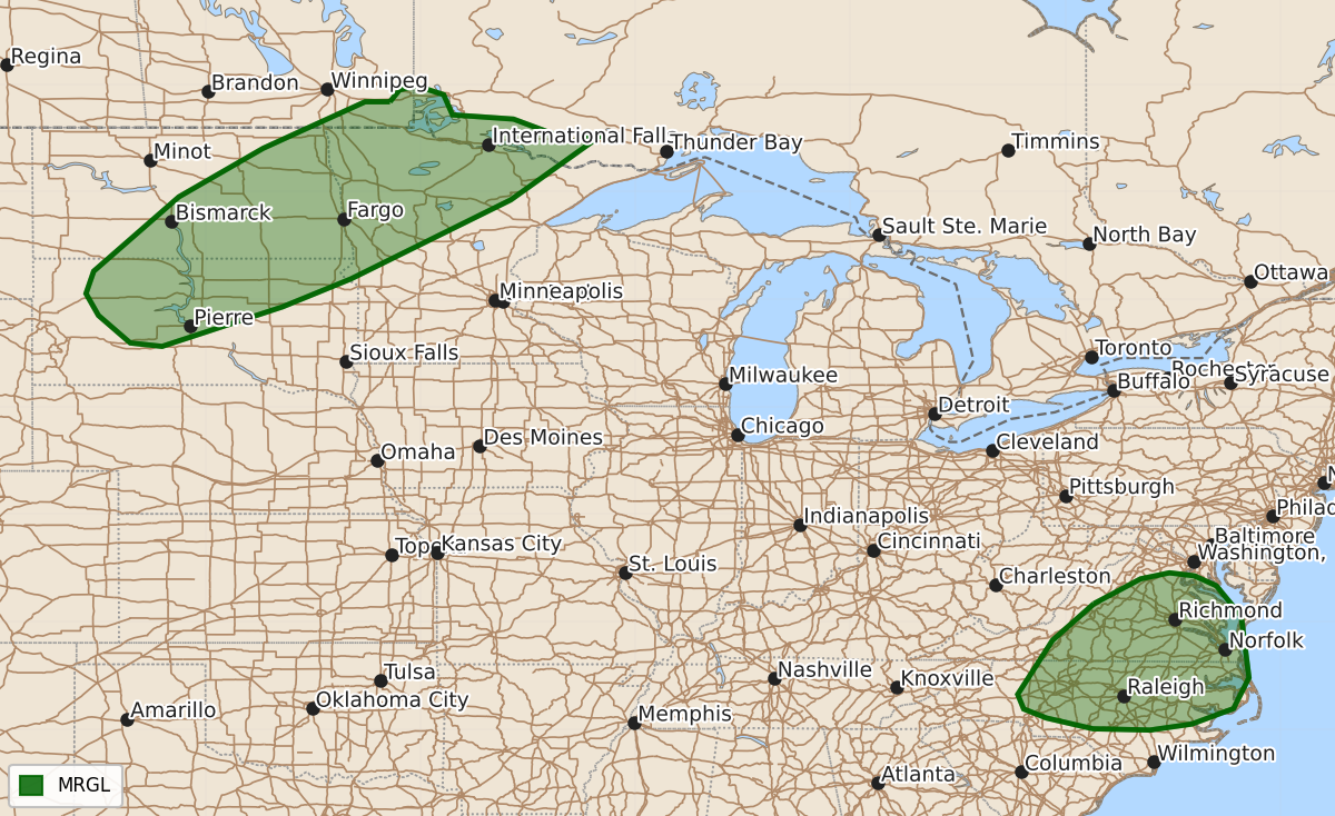
Summary
Strong to severe thunderstorms are possible Monday afternoon and evening across portions of the northern Plains, Minnesota, and the southern Mid-Atlantic. These storms may bring wind damage, large hail, and severe gusts.
Product Text
000 ACUS03 KWNS 041856 SWODY3 SPC AC 041855 Day 3 Convective Outlook NWS Storm Prediction Center Norman OK 0155 PM CDT Sat Jul 04 2026 Valid 061200Z - 071200Z ...THERE IS A MARGINAL RISK OF SEVERE THUNDERSTORMS ACROSS PARTS OF THE NORTHERN PLAINS INTO MINNESOTA...AND THE SOUTHERN MID-ATLANTIC... ...SUMMARY... Strong to severe thunderstorms are possible Monday afternoon and evening across portions of the southern Mid-Atlantic and the northern Plains. ...VA/NC vicinity... Upper troughing over the Midwest will continue to slowly shift east toward the Appalachians on Monday. Modest deep-layer southwesterly flow will overspread the central Appalachians to the Mid-Atlantic vicinity as a surface low develops in the vicinity of WV. A surface boundary/cold front will sag southward across PA while surface troughing develops in the lee of the VA/NC mountains. A very moist airmass will persist and moderate destabilization is forecast. Thunderstorm clusters will once again develop and pose a risk for sporadic wind damage Monday afternoon into early evening. ...Northern Plains into northwest MN... An upper shortwave trough will move east across the Canadian Prairies, glancing the U.S. northern Plains vicinity. This will bring a band of enhance mid/upper westerly flow across the region while a surface cold front develops southeast through the afternoon and nighttime hours. Southerly low-level flow will transport 60s dewpoints northward ahead of the front beneath modestly steep midlevel lapse rates. This will support moderate to strong destabilization. It is uncertain how far south convection may develop as large-scale ascent weakens into South Dakota and capping increases. However, supercell wind profiles are evident in forecast soundings, and where storms do develop, an accompanying risk for severe gusts and large hail is possible. An upgrade to Slight risk (level 2 of 5) may be needed in subsequent outlooks if confidence in storm coverage increases. ..Leitman.. 07/04/2026 $$