Day 3 Convective Outlook
This product has been superseded. View the updated product →
Issued: · Valid: –
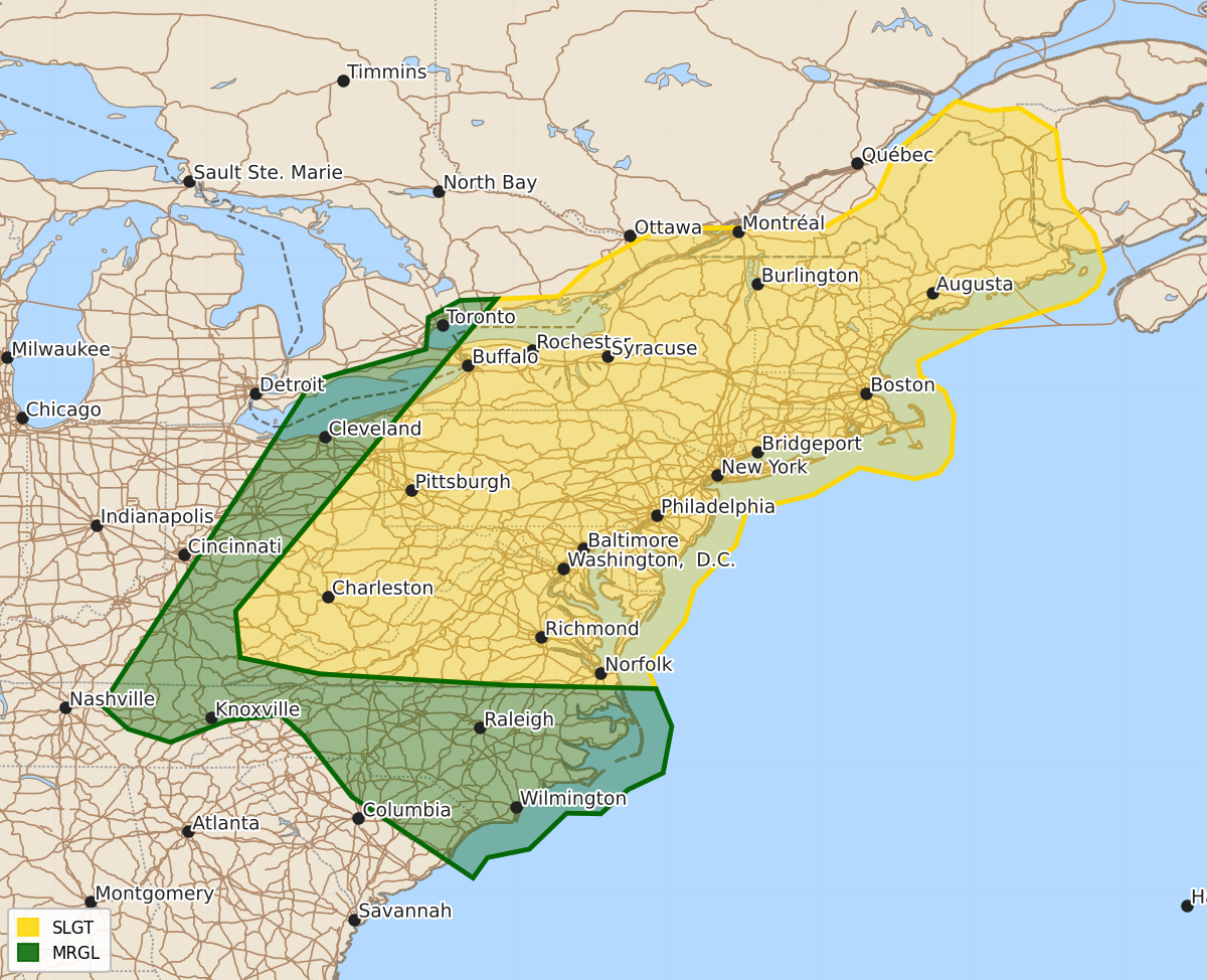
Summary
Scattered severe thunderstorms capable of producing damaging winds and large hail are possible across the Mid-Atlantic into the Central Appalachians on Friday afternoon and evening.
Product Text
000 ACUS03 KWNS 100726 SWODY3 SPC AC 100725 Day 3 Convective Outlook NWS Storm Prediction Center Norman OK 0225 AM CDT Wed Jun 10 2026 Valid 121200Z - 131200Z ...THERE IS A SLIGHT RISK OF SEVERE THUNDERSTORMS ACROSS THE MID-ATLANTIC INTO CENTRAL APPALACHIANS... ...SUMMARY... Scattered severe storms capable of damaging winds and some large hail are possible across the Mid-Atlantic into Central Appalachians Friday afternoon and evening. ...Synopsis... A short-wave trough over the upper Great Lakes and OH Valley Friday morning will progress through southwest Ontario to along the St. Lawrence Valley, with a corridor of height falls and stronger mid-level winds overspreading the lower Great Lakes into Mid-Atlantic. At the surface, a cold front will move through the lower Great Lakes and central Appalachians before merging with lee troughing east of the northern and central Appalachians. ...Mid-Atlantic into Central Appalachians... A hot and moist air mass is expected to exist across the pre-frontal warm sector Friday afternoon with temperatures in the upper 80s to upper 90s and dewpoints in the 60s to low/mid 70s. While mid-level lapse rates are expected to remain modest, the high theta-e boundary layer will largely contribute to moderate instability. The glancing influence of the short-wave trough coupled with convergence along the cold front and lee trough, in addition to terrain influences are expected to foster scattered to numerous thunderstorms through the peak of the diurnal heating cycle. The strongest vertical shear of 30-40 kt is forecast from the lower OH Valley into the lower Great Lakes, where the potential will exist for some transient supercell and bowing structures capable of large hail and damaging winds. Vertical shear will be comparatively weaker along the lee trough; however, both low-level lapse rates and instability will be greater, supporting potential for damaging downburst winds and marginally severe hail. There is some model signal that storms will coalesce into multiple clusters by late afternoon into early evening with a potentially more concentrated area of damaging winds reaching the Mid-Atlantic Coast. ...Mid-South into the Central and South High Plains... Moderate to strong instability is forecast south of the surface front, which is expected to stall across the discussion area. In the absence of appreciable forcing for ascent, the models vary on the location and coverage of diurnally enhanced storms, which could pose some severe-weather threat. Severe-weather probabilities may eventually be added to some of the area once confidence in storm evolution becomes more clear. ..Mead.. 06/10/2026 $$