Day 2 Convective Outlook
This product has been superseded. View the updated product →
Issued: · Valid: –
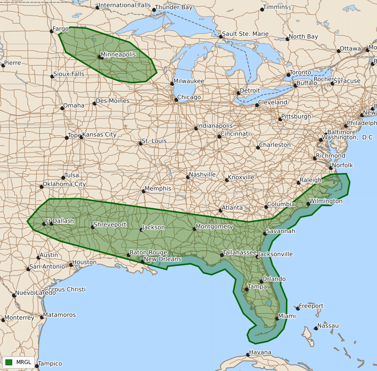
Summary
Marginal severe thunderstorms are expected on Friday across parts of the Upper Midwest, the Southeast, and from North Texas through the Gulf Coast. These storms may produce damaging wind gusts and hail, with some isolated strong storms possible in the Upper Midwest and across the Gulf Coast and coastal Carolinas.
Product Text
000 ACUS02 KWNS 180526 SWODY2 SPC AC 180524 Day 2 Convective Outlook NWS Storm Prediction Center Norman OK 1224 AM CDT Thu Jun 18 2026 Valid 191200Z - 201200Z ...THERE IS A MARGINAL RISK OF SEVERE THUNDERSTORMS ACROSS PORTIONS OF THE UPPER MIDWEST...AND FROM NORTH TEXAS THROUGH THE SOUTHEAST... ...SUMMARY... Isolated strong storms may produce gusty winds and hail across the Upper Midwest. Additional strong thunderstorms may produce damaging wind gusts from north Texas/southern Oklahoma through portions of the Gulf Coast states and into the coastal Carolinas. ...Minnesota/Wisconsin... An upper shortwave trough will migrate across the Upper Midwest on Friday. This will bring a belt of enhanced northwesterly flow aloft across the region. In the wake of a prior frontal passage, boundary-layer moisture will be very modest (generally 50s F dewpoints), but cool temperatures aloft and midlevel lapse rates near 7 C/km will support weak destabilization (around 500-1000 J/kg MLCAPE). Forecast soundings show vertically veering wind profiles and elongated/straight hodographs with around 35-40 kt effective shear magnitudes. Isolated higher-based supercells will be possible. Steepened low-level lapse rates and the relatively dry boundary-layer will support isolated strong gusts. Isolated marginally severe hail also will be possible. ...ArkLaTex vicinity through the Gulf Coast states... Most forecast guidance depicts an ongoing MCS across North Texas or far southern OK at Friday morning. Strong gusts will be possible with this system through the morning given modestly enhanced mid/upper flow and a corridor of strong instability across the ArkLaTex vicinity. This MCS and/or remnant MCV may continue east/southeast across east TX or toward the lower MS Valley through the day, tracking along a southward-sagging surface boundary. Further east across the Gulf Coast vicinity, a very moist airmass will be in place, with PW values near 2 inches common. This will aid in moderate destabilization ahead of a west to east oriented surface boundary. Vertical shear will be weak, but water laden downdrafts could support isolated microbursts. It is unclear if convection will be able to organize along the surface boundary into a forward propagating cluster, but if this occurs, damaging wind potential would increase. ...Coastal Carolinas... A mid/upper shortwave trough will move across the area through afternoon. Some guidance depicts a small MCS or cluster associated with a strong low-level jet during the morning. As this feature spreads northeast along the coast through afternoon, strong gusts will be possible. ...Florida... A seasonally moist and unstable airmass will reside across north/central FL on Friday. Parts of the state will be on the southern fringes of stronger mid-level flow associated with the upper shortwave trough moving across the Carolinas. Some forecast soundings show 20-30 kt midlevel low, and this may be sufficient for transient organized cells along parts of the east coast. Additional storms will be possible across the Panhandle and northern FL as convection develops southward across the area ahead of a southward-sagging surface boundary. Ample moisture/high PW values and moderate instability will support occasional strong gusts with the strongest storms. ..Leitman.. 06/18/2026 $$