Day 2 Convective Outlook
This product has been superseded. View the updated product →
Issued: · Valid: –
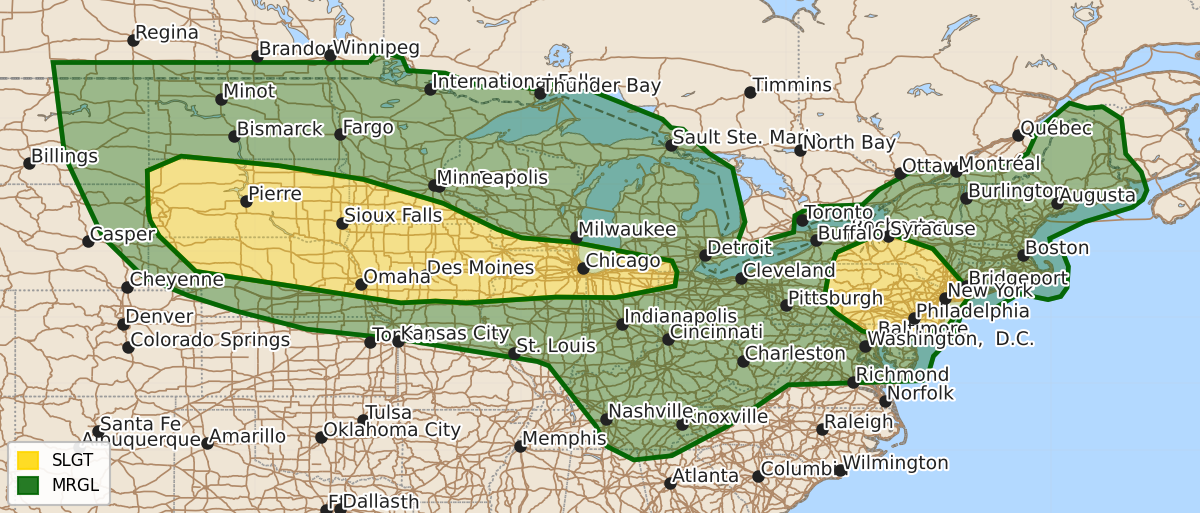
Summary
Isolated to scattered severe thunderstorms are possible on Friday across the northern and central Plains, Midwest, Tennessee Valley, and Mid-Atlantic. Expected hazards include large hail, damaging wind gusts, and an isolated risk of tornadoes.
Product Text
000 ACUS02 KWNS 020602 SWODY2 SPC AC 020600 Day 2 Convective Outlook NWS Storm Prediction Center Norman OK 0100 AM CDT Thu Jul 02 2026 Valid 031200Z - 041200Z ...THERE IS A SLIGHT RISK OF SEVERE THUNDERSTORMS FROM THE BLACK HILLS VICINITY INTO PARTS OF THE MIDWEST AND LOWER GREAT LAKES... ...SUMMARY... Isolated to scattered severe storms are possible from the northern/central Plains into the Midwest, Tennessee Valley, and Mid-Atlantic on Friday. ...Synopsis... Upper-level ridging will begin to flatten and spread westward on Friday. Modest southwesterly flow aloft will continue across much of the Rockies. In the East, stronger cyclonic flow aloft will continue in New England and the northern Mid-Atlantic. A surface low will deepen in parts of the central High Plains. A quasi-stationary/outflow composite boundary will be situated within the central/northern Plains into the Lower Great Lakes region. ...Black Hills vicinity into Mid-Missouri/Mississippi Valleys... Forecast uncertainty remains with respect to how convection evolves Thursday night into early Friday morning. Some convection could linger in parts of South Dakota and possibly Nebraska. At the very least, portions of the central/northern Plains will be impacted by outflow from earlier convection. The position of the outflow will determine where the greater severe threat develops during the afternoon. Modest southwesterly flow aloft will drive the development of the lee trough that will advect upper 50s to low 60s F dewpoints into the High Plains. A subtle shortwave trough depicted in most guidance will initiate convection within the higher terrain of eastern Montana/Wyoming and the Black Hills. Initial supercells will be capable of large to very large hail and severe winds. Additional convection is also possible farther southeast along the outflow boundary where a weak surface low may enhance low-level lift of a weakly capped airmass. A similar threat for large/very large hail and severe winds would accompany this activity. Should the activity farther east remain discrete into early evening, a marginally greater tornado risk would exist. Between these two zones of convection, upscale growth will allow one or more MCS to develop and track along the boundary. The lead MCS would have greater potential for severe winds (some 75+ mph). The low-level jet response during the evening will not be overly strong, but it should be enough to help convection to continue into parts of Iowa later in the evening. ...Northern Illinois into northwest Ohio... With an MCV and related convection likely moving through the Great Lakes region to the north, an outflow/theta-e boundary will settle somewhere within these areas. Model guidance suggests that heating along this boundary will promote scattered storm development. Modest enhancement to deep-layer shear due to the MCV may allow for modest organization of a cluster/linear segment that travels east along the boundary. Wind probabilities have been increased to account for this potential. ...Mid-Atlantic... Model spread still exists as to where the greatest storm coverage will exist during the afternoon. Temperatures nearing 100 F and 60s F dewpoints will support strong destabilization across the region. The degree of temperature-dewpoint spreads will promote efficient downdraft production. Effective shear will be greatest in the northern Mid-Atlantic where around 30 kt of flow at 500 mb will exist. This should promote clusters/linear segments capable of wind damage. Towards the Blue Ridge, storm coverage is much less certain given the very weak forcing. Damaging downbursts are still possible with storms that can develop. Model trends will continue to be monitored for any increase in expected storm coverage. ...Tennessee Valley into Ohio Valley... Strong heating of a mid/upper 60s F dewpoint airmass will promote 4000+ J/kg MLCAPE by the afternoon. Weak shear will limit storm organization, but subtle shortwave troughs moving around the upper anticyclone could allow for locally greater storm coverage/clustering. Damaging downburst winds are the expected hazard. ...Northern Plains into Upper Midwest... Forecast uncertainty remains medium to high in terms of how much destabilization will occur within these areas. Guidance generally suggests convection/cloud cover will exist during the morning and potentially parts of the afternoon. A broad marginal remains in place for damaging winds and isolated large hail potential should enough destabilization occur. ..Wendt.. 07/02/2026 $$