Day 1 Convective Outlook
This product has been superseded. View the updated product →
Issued: · Valid: –
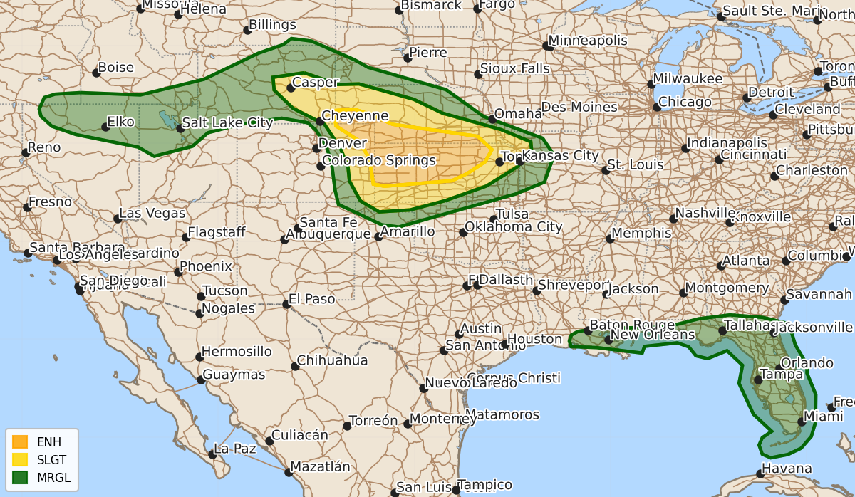
Summary
Severe thunderstorms are likely across parts of the central High Plains this afternoon and evening, with the potential for large hail, damaging winds, and a few tornadoes. Scattered thunderstorms with a risk of damaging wind gusts are also expected across the Southeast and parts of the Great Basin throughout the afternoon.
Product Text
000 ACUS01 KWNS 201959 SWODY1 SPC AC 201957 Day 1 Convective Outlook NWS Storm Prediction Center Norman OK 0257 PM CDT Sat Jun 20 2026 Valid 202000Z - 211200Z ...THERE IS AN ENHANCED RISK OF SEVERE THUNDERSTORMS ACROSS PARTS OF THE CENTRAL PLAINS... ...SUMMARY... Severe thunderstorms remain likely across parts of the central Plains mainly this afternoon and evening. Large to very large hail, severe winds (some 75+ mph), and a few tornadoes are possible. ...20z Update WY/NE/CO/KS... Scattered severe storms are likely over much of the central High Plains this afternoon and evening. Incipient convection is developing over the higher terrain/foothills and should spread eastward into a moist and destabilizing air mass. Aided by strong ascent from an upper trough and mid-level jet (observed via 18z RAOBs), supercells and organized clusters remain likely. All hazards are expected, with a focus for a few more persistent supercells and a strong tornado or two along a notable differential heating axis in southwestern NE. With time upscale growth into and MCS is likely tonight with a risk for damaging winds into the central Plains. Minor adjustments were made to the probabilities for the latest observed trends. For short term information see MCD #1212. ...Great Basin... Scattered thunderstorms have developed over parts of NV and southern ID along a diffuse frontal zone. While moisture is limited, enough instability beneath the passing upper trough will support the potential for a few severe gusts. 5% wind probabilities were extended westward. See MCD #1213 for more info. ...Southeast... Scattered to widespread thunderstorms continue across much of the Gulf Coast and Southeast States this afternoon. Sporadic damaging gusts remain possible with the stronger clusters across northern FL and southern LA. Weak shear will preclude much if any storm organization. 5% wind probabilities were adjusted to better match damaging wind potential. ..Lyons.. 06/20/2026 .PREV DISCUSSION... /ISSUED 1109 AM CDT Sat Jun 20 2026/ ...Central Plains... Water vapor imagery shows a shortwave trough over ID/UT tracking eastward toward the central High Plains. Southerly/southeasterly low-level winds ahead of this feature over parts of eastern CO/western NE/KS will help to maintain a moist and moderately unstable air mass across the region, especially as low clouds continue to burn off and afternoon heating commences. Scattered thunderstorm development is expected by mid-afternoon over central WY down into central CO in favored terrain/convergence areas. This activity will spread eastward into a progressively more moist/unstable air mass and intensify into supercells. A corridor of favorable vertical shear will develop later today from northeast CO into southwest NE/northwest KS for isolated tornadoes. Otherwise, very large hail and damaging winds will be the main concerns. Activity is likely to organize upscale during the evening and spread across KS with a damaging wind risk persisting much of the night. ...Southeast... A very moist and moderately unstable air mass is present again today over much of the southeast US. Most CAM solutions suggest scattered afternoon thunderstorms across this area, including along the FL east coast. Dewpoints in the 70s and PWAT values around 2 inches, coupled with strong daytime heating and steep low-level lapse rates suggest a risk of locally gusty/damaging wind gusts in the most intense cores. $$