Day 1 Convective Outlook
This product has been superseded. View the updated product →
Issued: · Valid: –
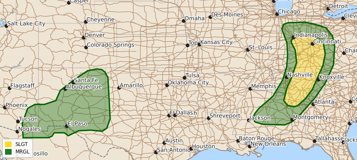
Summary
Severe thunderstorms capable of producing damaging wind gusts and an isolated tornado threat are expected across parts of the Ohio and Tennessee Valleys this afternoon and evening. Isolated severe wind gusts are also possible in parts of New Mexico, southeast Arizona, and far West Texas throughout the afternoon and evening.
Product Text
000 ACUS01 KWNS 011957 SWODY1 SPC AC 011956 Day 1 Convective Outlook NWS Storm Prediction Center Norman OK 0256 PM CDT Sat Aug 01 2026 Valid 012000Z - 021200Z ...THERE IS A SLIGHT RISK OF SEVERE THUNDERSTORMS ACROSS PARTS OF THE OHIO AND TENNESSEE VALLEYS... ...SUMMARY... Thunderstorms with severe wind gusts and an isolated tornado threat are expected across parts of the Ohio and Tennessee Valleys this afternoon into evening. Isolated severe wind gusts will also be possible in parts of New Mexico, southeast Arizona, and far West Texas. ...20Z Update... The MRGL Risk/5-percent wind probabilities were expanded westward into parts of central MS, where a very warm and moist PBL (upper 70s dewpoints) are contributing to moderate-strong surface-based buoyancy. Any thunderstorm clusters that evolve along/ahead of the approaching cold front will pose a risk of locally damaging wind gusts later this afternoon and evening. Elsewhere, the forecast remains on track, and only minor adjustments were made. ..Weinman.. 08/01/2026 .PREV DISCUSSION... /ISSUED 1116 AM CDT Sat Aug 01 2026/ ..OH and TN Valleys... Recent satellite imagery shows a positively tilted shortwave trough moving through the Mid MS Valley. Surface analysis shows an occluded surface low over central IL beneath the shortwave. Expectation is for this cyclone to drift slowly east-southeastward throughout the day, with the surface low gradually filling. As this low fills, the triple point low, currently near the IL/IN/KY border intersection, will become more prominent through the afternoon before it too occludes. Showers and thunderstorms are currently ongoing from eastern IN/western OH through eastern TN into AL, along the eastern periphery of an arcing warm conveyor. These showers and thunderstorms should continue northeastward/eastward as the entire system drifts east-southeastward, with some modest moisture advection anticipated throughout the warm sector. This should allow the warm sector to at least moderately destabilize, but persistent cloudiness will limit heating, likely tempering the overall buoyancy. Expectation is for more modest buoyancy (i.e. MLCAPE around 500 to 1000 J/kg) across IN and OH, with greater buoyancy (i.e. MLCAPE around 1500 J/kg) farther south across central KY and Middle TN. Thunderstorm development is anticipated along and ahead of the cold front as it moves through this destabilized and buoyant airmass. Moderate mid-level flow throughout the base of the Mid MS Valley shortwave trough will spread eastward across KY and TN, supporting effective shear around 30 to 35 kt across KY. Reduced vertical shear is expected farther north across the OH Valley (due to weaker mid-level flow) and farther south across TN Valley (due to more westerly low-level flow). Given these kinematic conditions, a predominantly multicellular mode is favored, although a few supercells appear possible from southeast IN/southwest OH through central KY. Damaging wind gusts will be the most prominent hazard, but a tornado or two is also possible, particularly within the corridor from far southeast IN through far north-central KY and far southwest OH. Here, some modestly increased low-level shear is possible near the triple point low as it moves through. ...Eastern AZ through NM into west TX... Moderate mid-level moisture will support afternoon thunderstorm development across the higher terrain from western AZ through central/northeast NM. Relatively strong northerly winds aloft will aid storm organization/clustering as storms spread south-southeastward into the deeply mixed boundary-layer across the lower elevations. Outflow-dominant storm structures will result in strong cold pools capable of isolated strong to severe wind gusts. Resulting forward-propagating lines could reach as far south/southeast as Far West TX by later this evening. $$