Day 3 Convective Outlook
This product has been superseded. View the updated product →
Issued: · Valid: –
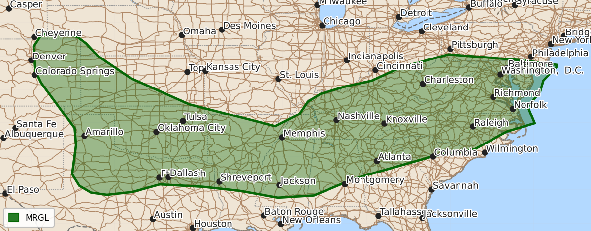
Summary
Isolated strong to severe thunderstorms are expected on Monday across the central and southern Plains, the Mid-South, and the Carolinas and Mid-Atlantic. These storms, which may bring damaging winds and a localized tornado threat, are forecast to occur during the afternoon and evening.
Product Text
000 ACUS03 KWNS 200739 SWODY3 SPC AC 200738 Day 3 Convective Outlook CORR 1 NWS Storm Prediction Center Norman OK 0238 AM CDT Sat Jun 20 2026 Valid 221200Z - 231200Z ...THERE IS A MARGINAL RISK OF SEVERE THUNDERSTORMS FROM THE CENTRAL HIGH PLAINS AND SOUTHERN PLAINS TO THE MID-SOUTH AND INTO THE CAROLINAS AND MID-ATLANTIC.... CORRECTED FOR CAPITALIZATION IN THE SUMMARY ...SUMMARY... Isolated strong to severe storms are expected along a frontal zone that extends from the mid-Atlantic to the Mid-South and southern Plains and into the central High Plains on Monday. ...Synopsis... A flat ridge is forecast across the western CONUS with broad cyclonic flow from the southern Plains to the Mid-Atlantic. Within this zone, several embedded mid-level shortwave troughs are expected, the strongest of which will move from the Ohio Valley to the Mid-Atlantic during the day Monday. A weak surface low will likely be associated with this lead shortwave trough with an additional lee trough, likely across the southern High Plains. A frontal zone will extend between these 2 features and act as the primary focus for storm development through the period on Monday. ...Central/southern Plains... A MCS should be ongoing at the beginning of the period across parts of Oklahoma on the nose of the low-level jet. An outflow boundary will likely extend westward from this MCS into parts of Northwest Texas and into the Texas Panhandle. Very strong to extreme instability is forecast across the southern Plains on Monday with dewpoints in the mid to upper 70s and steep lapse rates. Model guidance is consistent showing a weak mid-level shortwave trough emerging across the southern Plains by 00Z Tuesday with 30 to 35 knots of mid-level flow. The combination of this shortwave trough and the potential for an outflow boundary intersecting the dryline may result in a more focused area of severe potential Monday afternoon/evening. However, due to the mesoscale nature of this potential, confidence is not high enough to add a Slight Risk at this time. ...Mid South... Moderate to strong instability is forecast to develop ahead of the MCS across Oklahoma and Arkansas Monday morning. Given the very moist airmass, inhibition should be eroded by mid-day. Therefore, reintensification of the morning MCS or additional development to the east along the front (likely a combination of both) is expected from near the Red River to northern Mississippi. This strong instability, combined with modest shear, will support some damaging wind threat with a southeastward moving cluster of storms Monday afternoon/evening. ...Carolinas to the Mid-Atlantic... A moist airmass will move into the Carolinas and Mid-Atlantic on Monday ahead of an eastward moving cold front. Mid-level lapse rates will be weak which will limit overall instability, but moderate shear and sufficient instability, combined with steep low-level lapse rates will support some damaging wind threat Monday afternoon/evening. In addition, a smaller area of greater low-level shear may exist closer to the surface low across northern Virginia and vicinity, which could have a localized region of greater tornado threat. ..Bentley.. 06/20/2026 $$