Day 1 Convective Outlook
This product has been superseded. View the updated product →
Issued: · Valid: –
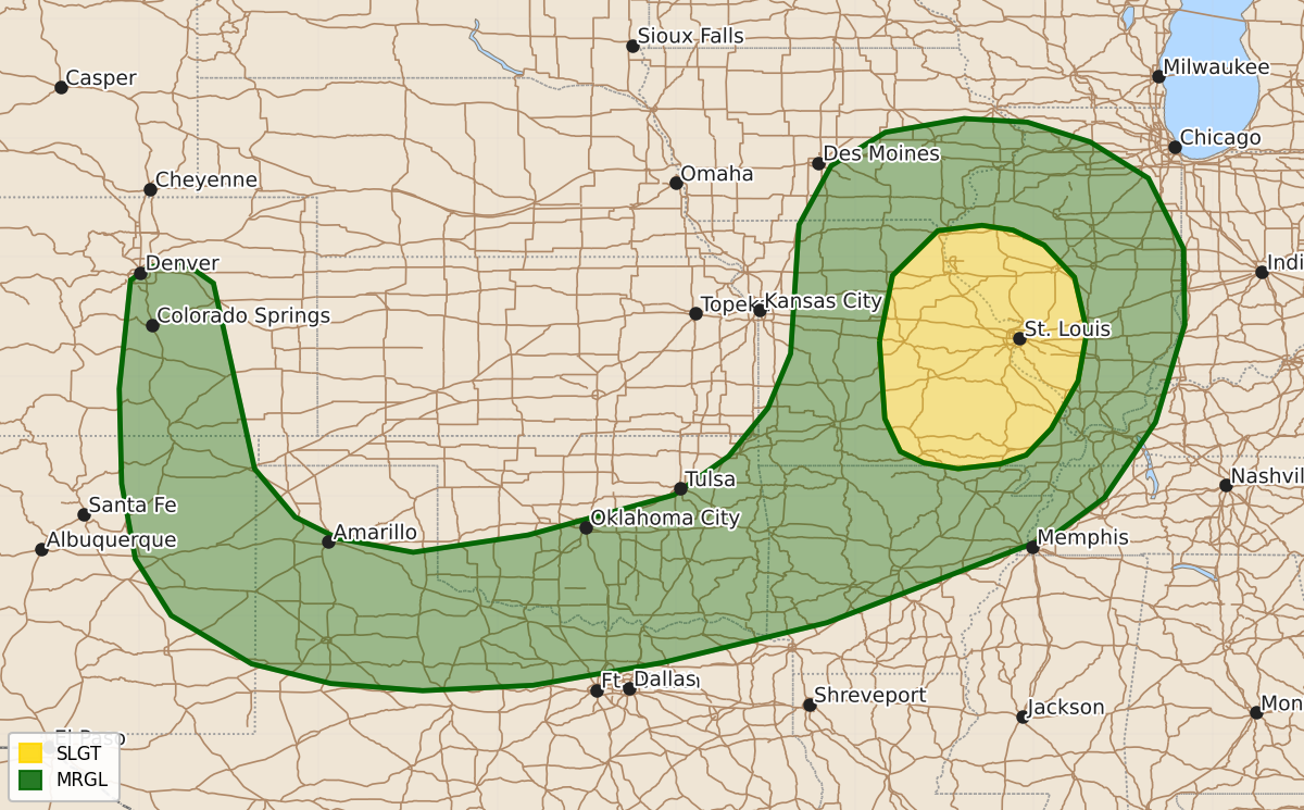
Summary
Severe thunderstorms capable of producing damaging wind gusts and hail are expected this afternoon and evening across parts of the Ozarks and mid Mississippi Valley. Isolated severe wind gusts and hail are also possible this afternoon across the southern Plains and from east-central Colorado into northeastern New Mexico.
Product Text
000 ACUS01 KWNS 310529 SWODY1 SPC AC 310527 Day 1 Convective Outlook NWS Storm Prediction Center Norman OK 1227 AM CDT Fri Jul 31 2026 Valid 311200Z - 011200Z ...THERE IS A SLIGHT RISK OF SEVERE THUNDERSTORMS ACROSS PARTS OF THE OZARKS AND MID MISSISSIPPI VALLEY... ...SUMMARY... Thunderstorms with severe wind gusts and hail will be possible this afternoon and evening across parts of the Ozarks and mid Mississippi Valley. Isolated severe gusts will also be possible in parts of the southern Plains and from east-central Colorado into northeastern New Mexico. ...Ozarks/Mid Mississippi Valley... At mid-levels, a positively tilted shortwave trough will move southeastward across the mid to upper Mississippi Valley. An associated cold front will advance southeastward into the western Ozarks. Ahead of the front, an axis of moisture will be in place with surface dewpoints in the 70s F. As surface temperatures warm, moderate instability will develop along and near the moist axis, with MLCAPE forecast to peak in the 2500 to 3500 J/kg range during the afternoon. In addition to the instability, mid-level flow will be westerly at 30 to 35 knots, which will contribute to moderate deep-layer shear over much of the moist sector. This will result a mixed mode with supercells and organized line segments both possible. Along the instability axis, 0-3 km lapse rates are forecast to peak near 7 C/km which will support a threat for severe wind gusts. The threat could persist into the early to mid evening as storms move southeastward across the mid Mississippi Valley. ...Southern Plains/East-central Colorado/Northeast New Mexico... Northwesterly mid-level flow will be in place across much of the central U.S. today. At the surface, a cold front will move southward into central Oklahoma and the Texas Panhandle by afternoon. An axis of moderate instability will develop ahead of the front as temperatures become hot in the mid to late afternoon. Increasing low-level convergence near the front will result in scattered thunderstorm development. These storms will move south-southeastward across the Red River Valley and southward across the Caprock of west Texas. Very steep low to mid-level lapse rates and large temperature dewpoint spreads exceeding 40 degrees F in some areas will result in a potential for isolated severe wind gusts. Further west into east-central Colorado and northeast New Mexico, an axis of instability will develop by afternoon in and near the foothills of the southern Rockies. Storms will form in the mid to late afternoon in the higher terrain and gradually move southeastward into the lower elevations. Steep low to mid-level lapse rates will support a potential for isolated severe gusts. Hail could also occur with the stronger updrafts. ..Broyles/Chalmers.. 07/31/2026 $$