Day 1 Convective Outlook
This product has been superseded. View the updated product →
Issued: · Valid: –
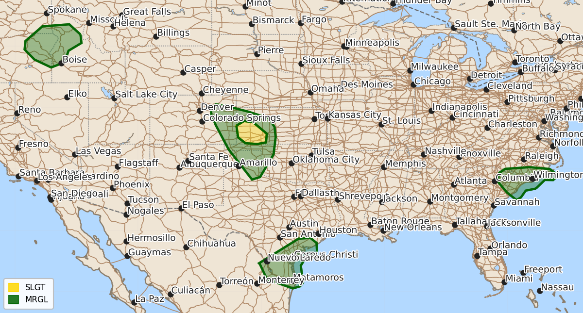
Summary
Scattered severe thunderstorms capable of large hail and damaging wind gusts are expected this afternoon and evening across the central and southern High Plains, including southwest Kansas. Isolated risks for damaging winds and hail also exist for the middle Texas coast through deep South Texas, the eastern Carolinas, and parts of the Columbia Basin and northern Intermountain region.
Product Text
000 ACUS01 KWNS 231620 SWODY1 SPC AC 231618 Day 1 Convective Outlook NWS Storm Prediction Center Norman OK 1118 AM CDT Thu Jul 23 2026 Valid 231630Z - 241200Z ...THERE IS A SLIGHT RISK OF SEVERE THUNDERSTORMS FOR SOUTHWEST KANSAS... ...SUMMARY... Widely scattered severe storms capable of severe wind gusts and large hail are possible over portions of the central and southern High Plains this afternoon and evening. More isolated occurrences of damaging wind are possible from the middle Texas coast into Deep South Texas, the eastern Carolinas, and parts of the Columbia Basin into the northern Intermountain region. ...Central/southern High Plains including western Kansas... Surface analysis late this morning places a front draped from far southwest KS extending into eastern CO. The front and a dryline farther south will focus thunderstorm development later this afternoon as strong heating results in appreciable boundary layer destabilization. Water-vapor imagery shows an impulse over central CO moving slowly east to the north of a mid-level anticyclone centered over northwest TX. This upper disturbance and associated forcing for ascent coupled with weakening convective inhibition will lead to scattered storms developing by late afternoon. Models feature a vertically veering wind profile with 30-35 kt of deep-layer shear over western KS near the front, which will be sufficient for at least episodic supercell structures with a risk for large hail. Some upscale growth into a small cluster may occur during the evening as a southerly LLJ intensifies. Scattered severe gusts will be possible with this activity. Farther west and south along the dryline, a deeply mixed boundary layer and weaker shear will favor an isolated risk for severe gusts with the stronger downdrafts. ...Middle Texas Coast to Deep South Texas... As Bertha continues westward over the northwest Gulf, a belt of enhanced mid-level flow will precede Bertha and spread atop a hot and moist boundary layer inland, with moderate instability developing by afternoon along the middle Texas coast. Ample deep-layer shear within the southwest quadrant of the parent system may support some cold pool organization. Steepened low-level lapse rates and high PW may yield a localized risk for severe gusts with scattered storms that develop near the coast and move inland over the coastal plain through the evening. ...Columbia Basin/northern Intermountain West... Weak height falls are expected while mid/upper-level winds strengthen regionally ahead of an upper low off the coast of the Pacific Northwest. Daytime heating along favored terrain, in conjunction with the glancing influence of the passing disturbance, will aid in isolated to widely scattered thunderstorms by mid-afternoon within a moderately unstable and steep lapse rate environment. The strengthening upper-level winds will enhance vertical shear, supporting the potential for some storm organization with an associated risk for locally damaging wind gusts and marginally severe hail. ...Eastern Carolinas... Midday visible-satellite imagery shows scattered showers/thunderstorms along a west-east oriented frontal zone over southern NC. Cloud breaks south of convective cloud debris will promote additional heating near the coast and moderate destabilization by mid afternoon. A few of the stronger storms that develop this afternoon into the early evening will probably pose a localized risk for damaging gusts. ..Smith/Chalmers.. 07/23/2026 $$