Day 1 Convective Outlook
This product has been superseded. View the updated product →
Issued: · Valid: –
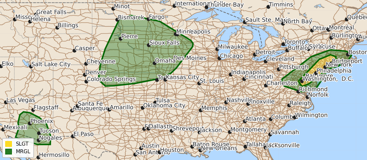
Summary
Scattered strong to severe thunderstorms capable of producing damaging wind gusts and occasional hail are expected across the Mid-Atlantic and southern New England through this evening. Severe storms are also possible across portions of the Northern and Central Plains, as well as Arizona, during the afternoon and evening.
Product Text
000 ACUS01 KWNS 081245 SWODY1 SPC AC 081243 Day 1 Convective Outlook NWS Storm Prediction Center Norman OK 0743 AM CDT Sat Aug 08 2026 Valid 081300Z - 091200Z ...THERE IS A SLIGHT RISK OF SEVERE THUNDERSTORMS FROM NORTHERN PARTS OF THE MID-ATLANTIC INTO SOUTHERN PORTIONS OF THE NORTHEAST... ...SUMMARY... Scattered strong to severe thunderstorms capable primarily of damaging gusts will be possible today across the Mid-Atlantic states into southern New England. ...Mid-Atlantic states into southern New England... Satellite imagery this morning indicates a weak disturbance moving east across the Lower Great Lakes, with early morning showers/thunderstorms from WV/PA into western NY likely associated with this feature. Strong heating from Chesapeake Bay northward into southern portions of the Northeast will yield around 2000 J/kg MLCAPE by early afternoon. Of particular note is seemingly adequate strength of flow between 700-250 mb for organized line segments. Given the relatively high PW environment (1.75-2.0 inches), expecting a few clusters to evolve this afternoon with an attendant risk for strong to locally severe gusts (50-65 mph). Have expanded/increased severe-wind probabilities into southern New England and southward into the Chesapeake Bay vicinity. Marginally severe hail may also occur with the stronger cells before excessive outflow leads to more linear structures as this activity pushes east towards the coast by the early evening. ...Northern/Central Plains into MN/IA/MO... Radar/satellite mosaic shows a cluster of strong to locally severe thunderstorms over the NE Sandhills this morning. This activity may continue southeast this morning but weaken as it moves across central NE. Above average uncertainty/low confidence for this forecast is due in part to weak to negligible forcing features and large model spread on potential evolution of isolated to widely scattered storms later today into tonight. Nonetheless, a strongly unstable airmass is forecast to develop by early afternoon across much of the region with 60s to lower 70s boundary layer dewpoints beneath steep 700-500 mb lapse rates. Several areas of convection may develop during the late afternoon/evening near the surface trough, and overnight near the southward-sagging surface front. Weak convergence along early day outflow may rejuvenate convection or lead to additional isolated storms over southern NE into northern KS. This may also coincide with an increasing low-level jet across the central Plains during the evening into the overnight, but capping will likely limit storm coverage except perhaps near a southward-sagging surface front near the ND/SD border and with warm advection over southern MN into IA. Large hail and severe gusts will be possible with the more intense thunderstorms. Additional high-based convection is possible across eastern CO and western KS/NE. A hot and well mixed boundary layer will probably support isolated severe gusts. ...AZ... Easterly midlevel flow will persist on the southern periphery of an upper high over the Four Corners. Steep midlevel lapse rates and persistent moisture across the region will foster thunderstorm development across the higher terrain during the evening. The hot and well mixed boundary layer will support strong outflow gusts as convection moves westward off higher terrain toward the lower deserts. ..Smith/Kerr.. 08/08/2026 $$