Day 1 Convective Outlook
This product has been superseded. View the updated product →
Issued: · Valid: –
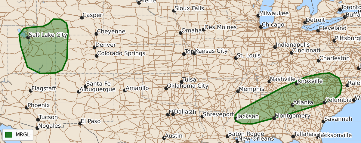
Summary
Isolated severe wind gusts are expected today across much of Utah into southwest Wyoming and western Colorado, while portions of the Southeast may also see strong to locally severe gusts through the early evening.
Product Text
000 ACUS01 KWNS 221224 SWODY1 SPC AC 221222 Day 1 Convective Outlook NWS Storm Prediction Center Norman OK 0722 AM CDT Tue Sep 22 2026 Valid 221300Z - 231200Z ...THERE IS A MARGINAL RISK OF SEVERE THUNDERSTORMS FOR MUCH OF UTAH INTO ADJACENT PARTS OF WYOMING AND COLORADO...AND ACROSS A PORTION OF THE SOUTHEAST... ...SUMMARY... An isolated threat for severe wind gusts is expected today in Utah into southwest Wyoming and western Colorado. Thunderstorms capable of strong to locally severe damaging gusts are also possible across parts of the Southeast. ...Utah into southwest Wyoming and western Colorado... Water-vapor imagery this morning shows a potent mid-level trough over the western Great Basin. This upper feature and an accompanying speed max ---beginning to be sampled by the Cedar City, UT WSR-88D VAD (KICX)--- are forecast to move northeast across UT through early evening. In the wake of early day showers and a few thunderstorms associated with an initial lobe of ascent, some heating will yield steepened 0-2 km lapse rates and the development of marginal buoyancy. As storms develop and intensify, elongated hodographs will support a few stronger cells to be capable of marginally severe hail. However, 60 to 75 mph gusts on an isolated basis will likely be the primary severe hazard. This activity will eventually move into western CO and southwest WY towards the late afternoon/early evening with severe gusts potentially in proximity to stronger cores and outflow. ...Southeast... A slow-moving cold front will aid in focusing thunderstorms across portions of the Deep South into the southern Appalachians. Heating of a moist airmass featuring upper 60s to lower 70s deg F surface dewpoints will likely result in 1500-2500 J/kg MLCAPE by early to mid afternoon. Weak low to mid tropospheric flow will limit overall storm vigor, but some of the stronger water-loaded downdrafts will probably be capable of strong to locally severe gusts and pockets of wind damage into the early evening. ..Smith/Mead.. 09/22/2026 $$