Day 1 Convective Outlook
This product has been superseded. View the updated product →
Issued: · Valid: –
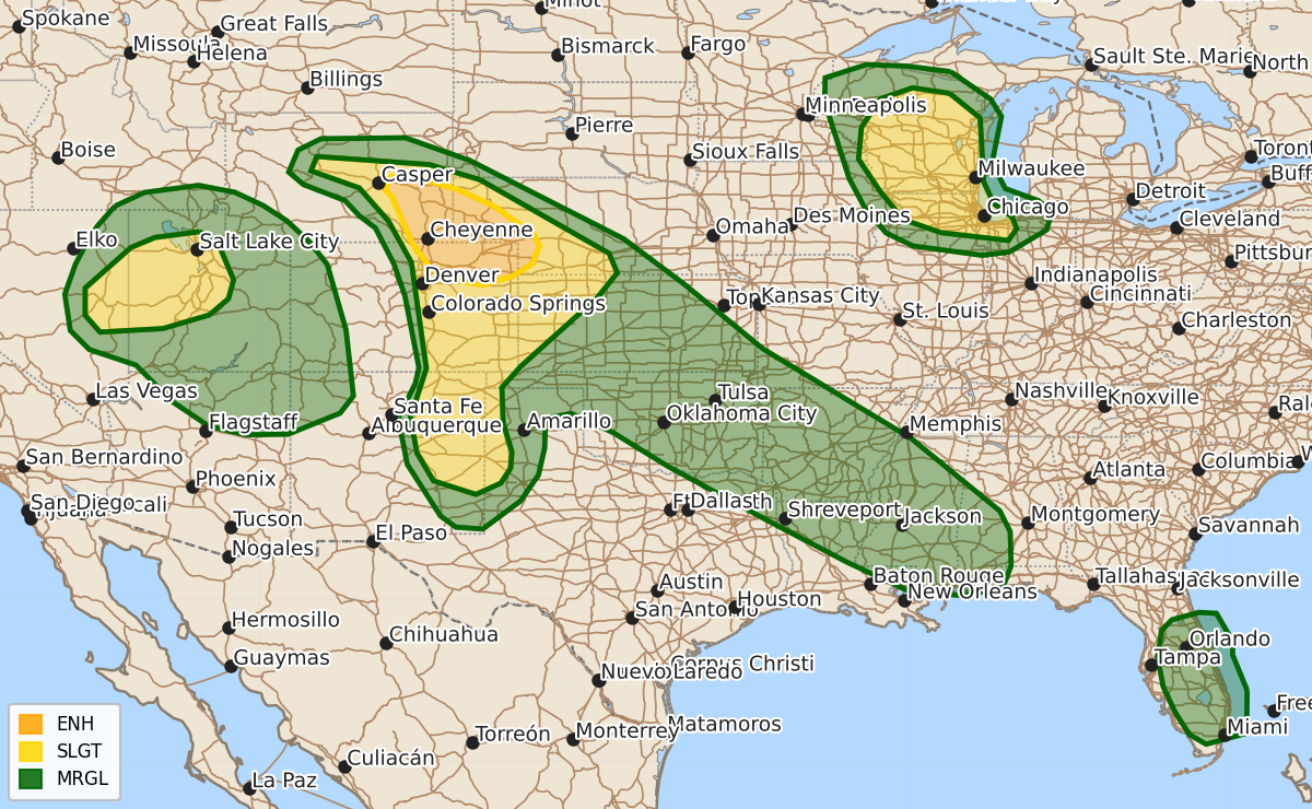
Summary
Scattered severe thunderstorms are expected this afternoon and evening across the central High Plains, the Midwest, and the Great Basin, with a risk of very large hail, damaging wind gusts, and tornadoes. The most intense weather is forecast for the central High Plains, where supercells could produce significant hail and tornadoes, while other areas may experience severe wind gusts and thunderstorms.
Product Text
000 ACUS01 KWNS 242001 SWODY1 SPC AC 241959 Day 1 Convective Outlook NWS Storm Prediction Center Norman OK 0259 PM CDT Wed Jun 24 2026 Valid 242000Z - 251200Z ...THERE IS AN ENHANCED RISK OF SEVERE THUNDERSTORMS ACROSS THE CENTRAL HIGH PLAINS... ...THERE IS A SLIGHT RISK OF SEVERE THUNDERSTORMS ACROSS PARTS OF THE GREAT BASIN...HIGH PLAINS AND MIDWEST... ...SUMMARY... Scattered severe thunderstorms are expected this afternoon and evening across parts of the central High Plains, with a threat for large to very large hail, severe wind gusts, and perhaps a couple of tornadoes. Other severe thunderstorms are expected across parts of the Midwest and Great Basin. ...20Z Update... The forecast remains on track, and only minor adjustments were made with this update. The ENH risk was expanded slightly southeastward in southwestern NE. Here, diurnal heating amid lower 60s dewpoints will yield a corridor of moderate surface-based buoyancy, which combined with 50-60 kt of effective shear, will support the potential for a couple intense supercells capable of producing very large hail and severe gusts. The adjacent SLGT risk was also expanded southeastward into south-central NE and north-central KS, where upscale-growing clusters will pose a risk for severe wind gusts with time. The SLGT risk in eastern NM was expanded westward toward the higher terrain, given the potential for initially discrete supercell structures capable of producing large hail. Finally, a CIG1 wind area was added over portions of the Great Basin, where a deeply mixed boundary layer and increasing buoyancy may support some gusts upwards of 75 mph. ..Weinman.. 06/24/2026 .PREV DISCUSSION... /ISSUED 1149 AM CDT Wed Jun 24 2026/ ...Central/Southern High Plains... Post-frontal low-level moisture will remain over the central High Plains today via low-level upslope flow, which should be most focused/strongest across southeast Wyoming/northeast Colorado, and to a lesser extent, the Raton Mesa vicinity. As daytime heating occurs and low-level clouds present this morning gradually erode, 2000-3000 J/kg of MLCAPE should develop by mid to late afternoon in a narrow corridor across northeast Colorado into southeast Wyoming. This instability will also be aided by the presence of steep mid-level lapse rates. Thunderstorms should develop this afternoon across much the region as strong mid-level west-northwesterly flow associated with a shortwave trough over the northern Plains overspreads the central Rockies/High Plains. Accordingly, the highest convective coverage is anticipated from east-central/southeast Wyoming into northeast/east-central CO, where buoyancy should be maximized. Deep-layer shear will be rather strong, with values up to 50-60 kt. These conditions will support the potential for intense supercells capable of large to very large hail (isolated 2-4 inches in diameter possible). Notable low-level curvature of the hodograph could support a couple of tornadoes in this region as well. Eventual upscale growth into a southeastward-moving MCS capable of producing severe winds is probable into eastern Colorado/western Kansas this evening, with some 75+ mph gusts possible. Lower thunderstorm coverage is anticipated farther south into the southern High Plains, with warmer temperatures and higher cloud bases suggesting a predominantly outflow-dominant mode. Strong to severe gusts will be the primary risk, although isolated hail may also occur. ...Midwest including portions of Wisconsin/northern Illinois... A belt of 40-50 kt westerly mid-level flow will overspread Wisconsin and northern Illinois today as a weak shortwave trough moves across the Upper Midwest and Great Lakes through the period. Seasonably cool temperatures aloft will aid up to around 1000-1500 J/kg of MLCAPE through peak afternoon heating along/ahead of a weak cold front. Current expectations are for scattered to numerous thunderstorms to develop this afternoon with moderate to locally strong deep-layer shear providing support for updraft organization. A mix of multicells and supercells should pose a threat for severe hail and damaging winds, and possibly some tornado risk, as they spread east-southeastward through the afternoon and evening before eventually weakening. ...Great Basin/Four Corners... Current surface observations indicate rather dry conditions across the Great Basin/Four Corners regions this morning. Still, greater low/mid-level moisture is forecast to advect northeastward through the day as a weak mid-level shortwave trough advances east-northeastward from the lower Colorado River Valley across the Great Basin. The boundary layer is expected to become very well mixed with strong daytime heating that will occur this afternoon, with weak instability present. Modestly enhanced mid-level flow will aid in northeastward thunderstorm motions, and some potential exists for strong/gusty outflow winds across a large area this afternoon and early evening. ...Southern Plains into the Lower Mississippi Valley... Thunderstorms should increase/re-intensify regionally this afternoon, aided by multiple MCVs interacting with a convectively augmented front that extends northwest-southeastward regionally. Deep-layer flow and related shear should remain rather modest. Isolated hail and damaging winds may occur with the strongest cores that form, but the potential for more organized clusters is uncertain. Influenced by prior/modifying outflow, at least a conditional-type risk for supercell redevelopment later today is most probable across portions of southern/eastern Oklahoma toward the ArkLaTex. ...Florida... After mostly clear skies this morning, cumulus field continues to increase within a very moist air mass to the south of a front across the northern Florida Peninsula, with low to mid 70s F warm-sector surface dewpoints. While low/mid-level winds will remain weak today, cool mid-level temperatures and ample daytime heating will support the development of moderate to locally strong instability this afternoon. Scattered to numerous pulse-type thunderstorms are expected to develop across the interior Florida Peninsula and Atlantic Coast sea breeze, with occasional damaging winds possible given steepened low-level lapse rates. $$