Day 1 Convective Outlook
This product has been superseded. View the updated product →
Issued: · Valid: –
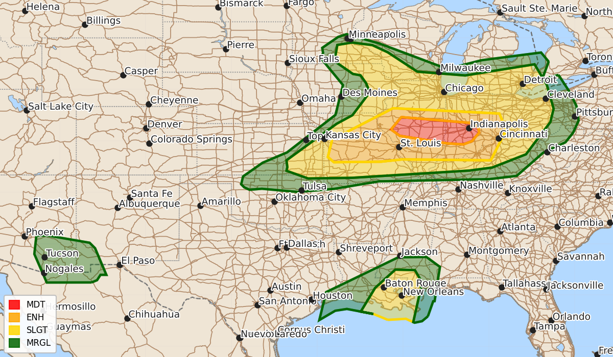
Summary
Severe thunderstorms capable of producing intense tornadoes, large hail, and damaging winds are expected across parts of Illinois and Indiana this afternoon into tonight, with a moderate risk of severe weather. A slight risk of severe thunderstorms and potential tornadoes exists for southeastern Louisiana and southern Mississippi tonight.
Product Text
000 ACUS01 KWNS 172005 SWODY1 SPC AC 172004 Day 1 Convective Outlook NWS Storm Prediction Center Norman OK 0304 PM CDT Wed Jun 17 2026 Valid 172000Z - 181200Z ...THERE IS A MODERATE RISK OF SEVERE THUNDERSTORMS ACROSS PARTS OF ILLINOIS AND INDIANA... ...THERE IS A SLIGHT RISK OF SEVERE THUNDERSTORMS ACROSS PARTS OF SOUTHEASTERN LOUISIANA AND SOUTHERN MISSISSIPPI... ...SUMMARY... Numerous severe thunderstorms remain likely this afternoon into tonight, with the peak threat centered over Illinois and Indiana. Intense tornadoes, swaths of damaging gusts over 75 mph and damaging wind-driven large hail will all be possible. ...20z Update... An extremely complicated forecast scenario will continue this afternoon in the wake of a persistent morning convective cluster. An anomalously strong upper trough and jet are still forecast to move over parts of the Midwest and Great Lakes this afternoon and evening. This will support renewed convective development near the trailing outflow from the morning cluster over the Midwest and along the synoptic cold front from northeast MO into parts of KS and far northern OK. Rapid modification of the air mass along and north of the trailing outflow boundary/effective warm front still appears plausible given 1-2 mb/hr pressure falls, ongoing low-level moisture advection and strong heating ahead of the deepening surface cyclone. A focused mesoscale corridor of strong to intense tornado potential remains evident from east of St Louis, MO, across south-central IL and into west-central IN, where RAP soundings show 1000-2000 J/kg of MLCAPE and exceptionally strong low and mid-level shear with ESRH upwards of 400-600 m2/s2. The primary uncertainty remains the development and maintenance of supercells in the wake of the MCS. CAM guidance remains insistent on a few intense supercells organizing in this corridor from late afternoon into the evening with a risk for strong tornadoes, large hail and damaging winds. The threat may persist into portions of eastern IN, KY and western OH tonight. Across central MO into KS and OK, a very unstable and moderately sheared air mass (18z TOP/SGF RAOBS) will promote rapid supercell development in the next couple of hours along and ahead of the sagging cold front. Large to very large hail, damaging winds and tornadoes are possible. As large-scale forcing for ascent moves away this evening, storm coverage should slowly diminish, though the more intense supercells may linger well into the evening with an all hazards risk. Primary changes to the outlook were to remove northern portions of the ENH and MDT risk areas where substantial air mass recovery is unlikely. Wind probabilities were increased on the southern end near the OH River to account for clustering of expected upstream development. Elsewhere, minor changes were made to trim probabilities behind the cold front. See the previous discussion for additional information. ..Lyons.. 06/17/2026 .PREV DISCUSSION... /ISSUED 1128 AM CDT Wed Jun 17 2026/ ...MO/IL/IN... An intense and fast-moving shortwave trough continues to approach the Midwest today, with an associated 90+ knot mid level jet streaking across the region. A very strong southerly low-level jet precedes this trough, and has resulted in widespread thunderstorms over central IL. The effects of this early convection will be important to the mesoscale details of where the main risk of severe storms will develop later today. The primary outflow boundary from ongoing storms currently extends from extreme northeast MO into south-central IL, and continues to sag southward. Strong heating is occurring to the south of the boundary, and given the intense low-level flow, some northward return is expected. However, it appears unlikely to substantially destabilize as far north as earlier forecasts. The zone in vicinity of the boundary will become very unstable by mid-late afternoon, with forecast soundings continuing to show impressive shear values and hodograph structures suggestive of tornadic supercell potential. Very large hail and damaging winds will also be possible with this activity as it tracks quickly eastward into central IN. Strong tornadoes are possible. By mid-evening, a line of severe storms will likely extend from central MO into southern IN, with damaging winds becoming the primary threat. ...Southeast MN... A small area of heating/destabilization has developed near the surface low over southern MN. Cold temperatures aloft and strong deep-layer shear suggests a threat of a few severe storms capable of hail and gusty/damaging winds this afternoon. ...LA/MS... Tropical Storm Arthur will track northward and affect LA and southern MS tonight. A zone of strong southerly low-level winds to the east of the circulation will result in some concern for overnight and pre-dawn tornadoes across southeast LA into far southern MS. ...Southern AZ/NM... Scattered afternoon and evening thunderstorms are expected across southeast AZ and southwest NM. Strong heating and ample instability will pose a risk of damaging wind gusts in the strongest cells. $$