Day 1 Convective Outlook
This product has been superseded. View the updated product →
Issued: · Valid: –
Summary
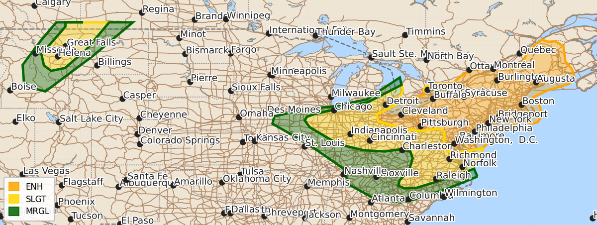
Severe thunderstorms are expected across the lower Great Lakes into the Mid-Atlantic and Northeast this afternoon and evening, bringing damaging wind gusts and a few possible tornadoes. Parts of western Montana may also see severe thunderstorms with damaging gusts and large hail later this afternoon and evening.
Product Text
000 ACUS01 KWNS 181622 SWODY1 SPC AC 181620 Day 1 Convective Outlook NWS Storm Prediction Center Norman OK 1120 AM CDT Sat Jul 18 2026 Valid 181630Z - 191200Z ...THERE IS AN ENHANCED RISK OF SEVERE THUNDERSTORMS THIS AFTERNOON THROUGH LATE EVENING FROM THE LOWER GREAT LAKES INTO THE MID-ATLANTIC... ...THERE IS A SLIGHT RISK OF SEVERE THUNDERSTORMS LATE THIS AFTERNOON EVENING FOR PARTS OF WESTERN MONTANA... ...SUMMARY... Severe thunderstorms are expected across portions of the Ohio Valley and Lower Great Lakes into the Mid-Atlantic and Northeast this afternoon and evening. Damaging gusts will be the primary threat, but a few tornadoes are possible, including perhaps a strong tornado. ...Mid-Atlantic to the lower Great Lakes this afternoon/evening... Ongoing convection across central PA/NY will continue to spread eastward through early afternoon within a warm advection zone along and north of a surface warm front. The warm front will move northward today in advance of a surface cyclone and associated midlevel trough now in the vicinity of Lake Huron. In the wake of the ongoing convection, destabilization will occur as boundary-layer dewpoints rise to near 70 F and surface temperatures into the 80s, resulting in moderate buoyancy in the warm sector. Destabilization will occur earlier immediately south-through-west of the ongoing storms across eastern PA/NJ, and a little later this afternoon into central NY. Additional thunderstorm development is beginning in southwest PA and vicinity as of 16z and a continued increase in storms is expected into early-mid afternoon along a cold front and along pre-frontal confluence zones/lake-enhanced boundaries. A mixed convective mode (line segments and clusters) is expected, with embedded bowing segments and a chance for pre-frontal supercells in PA/NY/NJ where vertical shear and hodograph curvature will be larger along the warm front. Wind damage will be the primary severe threat with both the frontal convection and pre-frontal storms, with a few tornadoes possible with supercell structures and/or embedded mesovortices. ...Northern Rockies late this afternoon/evening... Scattered thunderstorm development is expected later this afternoon/evening across western MT and vicinity, within the northwest fringe of the midlevel ridge and monsoonal moisture plume. Midlevel flow will be somewhat enhanced to the immediate southeast of a midlevel trough moving over southeast BC, thus some organized storm structures will be possible with faster storm motions compared to yesterday. Occasional severe outflow gusts and large hail up to 1.5 inches in diameter will be the main threats. ..Thompson/Bunting.. 07/18/2026 $$