Day 1 Convective Outlook
This product has been superseded. View the updated product →
Issued: · Valid: –
Summary
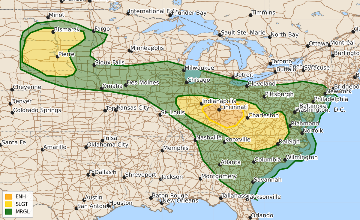
Severe thunderstorms capable of damaging wind gusts, large hail, and brief tornadoes are expected this afternoon and tonight across parts of the Ohio Valley, central Appalachians, and the northern Plains. The most intense wind threats will affect southern Ohio and northern Kentucky, while the northern Plains may see severe storms through the evening.
Product Text
000 ACUS01 KWNS 112001 SWODY1 SPC AC 112000 Day 1 Convective Outlook NWS Storm Prediction Center Norman OK 0300 PM CDT Tue Aug 11 2026 Valid 112000Z - 121200Z ...THERE IS AN ENHANCED RISK OF SEVERE THUNDERSTORMS THIS AFTERNOON INTO EARLY TONIGHT ACROSS PARTS OF THE MIDDLE OHIO VALLEY... ...THERE IS A SLIGHT RISK OF SEVERE THUNDERSTORMS OVER PARTS OF THE NORTHERN PLAINS...AND FROM EASTERN ILLINOIS TO VIRGINIA AND NORTH CAROLINA... ...SUMMARY... Severe thunderstorms with damaging wind gusts will continue today across parts of the Ohio Valley and central Appalachians. Large hail and severe wind gusts are also forecast over parts of the northern Plains. ...20Z Update... The primary change with this update was trimming higher severe probabilities in the wake of earlier convection that moved through parts of eastern IL, northern IN, and northwestern OH. With that said, a risk of severe wind gusts and hail will persist through some of this corridor -- within a relatively narrow zone of moderate-strong surface-based buoyancy along the southern edge of outflow-modified air. Refer to Severe Thunderstorm Watch 565 and MCD 1930 for more information. Farther east, a well-established MCS is tracking southeastward across southern OH toward northern KY. Over the next few hours, these storms will continue to pose the greatest risk for a swath of damaging wind gusts (some upwards of 75 mph) as they track southeastward along a gradient of strong surface-based buoyancy amid 40 kt of deep-layer shear oriented perpendicular to the well-established gust front. Additionally, a modest enhancement to the low-level shear along the buoyancy gradient/baroclinic zone will continue to support brief mesovortex tornadoes in the near-term. See MCD 1931 for more information. Elsewhere, the previous forecast remains on track and only minor changes were made to the outlook. ..Weinman.. 08/11/2026 .PREV DISCUSSION... /ISSUED 1111 AM CDT Tue Aug 11 2026/ ...IL/IN/OH... A fast moving and intense bowing MCS is affecting the Chicago metro area this morning with significant severe wind gusts. This activity will race east-southeastward across northern IN and eventually western OH. Increasingly widespread thunderstorms and associated outflow ahead of this complex lends uncertainty to the evolution of the bow, and the corridor of greatest damaging wind potential. Refer to MDs #1921 and #1922 for further details. ...OH/WV/KY/VA... Another linear MCS is affecting southeast OH, and will spread across WV and into VA later today. The air mass ahead of this complex is not as unstable, and considerable uncertainty exists regarding this system's longevity. Nevertheless, sufficient flow aloft and mesoscale organization will maintain a risk of damaging wind gusts. Refer to MD #1923 for further details. ...ND/SD/NE... Moderately strong westerly flow aloft is present today across the Dakotas, with a moist and unstable air mass in place over the Black Hills region. This will likely lead to widely scattered thunderstorm development by early evening. Supercells capable of large hail and damaging winds are expected. It is unclear how far southeast these storms will maintain intensity, but model guidance suggests at least into central SD before weakening overnight. $$