Day 3 Convective Outlook
This product has been superseded. View the updated product →
Issued: · Valid: –
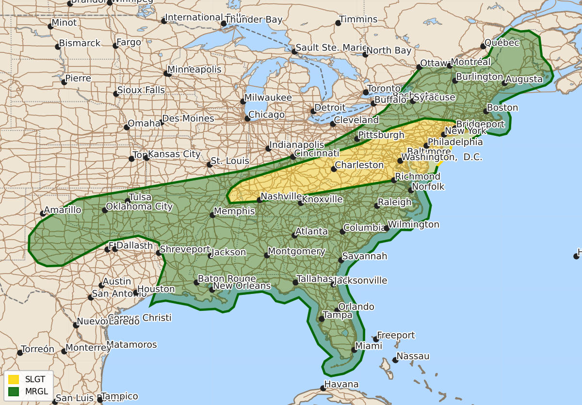
Summary
Isolated to scattered severe thunderstorms capable of producing damaging wind gusts are expected from Kentucky and northern Tennessee through the Mid-Atlantic on Thursday. A marginal risk of severe thunderstorms with damaging winds is also possible across parts of the Southern Plains and Gulf Coast states during the same period.
Product Text
000 ACUS03 KWNS 160727 SWODY3 SPC AC 160726 Day 3 Convective Outlook NWS Storm Prediction Center Norman OK 0226 AM CDT Tue Jun 16 2026 Valid 181200Z - 191200Z ...THERE IS A SLIGHT RISK OF SEVERE THUNDERSTORMS FROM KENTUCKY AND NORTHERN TENNESSEE INTO THE MID-ATLANTIC... ...SUMMARY... Isolated to scattered severe thunderstorms will be possible from Kentucky to the Mid-Atlantic. Damaging wind gusts will be the main hazard with this activity. ...Synopsis... A series of embedded midlevel shortwave troughs will migrate through broad upper troughing and strong southwesterly deep-layer flow from the Great Lakes to the Northeast. At the surface, low pressure over southern Ontario will develop northeast along the St. Lawrence Valley and a trailing cold front will extend southwest from the Lower Great Lakes to northern OK and the TX Panhandle during the morning. This front will sag south/southeast through the period, becoming oriented from the Mid-Atlantic coast to central TX by Friday morning. A very moist airmass will reside south of the front, particularly from the southern Plains to the Mid-Atlantic. Moderate to strong destabilization will develop across parts of the Plains into the Ohio Valley, with more modest instability with northeast extent into the Mid-Atlantic and Northeast. ...Ohio Valley to Mid-Atlantic and Northeast... Very strong west/southwesterly mid/upper flow is expected to reside across the Northeast on Thursday, decreasing with southwest extent into the Ohio Valley. Convection may be ongoing near the surface front and within the broad warm advection regime ahead of the boundary Thursday morning, especially across the Northeast. This will likely temper destabilization across portions of PA/NY and points northeastward. Nevertheless, intense deep-layer flow will still support strong to severe wind gusts with convection through early evening. Richer boundary layer moisture will be in place from TN/KY into the Mid-Atlantic, fostering strong destabilization. Clusters and line segments will pose a risk for mainly damaging gusts. ...OK/TX to the Mid-South... A belt of strong instability is forecast ahead of the southward sagging cold front Thursday afternoon. This area will be further removed from stronger mid/upper southwesterly flow. But, ample instability, modest effective shear, and high PWs supporting water laden downdrafts will result in a marginal severe risk for damaging winds within thunderstorm clusters/bands. ...Southeast... The remnants of a tropical disturbance is expected to migrate across portions of the Gulf Coast states on Thursday. A very moist and moderately unstable airmass will be in place. The remnant low may serve to locally enhance vertical shear, resulting in an accompanying risk for strong wind gusts and perhaps a tornado or two. ..Leitman.. 06/16/2026 $$