Day 1 Convective Outlook
This product has been superseded. View the updated product →
Issued: · Valid: –
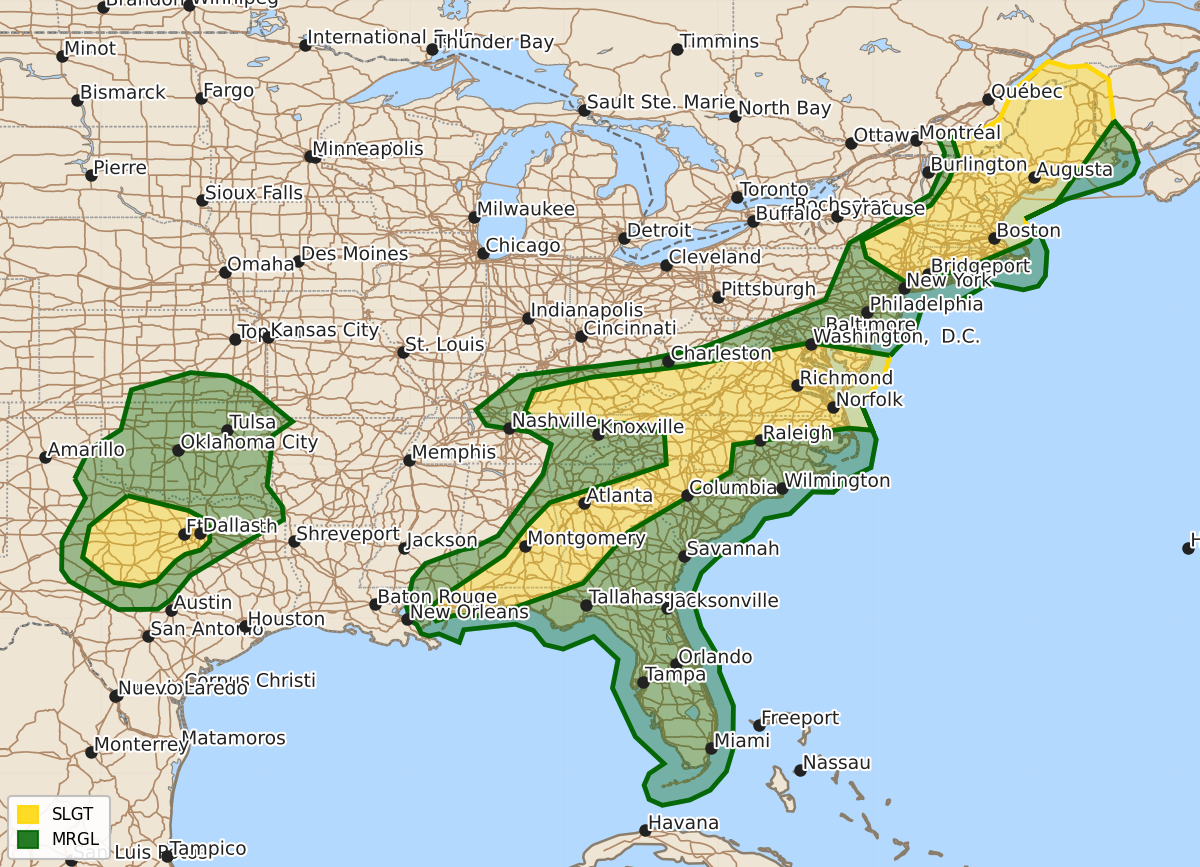
Summary
Severe thunderstorms capable of producing damaging winds, hail, or tornadoes are expected across western North Texas, the Southeast, the Mid-Atlantic, and New England through tonight. Risks include damaging wind gusts and hail in the Plains and Mid-Atlantic, with potential tornadoes and wind threats persisting through the evening in the Southeast and New England.
Product Text
000 ACUS01 KWNS 181959 SWODY1 SPC AC 181958 Day 1 Convective Outlook NWS Storm Prediction Center Norman OK 0258 PM CDT Thu Jun 18 2026 Valid 182000Z - 191200Z ...THERE IS A SLIGHT RISK OF SEVERE THUNDERSTORMS OVER PORTIONS OF WESTERN NORTH TEXAS...THE SOUTHEAST AND CAROLINAS...INTO NEW ENGLAND... ...SUMMARY... Isolated to scattered severe thunderstorms remain likely from Kentucky and the central Appalachians to the Mid-Atlantic, with primarily damaging wind gusts or marginal hail. Scattered severe storms are possible from upstate New York into New England, with damaging wind gusts and tornado potential. A few tornadoes may also occur over parts of the middle Gulf Coast and southeast states, and scattered storms may produce damaging winds or marginal hail from Oklahoma into western North Texas. ...20z Update TX/OK... Forecast confidence has increased late this afternoon into tonight that one or more semi-organized clusters of thunderstorms will develop and spread southeastward across parts of western North TX with a risk for damaging gusts. Strong convergence near an anomalously deep surface low and sagging cold front will support numerous thunderstorms tonight. Despite marginal deep-layer shear for organization, a hot and very unstable air mass in vicinity of the surface low will allow for strong cold pool development, potentially supporting severe outflow gusts. More isolated damaging gusts and/or marginally severe hail remain possible farther north into OK. Have upgraded wind probabilities to 15% and a categorical Level 2 Slight Risk for portions of western North TX. ...Southeast... Convection associated with the remnants of Arthur will persist through tonight along a stalled frontal zone in the Southeast. While clustering has resulted in more linear structures, enhanced flow aloft and pockets of stronger low-level shear near the front may still support occasional rotating updrafts, with the risk for a couple of tornadoes or damaging gusts from eastern AL, into GA and the western Carolinas through tonight. Have reduced maximum tornado probabilities, but will maintain a broad 5% for occasional supercell structures along/near the front. ...New England... The broken band of storms ahead of the cold front should continue eastward and gradually weaken into this evening. Southern portions of the line over MA, CT and RI may remain stronger given better buoyancy, but storm coverage here should become more isolated with time. Damaging gusts and perhaps a tornado or two remain possible. Have trimmed probabilities behind the cold front where the risk has decreased. No other changes were made, see the previous discussion for more information. ..Lyons.. 06/18/2026 .PREV DISCUSSION... /ISSUED 1116 AM CDT Thu Jun 18 2026/ ...NY/New England... A fast-moving low-topped squall line is tracking eastward across NY. Low and mid level wind fields in this region are very strong, contributing to occasional bowing structures and QLCS mesocyclones. This activity will spread into VT/NH through the afternoon with a continued risk of damaging winds and isolated tornadoes. Confidence in severe storms farther south into southern New England is lower, but at least isolated strong/damaging wind gusts are possible. ...KY into Mid Atlantic... A remnant outflow boundary from overnight storms extends across KY into southern VA. Strong heating along and south of the boundary will likely result in renewed convection this afternoon, in a zone of moderate westerly flow aloft and CAPE values around 2000 J/kg. A few severe storms are expected in this corridor, with activity moving into northern NC later today. Damaging winds are the main risk. ...Gulf Coast into Carolinas... The remnant circulation of Arthur is becoming more progressive with time, and is accelerating eastward. As this occurs, the zone of relatively strong southerly low-level winds will also shift across AL into GA and eventually SC/NC tonight. Ample low-level moisture and high theta-e values will coincide with the region of strong shear, and CAM solutions suggest clusters of thunderstorms in this area as well. This suggests at least some risk of damaging wind gusts and tornadoes through the afternoon and night as the system moves northeastward. ...TX/OK... Scattered thunderstorms will occasional hail risk will slowly diminish across northern OK this afternoon. Later today, new thunderstorms are expected to develop in a hot and very unstable air mass in vicinity of the surface low near ABI/SJT. These slow-moving storms will have some damaging wind and hail risk through the evening. $$