Day 3 Convective Outlook
This product has been superseded. View the updated product →
Issued: · Valid: –
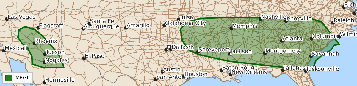
Summary
Scattered strong-to-severe thunderstorms capable of producing damaging winds are possible across much of the Southeast on Sunday. Additional strong-to-severe thunderstorms are also expected across portions of Arizona late Sunday into Sunday night.
Product Text
000 ACUS03 KWNS 100730 SWODY3 SPC AC 100729 Day 3 Convective Outlook NWS Storm Prediction Center Norman OK 0229 AM CDT Fri Jul 10 2026 Valid 121200Z - 131200Z ...THERE IS A MARGINAL RISK OF SEVERE THUNDERSTORMS ACROSS MUCH OF THE SOUTHEAST AND PORTIONS OF ARIZONA... ...SUMMARY... Scattered strong-to-severe thunderstorms capable of producing wind damage will be possible across much of the Southeast on Sunday. Additional strong-to-severe thunderstorms will be possible across portions of Arizona late Sunday into Sunday night. ... Synopsis ... The western ridge will continue to build northward on Sunday, with the highest 500-mb heights (nearing 600 dam) becoming centered over the Dakotas. To the south and east of this substantial ridge, ensemble guidance has a highly-positively tilted trough, with perhaps an embedded closed low, across the Tennessee and Lower Mississippi Valleys. At the surface, a weak boundary will stretch from west-to-east from the Southern Plains into the Southeast. The exact location of this boundary will be highly influenced by repeated rounds of convection the prior two days. ... Southeast ... A very moist airmass will remain in place across the region with surface dewpoint temperatures in the 60Fs and 70Fs and precipitable water values around 2 inches likely to the south of the surface boundary. As diurnal heating occurs, scattered thunderstorms should once again develop along the residual surface boundary. Despite the proximity of a closed low/positively tilted trough, vertical wind shear will be generally less than 20 knots. The result will be scattered single cell and clusters of multicell thunderstorms capable of producing strong to perhaps damaging downbursts. ... Arizona ... Modest easterly mid-level flow will persist across Arizona on Sunday as the region remains south of the closed mid-level high over the northern US. At the surface, southerly to westerly winds will combine with this mid-level flow to support around 30 knots of deep-layer shear. Model guidance shows a seasonably moist airmass in place across much of southern and western Arizona, with surface dewpoints rising into the upper-50Fs to mid-60Fs. The warm, moist environment in place will support afternoon thunderstorm development across the favored higher terrain of the Mogollon Rim. The deep-layer flow should support at least a few of these storms moving west, off the terrain. Steep low-level lapse rates will support strong downward momentum transport capable of producing damaging wind gusts with any thunderstorm. ..Marsh.. 07/10/2026 $$