Day 2 Convective Outlook
This product has been superseded. View the updated product →
Issued: · Valid: –
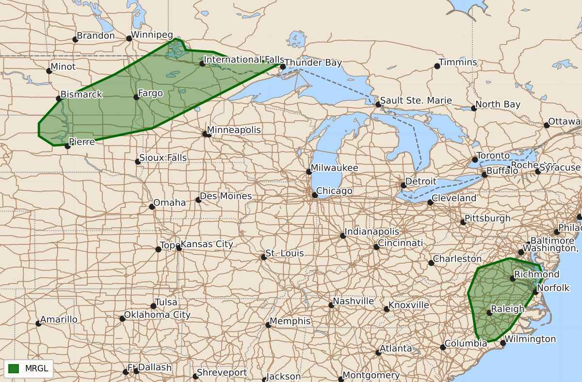
Summary
Marginal severe thunderstorms are possible across parts of the central and eastern Dakotas, northern Minnesota, and the Mid-Atlantic on Monday afternoon and evening. These storms could produce severe hail and damaging wind gusts.
Product Text
000 ACUS02 KWNS 050445 SWODY2 SPC AC 050443 Day 2 Convective Outlook NWS Storm Prediction Center Norman OK 1143 PM CDT Sat Jul 04 2026 Valid 061200Z - 071200Z ...THERE IS A MARGINAL RISK OF SEVERE THUNDERSTORMS MONDAY INTO MONDAY EVENING ACROSS PARTS OF THE CENTRAL AND EASTERN DAKOTAS THROUGH NORTHERN MINNESOTA AND ACROSS PARTS OF THE MID ATLANTIC... ...SUMMARY... Strong thunderstorm development posing at least some risk for severe weather is possible across parts of northern Minnesota through the eastern and central Dakotas, as well as across parts of the Mid Atlantic, Monday afternoon into evening. ...Discussion... Downstream of digging large-scale mid-level troughing and an associated surface cyclone slowly approaching the British Columbia and Pacific Northwest coast, ridging may become increasingly prominent across Baja California through the southern Rockies and central Great Plains during this period. Mid-level heights may tend to remain steady or slowly rise as far north as the eastern Montana/North Dakota international border, in the wake of a notable mid-level trough forecast to progress through northwestern Ontario and Hudson Bay by late Monday night. It appears that one vigorous impulse embedded within the troughing, and forecast to continue accelerating east-northeastward, to the north of the international border, may provide support for stronger secondary surface cyclogenesis across the southern Hudson Bay vicinity by Monday night. To the east of the mid-level ridging, weak mid-level troughing may continue to drift slowly east of the Mississippi Valley, toward the Appalachians. In association with this evolving regime, the potential for organized severe thunderstorm activity still appears generally low and dependent on sub-synoptic developments with rather low predictability at this time frame. This continues to be reflected in latest model output, including convection allowing and related guidance, which exhibit sizable spread concerning potential convective evolution and locations with higher probabilities for thunderstorm development. ...Northern Great Plains... Deeper surface troughing and mid-level height falls are forecast to pass to the north of the international border through this period. However, there appears at least some continuing signal in model output that boundary-layer moisture return to the vicinity of weak pre-frontal surface troughing, coincident with southeastward suppression of warmer and more strongly capping elevated mixed-layer air, could allow for scattered strong thunderstorm development by late Monday afternoon. If this occurs, moderate to large potential instability, in the presence of at least modest shear beneath 30-40 kt 500 mb flow, probably will be conducive to storms capable of producing severe hail and wind, before perhaps tending to be undercut by a southward advancing cold front trailing the developing Canadian cyclone. ...Mid Atlantic... The timing and/or location of highest thunderstorm probabilities across the region differs notably between the REFS and HREF calibrated thunderstorm guidance, and deep-layer mean flow and shear will be rather weak. However, destabilization within broad, weak surface troughing to the lee of the Blue Ridge might become sufficient to focus scattered thunderstorm development with potential to produce localized damaging surface gusts Monday afternoon into early evening. ..Kerr.. 07/05/2026 $$