Day 2 Convective Outlook
This product has been superseded. View the updated product →
Issued: · Valid: –
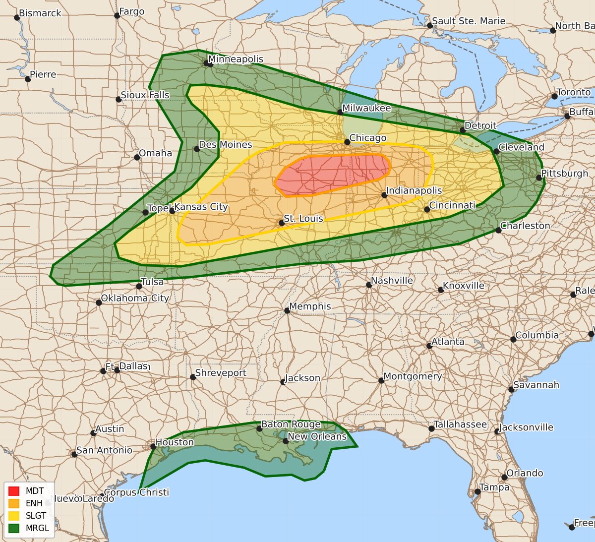
Summary
Severe thunderstorms capable of producing intense tornadoes, 80 mph wind gusts, and large hail are expected across portions of Illinois and Indiana on Wednesday.
Product Text
000 ACUS02 KWNS 160600 SWODY2 SPC AC 160559 Day 2 Convective Outlook NWS Storm Prediction Center Norman OK 1259 AM CDT Tue Jun 16 2026 Valid 171200Z - 181200Z ...THERE IS A MODERATE RISK OF SEVERE THUNDERSTORMS ACROSS PORTIONS OF CENTRAL ILLINOIS INTO NORTHWEST INDIANA... ...SUMMARY... An outbreak of severe thunderstorms is expected across portions of Illinois and Indiana on Wednesday. Intense tornadoes, swaths of damaging gusts to 80 mph and hail to 2.5 inch diameter are expected. ...Midwest... A volatile environment for severe thunderstorms is expected to develop across portions of the Midwest from IA/MO into IL/IN/OH on Wednesday, with significant all-hazards severe expected. A mid/upper level shortwave trough initially over the northern Plains early Wednesday will pivot southeast across the Upper Midwest through 00z, and much of the Great Lakes by 12z Thursday. As this occurs, particularly intense mid and upper level flow, especially by June standards, if forecast to increase over the region. A 60-80 kt westerly 500 mb jet stream will overspread much of the Midwest through the evening, before increasing further during the nighttime hours. Furthermore, an impressive southwesterly 850 mb low-level jet around 50-60 kt will be oriented from KS into IA at 12z. This feature will spread east/northeast across IL/IN/OH through evening. Interestingly, the core of the low-level jet may be somewhat displaced to the east of the core warm sector expected to develop across the Mid-MS Valley vicinity, perhaps tied to an early-day shortwave impulse ejecting across IA/IL during the morning. Nevertheless, 40-55 kt 850 mb winds will persist even across the warm sector even as the core of the low-level jet overspreads the Ohio Valley toward Lower MI during the afternoon. At the surface, an elongated area of low pressure will extend from ND to the Mid-MO valley Wednesday morning. A warm front will extend from northwest IA southeastward across central IL, while a cold front extend from eastern NE into western KS. As this system progresses east through the day, the warm front will lift northward into northern IL/IN/OH and upper 60s/near 70 dewpoints are expected. Aided by steep midlevel lapse rates/cooling aloft, MLCAPE will approach 2500-3500 J/kg. The latitude of the warm front continues to be a point of uncertainty. Most forecast guidance depicts morning convection near and north of the warm front within a strong warm advection regime moving eastward across IA/northern IL/IN. It is uncertain if this will suppress the northward advancement of the warm front. The ultimate position of the warm front will have large impacts on where particularly concerning strong to intense tornado potential may eventually develop as storm motion would likely be along the boundary, rather than across the boundary, allowing for potentially fast-moving/long-track supercells interacting with the warm front and remaining within the favorable warm sector. As the surface cold front develops east, additional convection will develop along the boundary by late afternoon/early evening from far southeast IA into northern MO and eastern KS. Initial supercells along this boundary will pose an all hazards risk -- including very large hail, strong tornadoes and damaging gusts. With time, this convection may develop into a line propagating east/southeast. If a linear MCS develops, swaths of damaging wind gusts will be possible. In general, given the strength of background flow fields, damaging wind potential could be significant regardless of storm mode. Furthermore, even storms developing north of the warm front could still produce severe gusts given large MUCAPE, fast storm motion and intense flow just above the surface. Favorable low-level shear will also support continued tornado potential even within a linear storm mode via embedded supercell structures and mesovortex generation. Large to very large hail potential is most likely early in storm development and where supercells are more likely to remain discrete (northern MO/far southeast IA/north-central IL). ...Gulf Coast... Isolated strong gusts are possible in association with a tropical disturbance moving eastward along the Gulf Coast. See the tropical weather outlook from the National Hurricane Center for more information. ..Leitman.. 06/16/2026 $$