Day 1 Convective Outlook
This product has been superseded. View the updated product →
Issued: · Valid: –
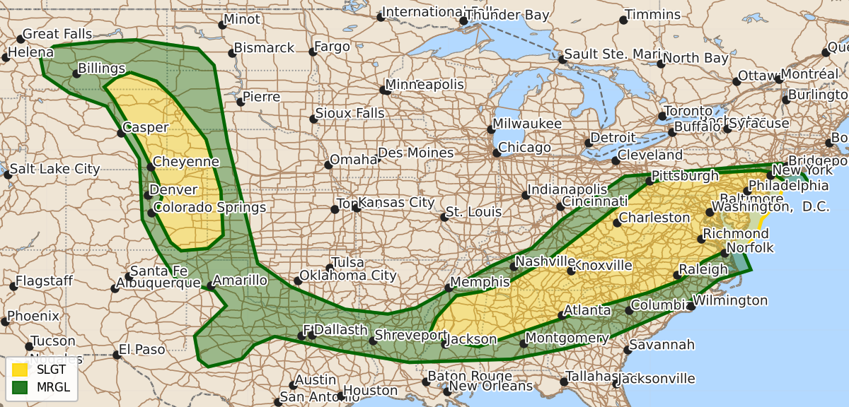
Summary
Scattered severe thunderstorms capable of producing large hail, damaging winds, and isolated tornadoes are expected this afternoon and evening across the central High Plains and from the Southeast through the Mid-Atlantic. Severe storms in the High Plains may bring particularly large hail, while the Mid-Atlantic and Southeast face risks of damaging winds and occasional tornadoes.
Product Text
000 ACUS01 KWNS 221958 SWODY1 SPC AC 221957 Day 1 Convective Outlook NWS Storm Prediction Center Norman OK 0257 PM CDT Mon Jun 22 2026 Valid 222000Z - 231200Z ...THERE IS A SLIGHT RISK OF SEVERE THUNDERSTORMS ACROSS THE CENTRAL HIGH PLAINS AND FROM THE SOUTHEAST TO THE MID ATLANTIC COAST... ...SUMMARY... Scattered severe thunderstorms capable of producing damaging winds and perhaps a couple of tornadoes should occur this afternoon and evening across portions of the Mid-Atlantic into the Southeast. Scattered severe thunderstorms are also expected across the northern/central High Plains, with large to very large hail and a tornado or two. ...20z Update Central High Plains... Minimal changes were made to the prior outlook. Strong to severe storms, including supercells, are developing across parts of WY and CO and should spread east/southeastward this afternoon and evening. Steep mid-level lapse rates and the discrete mode should favor significant severe hail with these storms into this evening. A tornado or two is also possible, focused mostly along the Cheyenne Ridge where stronger low-level shear is being observed. ...Mid Atlantic... Several rounds of storms remain likely this afternoon and evening beneath the strong mid-level zonal flow aloft. Damaging winds appear to be the most likely threat with scattered but mostly cellular storms through this evening. A tornado or two remains possible. This is most likely near the warm front across northern NJ and southern Long Island where stronger and backed low-level flow is supporting 100-150 0-1km SRH. Some guidance shows an increase in storm clustering and stronger outflow gusts from northern VA into northern MD/DE and southern PA/NJ this evening. Should this occur, a locally more favorable corridor of damaging winds could develop. However, this remains very uncertain given the more scattered and cellular convection observed so far. ...TX/OK... Some mode signal exists for isolated convective development this afternoon along the trailing outflow boundary across north TX from the morning MCS. Very large buoyancy and steep mid-level lapse rates could support hail with these storms. However, the lack of broader large-scale ascent suggests more isolated coverage through this evening. ..Lyons.. 06/22/2026 .PREV DISCUSSION... /ISSUED 1120 AM CDT Mon Jun 22 2026/ ...Mid Atlantic... Relatively fast zonal flow is present today from the OH Valley into the Mid-Atlantic and Northeast US, with a shortwave trough evident over OH/MI. As this feature tracks eastward, it will push a surface cold front southward across the central Appalachians and into the Mid-Atlantic region. Considerable clouds are present ahead of the front from KY/WV into VA/PA/NJ, limiting destabilization and confidence in the details of where clusters of storms may form later today. However, given the relatively strong winds aloft and dewpoints in the 60s, it would seem likely that scattered strong to severe storms will occur, capable of locally damaging winds and perhaps a tornado. ...TN/MS/AL/GA... The remnants of a severe overnight MCS are over AR/west TN/northern MS. This system has considerable mesoscale organization with an MCV noted over eastern AR. A very moist and unstable air mass is in place ahead of this system over northern MS/AL, where heating into the mid 80s will foster thunderstorm intensification this afternoon. Damaging winds are the main concern with these storms, but a low-level jet feature associated with the MCV could result in a few supercell structures and the risk of a tornado or two. Activity will track into north GA this evening. Refer to MD #1252 for further details. ...Central High Plains... Similar to yesterday, low-clouds are slowly burning off across the High Plains of eastern CO and western SD/NE/KS, where moderate CAPE values will develop by mid-afternoon. Easterly/upslope flow will contribute to scattered thunderstorm development over eastern WY and southward along the DCVZ in CO. These storms will track into the CAPE axis, where favorable deep-layer shear will promote supercells capable of very large hail and a few tornadoes. $$