Day 1 Convective Outlook
This product has been superseded. View the updated product →
Issued: · Valid: –
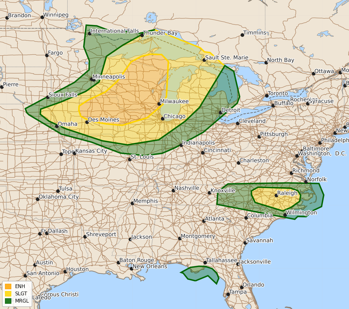
Summary
Severe thunderstorms capable of producing tornadoes, large hail, and damaging winds are expected across parts of the Upper Midwest and Great Lakes from this afternoon through tonight, with an enhanced risk for eastern Iowa, northwestern Illinois, Wisconsin, and western Upper Michigan. Additionally, central North Carolina may see damaging wind gusts this afternoon, and isolated tornadoes or waterspouts are possible today near the Florida Big Bend.
Product Text
000 ACUS01 KWNS 201632 SWODY1 SPC AC 201630 Day 1 Convective Outlook NWS Storm Prediction Center Norman OK 1130 AM CDT Mon Jul 20 2026 Valid 201630Z - 211200Z ...THERE IS AN ENHANCED RISK OF SEVERE THUNDERSTORMS THIS AFTERNOON INTO EARLY TONIGHT FROM EASTERN IOWA AND NORTHWESTERN ILLINOIS ACROSS WISCONSIN INTO WESTERN UPPER MICHIGAN... ...THERE IS A SLIGHT RISK OF SEVERE THUNDERSTORMS THIS AFTERNOON ACROSS CENTRAL NORTH CAROLINA... ...SUMMARY... Severe thunderstorms are expected across portions of the Upper Midwest and Great Lakes vicinity, especially late this afternoon into late evening. A few strong-intense tornadoes, swaths of damaging winds, and isolated very large hail will all be possible. Isolated damaging gusts may also occur over parts North Carolina this afternoon. ...Upper Midwest through tonight... A midlevel shortwave trough is cresting the ridge and will turn southeastward today while moving over the upper MS Valley, as an associated cold front likewise moves southeastward into Upper MI, WI and IA. Earlier storms in Upper MI have weakened, while a cluster is ongoing in eastern IA. Destabilization will occur in the wake of the eastern IA storms as a reservoir of low-mid 70s boundary-layer dewpoints spreads northeastward from IA/southern MN into WI and western Upper MI. The low-level moistening will occur beneath a plume of midlevel lapse rates greater than 8 C/km and in tandem with surface heating in cloud breaks, all of which will drive MLCAPE in excess of 3000 J/kg. As is typical with lingering morning convection, there is some uncertainty regarding the specific locations of afternoon storm development in its wake. Wind profiles will favor supercells as the initial storm mode this afternoon along and just ahead of the cold front, given very long hodographs oriented largely orthogonal to the front. Low-level shear/hodograph curvature will also be substantial, which combined with the moist boundary layer, steep lapse rates and large buoyancy will support the potential for a few strong-intense tornadoes. Very large hail will be possible with the more discrete supercells, while significant severe outflow gusts will be possible with any clustering of storms later this afternoon/evening. Initial supercells will likely evolve into a cluster or two by early tonight while spreading southeastward across eastern IA, northern IL, northwest IN and Lower MI with a continued threat for occasional wind damage and isolated large hail. ...Central NC area this afternoon/evening... Thunderstorm development is expected again this afternoon along a stalled front/differential heating zone across NC, to the west of the more persistent cloud cover in far eastern NC. NC remains near the south edge of the midlevel westerlies, with mid 70s boundary-layer dewpoints coincident with temperatures at or above 90 F contributing to MLCAPE in excess of 2000 J/kg. A few damaging downbursts will be possible with precipitation-loaded downdrafts in an environment with steepening low-level lapse rates. ...FL Big Bend today... Tropical Depression #2 is forecast to drift slowly westward across the northeast Gulf through tomorrow and become a tropical storm. Though deep-layer wind profiles are not particularly favorable in the northeast quadrant of the cyclone, where winds aloft are from the northeast, there is just enough low-level shear to support weakly rotating storms in the outer convective bands. An isolated tornado/waterspout or two may occur today in coastal areas of the FL Big Bend. ..Thompson/Chalmers.. 07/20/2026 $$