Day 3 Convective Outlook
This product has been superseded. View the updated product →
Issued: · Valid: –
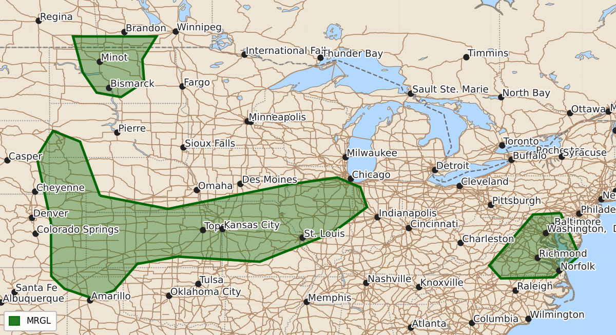
Summary
Scattered strong thunderstorms are expected across parts of the central Great Plains through the middle Mississippi Valley and portions of the Mid-Atlantic from Thursday through Thursday night. Isolated strong storms may also impact parts of central North Dakota late Thursday afternoon into the evening.
Product Text
000 ACUS03 KWNS 070734 SWODY3 SPC AC 070733 Day 3 Convective Outlook NWS Storm Prediction Center Norman OK 0233 AM CDT Tue Jul 07 2026 Valid 091200Z - 101200Z ...THERE IS A MARGINAL RISK OF SEVERE THUNDERSTORMS THURSDAY INTO THURSDAY NIGHT ACROSS PARTS OF THE CENTRAL GREAT PLAINS THROUGH MIDDLE MISSISSIPPI VALLEY...PARTS OF THE NORTHERN GREAT PLAINS AND PARTS OF THE MID ATLANTIC... ...SUMMARY... Scattered strong thunderstorm development, potentially including a few evolving clusters, may impact portions of the central Great Plains through middle Mississippi Valley and parts of the Mid Atlantic Thursday through Thursday night. Much more isolated strong storms may impact parts of central North Dakota late Thursday afternoon into evening. ...Discussion... Modest mid-latitude westerlies are forecast to remain centered near the Canadian/U.S border through this period. In the wake of one short wave trough slowly continuing to pivot northward into the Northwest Territories, and ahead of another digging near the British Columbia coast, broad mid-level ridging is forecast to build along the central Canadian/U.S. border Thursday through Thursday night. Downstream, to the south of a perturbation digging southeast of the Hudson/James Bays, broad mid-level troughing is forecast to overspread the lower Great Lakes through northern Atlantic Seaboard. In lower latitudes, models suggest that a number of more subtle perturbations, a couple of which may generated or strengthened by convection, will progress through otherwise weak, zonal flow around the northern periphery of mid-level ridging centered in the subtropics. It appears that the most substantive thunderstorm development through this period will focus along this corridor, roughly east of the Front Range and Sangre de Cristo Mountains into portions of the middle Mississippi Valley, and across portions of the Mid Atlantic. ...Front Range through middle Mississippi Valley... The 07/00Z NAM is most prominent in generating a notable MCV by 12Z Thursday, associated with thunderstorm development across the central Great Plains Wednesday night. And it substantively intensifies this feature as it migrates across the lower Missouri/middle Mississippi Valleys Thursday through Thursday night. This includes a strengthening jet to 50-70 kt around 700 mb, suggesting the existence of intensifying organized convective system with the potential to produce swaths of damaging surface gusts. This is much stronger than what is generated by the ECMWF, with the GFS indicating a perturbation between these extremes. Given the potential for a moist boundary layer with seasonably high moisture content, including lower/mid 70s F, it does appear that there may be sufficient CAPE to support the evolution of a significant severe convective system. However, the predictability of this type of feature in this type of regime at this extended range is relatively low, and reflected in the guidance. At this point severe probabilities will be introduced at 5 percent, but this will change if the consensus of guidance trends in the current direction of the NAM. Otherwise, destabilization to the lee of the Front Range and Sangre de Cristo Mountains will probably depend on the extent of stabilizing outflow left across the central Great Plains at the outset of the period. However, at least the eastern slopes into adjacent high plans may become a focus for scattered strong thunderstorm development posing a risk for severe hail and wind by late afternoon. A remnant baroclinic zone associated with the convective outflow across Missouri into Kansas may provide another focus for strong to severe thunderstorm development late Thursday evening into Thursday night, near the nose of a nocturnally strengthening low-level jet. ...Mid Atlantic... Destabilization to the lee of the Blue Ridge Mountains (centered across Virginia Thursday) may again become sufficient to support convection with potential to produce strong wind gusts and grow upscale, aided by forcing for ascent associated with a remnant short wave impulse emerging from the Tennessee Valley. ..Kerr.. 07/07/2026 $$