Day 1 Convective Outlook
This product has been superseded. View the updated product →
Issued: · Valid: –
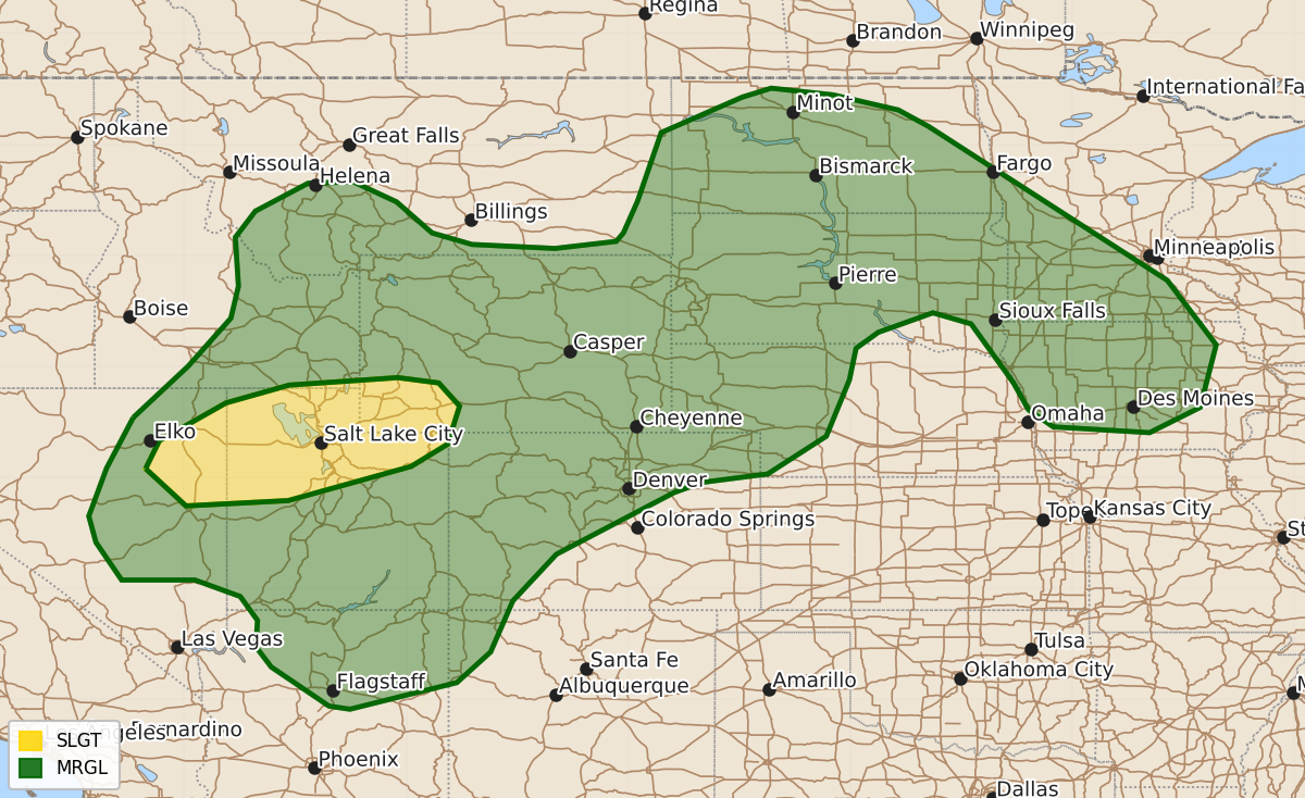
Summary
Severe thunderstorms capable of producing damaging wind gusts and hail are expected throughout parts of eastern Nevada, northern Utah, and southwest Wyoming, as well as the northern Plains and southern Rockies, during the day on Saturday. Isolated severe storms are also possible across the Atlantic Coast and northern Iowa through the weekend.
Product Text
000 ACUS01 KWNS 290556 SWODY1 SPC AC 290554 Day 1 Convective Outlook NWS Storm Prediction Center Norman OK 1254 AM CDT Sat Aug 29 2026 Valid 291200Z - 301200Z ...THERE IS A SLIGHT RISK OF SEVERE THUNDERSTORMS OVER PARTS OF EASTERN NEVADA...NORTHERN UTAH...AND SOUTHWEST WYOMING... ...SUMMARY... Widely scattered strong to severe storms are expected across parts of the northern Great Basin and northern/central Rockies. Severe wind gusts are the main threat. Isolated severe storms are also possible across portions of the northern Plains, with potential for large hail and damaging wind. ...Great Basin/Rockies... An upper low over the Pacific Northwest is forecast to merge with a broad southern steam upper trough over the Great Basin. A belt of enhanced mid-level flow and tropical moisture will overspread the Great Basin and central Rockies. Clouds, showers and some thunderstorms are likely to be ongoing early in the period complicating expectations for diurnal heating and subsequent destabilization. Still, filtered heating should allow for additional storms to develop through the day along a weak front and across the higher terrain from eastern NV into northern UT and the central Rockies. Sufficiently strong unidirectional effective shear profiles and a well-mixed boundary layer will promote a few organized clusters and potentially transient supercell structures capable of severe wind gusts and marginally severe hail. ...Four Corners... On the southern fringes of upper trough moving through the Great Basin, strong heating of a monsoon air mass should allow for the development of scattered to numerous thunderstorms across northern AZ and southern UT. Deep-layer flow here will be considerably weaker compared to points farther north, but sight enhancement could still support some clustering of thunderstorms. Steep low/mid-level lapse rates, PWATs over 1 inch and numerous storms may bolster downdrafts. Isolated severe gusts are possible as storms spread eastward into southwestern CO and NM through the afternoon/evening. ...Northern Plains.. Several embedded disturbances within the enhanced southwesterly flow aloft will help deepen a lee trough/low across eastern WY and western SD this afternoon. Strengthening southerly upslope flow will advect upper 60s F dewpoints into the region aiding in moderate destabilization. However, widespread mid/upper-level cloud cover and weak overall forcing for ascent cast some uncertainty on storm development through the afternoon. If storms do develop, moderate buoyancy and elongated mid/upper-level hodographs would support supercells with the potential for damaging winds and hail. The more likely scenario is that high-based convection emanating from central WY will spread eastward late in the afternoon/early evening with the potential for isolated damaging gusts. Some intensification of this convection may occur as it encounters the more unstable air mass into the overnight hours, though CAM solutions are varied. ...IA/MN... A remnant cluster of storms or a weakly organized MCS is likely to be ongoing at the start of the period along the front from southwestern MN into northern IA. Driven by strong overnight warm advection at the terminus of the low-level jet, weak buoyancy, but relatively strong deep-layer shear could support an isolated risk for hail or damaging gusts for a couple of hours during the morning. Weakening ascent and increasing mid-level heights should limit the severe risk through the remainder of the day. ...Atlantic Coast... Scattered thunderstorms are likely along typical sea breeze boundaries and a weakening front from the Carolinas to FL this afternoon. An unstable, high PWAT, but very weakly sheared air mass will support multicell storms with sporadic wet microburst potential. However, confidence in a more widespread or organized severe risk remains below 5%. ..Lyons/Wendt.. 08/29/2026 $$